|
Welcome to the new NWS Duluth Marine Page. Any questions or comments can be sent to [email protected].
|
| Duluth | Marquette | |||
 |
 |
|||
| Reflectivity | Reflectivity | |||
Nearshore Forecast
459
FZUS53 KDLH 040915
NSHDLH
Nearshore Marine Forecast
National Weather Service Duluth MN
415 AM CDT Thu Jul 4 2024
For waters within five nautical miles of shore on Lake Superior.
Waves are the significant wave height - the average of the highest
1/3 of the wave spectrum. Occasional wave height is the average of
the highest 1/10 of the wave spectrum.
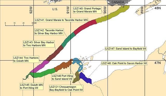
LSZ140-141-041615-
Grand Portage to Grand Marais MN-
Grand Marais to Taconite Harbor MN-
415 AM CDT Thu Jul 4 2024
.TODAY...Northwest wind 5 knots becoming south late in the
morning, then becoming southeast in the afternoon. Slight chance
of showers and thunderstorms late in the afternoon. Waves 1 foot
or less.
.TONIGHT...Northeast wind 5 to 10 knots. Slight chance of
thunderstorms in the evening. Slight chance of rain showers
through the night. Waves 1 to 2 feet.
.FRIDAY...Northeast wind 5 to 10 knots. Chance of rain showers
and slight chance of thunderstorms. Waves 1 to 2 feet.
.FRIDAY NIGHT...Northwest wind 5 to 10 knots. Slight chance of
rain showers in the evening. Waves 1 foot or less.
$$
LSZ142-143-041615-
Taconite Harbor to Silver Bay Harbor MN-
Silver Bay Harbor to Two Harbors MN-
415 AM CDT Thu Jul 4 2024
.TODAY...Northwest wind 5 knots becoming southeast late in the
morning, then becoming east 10 to 15 knots in the afternoon.
Slight chance of showers and thunderstorms late in the afternoon.
Waves 1 to 3 feet.
.TONIGHT...Northeast wind 10 to 15 knots. Gusts up to 20 knots
early in the morning. Chance of rain showers and slight chance of
thunderstorms. Waves 1 to 3 feet.
.FRIDAY...Northeast wind 10 to 15 knots. Gusts up to 20 knots
early in the morning. Slight chance of thunderstorms in the
morning. Chance of rain showers through the day. Chance of
thunderstorms in the afternoon. Waves 1 to 3 feet.
.FRIDAY NIGHT...Southwest wind 5 knots becoming west in the late
evening and overnight. Slight chance of showers and thunderstorms
in the evening. Waves 1 foot or less.
$$
LSZ144-145-041615-
Two Harbors to Duluth MN-Duluth MN to Port Wing WI-
415 AM CDT Thu Jul 4 2024
.TODAY...Northwest wind 5 knots becoming northeast 10 to 15 knots
in the late morning and afternoon. Slight chance of rain showers
early in the afternoon. Slight chance of thunderstorms in the
afternoon. Chance of rain showers late in the afternoon. Waves
1 to 3 feet.
.TONIGHT...Northeast wind 10 to 15 knots. Gusts up to 20 knots
early in the morning. Chance of rain showers in the evening.
Chance of thunderstorms through the night. Rain showers likely
after midnight. Waves 1 to 3 feet.
.FRIDAY...Northeast wind 10 to 15 knots. Gusts up to 20 knots
early in the morning. Chance of rain showers and slight chance of
thunderstorms. Waves 1 to 3 feet.
.FRIDAY NIGHT...Northeast wind 5 knots becoming west in the late
evening and overnight. Slight chance of showers and thunderstorms
in the evening. Waves 1 foot or less.
$$
LSZ146-041615-
Port Wing to Sand Island WI-
415 AM CDT Thu Jul 4 2024
.TODAY...Southwest wind 5 knots becoming northeast 10 to 15 knots
in the late morning and afternoon. Slight chance of showers and
thunderstorms late in the afternoon. Waves 1 to 3 feet.
.TONIGHT...Northeast wind 10 to 15 knots. Chance of rain showers
in the evening. Chance of thunderstorms through the night. Rain
showers likely after midnight. Waves 1 to 3 feet.
.FRIDAY...Northeast wind 10 to 15 knots easing to 5 to 10 knots
in the late morning and afternoon. Chance of rain showers and
slight chance of thunderstorms. Waves 1 to 3 feet.
.FRIDAY NIGHT...North wind 5 knots becoming west in the late
evening and overnight. Slight chance of rain showers in the
evening. Waves 1 foot or less.
$$
LSZ147-041615-
Sand Island to Bayfield WI-
415 AM CDT Thu Jul 4 2024
.TODAY...West wind 5 knots becoming northeast in the late morning
and early afternoon, then becoming east late in the afternoon.
Slight chance of showers and thunderstorms late in the afternoon.
Waves 1 to 2 feet.
.TONIGHT...Northeast wind 10 to 15 knots. Chance of rain showers
and slight chance of thunderstorms in the evening, then rain
showers likely and chance of thunderstorms after midnight. Waves
1 to 2 feet.
.FRIDAY...Northeast wind 10 to 15 knots easing to 5 to 10 knots
in the late morning and afternoon. Chance of rain showers and
slight chance of thunderstorms. Waves 1 to 3 feet.
.FRIDAY NIGHT...North wind 5 knots becoming west in the late
evening and overnight. Slight chance of rain showers in the
evening. Waves 1 foot or less.
$$
LSZ150-041615-
Outer Apostle Islands Beyond 5 NM from Mainland-
415 AM CDT Thu Jul 4 2024
.TODAY...West wind 5 knots becoming northwest late in the
morning, then becoming northeast in the afternoon. Slight chance
of rain showers late in the afternoon. Waves 1 to 2 feet.
.TONIGHT...Northeast wind 10 to 15 knots. Chance of rain showers
and slight chance of thunderstorms. Waves 1 to 3 feet.
.FRIDAY...Northeast wind 10 to 15 knots with gusts to around
20 knots easing to 5 to 10 knots with gusts to around 20 knots in
the afternoon. Chance of rain showers and slight chance of
thunderstorms. Waves 1 to 3 feet.
.FRIDAY NIGHT...North wind 5 to 10 knots becoming west in the
late evening and overnight. Slight chance of rain showers in the
evening. Waves 1 to 2 feet.
$$
LSZ121-041615-
Chequamegon Bay-Bayfield to Oak Point WI-
415 AM CDT Thu Jul 4 2024
.TODAY...Southwest wind 5 knots becoming east in the late morning
and afternoon. Slight chance of showers and thunderstorms late in
the afternoon. Waves 1 foot or less.
.TONIGHT...Northeast wind 5 to 10 knots. Chance of rain showers
in the evening. Chance of thunderstorms through the night. Rain
showers likely after midnight. Waves 1 foot or less.
.FRIDAY...Northeast wind 5 to 10 knots. Rain showers likely and
slight chance of thunderstorms in the morning, then chance of
rain showers in the afternoon. Waves 1 to 2 feet.
.FRIDAY NIGHT...North wind 5 knots becoming west in the late
evening and overnight. Slight chance of rain showers in the
evening. Waves 1 foot or less.
$$
LSZ148-041615-
Oak Point to Saxon Harbor WI-
415 AM CDT Thu Jul 4 2024
.TODAY...Southwest wind 5 knots becoming northeast in the late
morning and afternoon. Slight chance of showers and thunderstorms
late in the afternoon. Waves 1 to 2 feet.
.TONIGHT...Northeast wind 5 to 10 knots. Chance of rain showers
in the evening. Chance of thunderstorms through the night. Rain
showers likely after midnight. Waves 1 to 2 feet.
.FRIDAY...Northeast wind 10 to 15 knots easing to 5 to 10 knots
in the late morning and afternoon. Rain showers likely and slight
chance of thunderstorms in the morning, then chance of rain
showers in the afternoon. Waves 1 to 3 feet.
.FRIDAY NIGHT...North wind 5 to 10 knots becoming west after
midnight. Slight chance of rain showers in the evening. Waves
1 to 2 feet.
$$
Graphical marine forecasts are available online at:
weather.gov/greatlakes
Huyck
Open Waters Forecast
280
FZUS63 KMQT 040742
GLFLS
Open Lake Forecast for Lake Superior
National Weather Service Marquette MI
342 AM EDT Thu Jul 4 2024
For waters beyond 5 nautical miles of shore on Lake Superior.
Waves are the significant wave height - the average of the
highest 1/3 of the wave spectrum. Occasional wave height is the
average of the highest 1/10 of the wave spectrum.
.SYNOPSIS...As a weak 29.9 inch high pressure ridge over the Upper
Mississippi Valley settles over the western Great Lakes today, a
29.8 inch low pressure will gradually begin to organize over Iowa
and southern Minnesota. This low will deepen to 29.7 inches as it
tracks east, passing across Wisconsin late tonight and Friday
morning, Lower Michigan on Friday afternoon, then reaching southern
Quebec by Saturday afternoon. In its wake, another weak high
pressure ridge of 29.9 inches will shift east, reaching the western
Great Lakes during Saturday. As the ridge builds to 30.1 inches
while shifting to the Lower Great Lakes on Sunday, a 29.9 inch low
pressure trough will move east to Minnesota. This trough will
dissipate as it moves over Lake Superior on Monday.
LSZ162-041545-
Lake Superior west of a line from Saxon Harbor WI to Grand
Portage MN beyond 5NM-
342 AM EDT Thu Jul 4 2024 /242 AM CDT Thu Jul 4 2024/
.EARLY THIS MORNING...West winds 5 to 15 knots. Waves calm to
2 feet.
.TODAY...North winds 5 to 15 knots veering east late. A slight
chance of showers and thunderstorms by mid afternoon. Waves calm
to 2 feet.
.TONIGHT...Northeast winds 5 to 15 knots increasing to 10 to
20 knots after midnight. A chance of showers and a slight chance
of thunderstorms. Waves building to 1 to 3 feet, then subsiding
to calm to 2 feet.
.FRIDAY...Northeast winds 10 to 20 knots becoming north 5 to
15 knots late. A chance of showers and a slight chance of
thunderstorms. Waves subsiding to calm to 2 feet.
.FRIDAY NIGHT...West winds 5 to 15 knots. Waves calm to 2 feet.
.SATURDAY...West winds 5 to 15 knots backing southwest by mid
afternoon. Waves calm to 2 feet.
.SATURDAY NIGHT...Southwest winds 5 to 15 knots. Waves calm to
2 feet.
.SUNDAY...South winds 5 to 15 knots veering west. A chance of
showers. Waves calm to 2 feet.
.MONDAY...Southwest winds 5 to 15 knots veering northwest. Waves
calm to 2 feet.
$$
LSZ263-041545-
Lake Superior from Saxon Harbor WI to Upper Entrance to Portage
Canal MI 5NM off shore to the US/Canadian border including Isle
Royale National Park-
342 AM EDT Thu Jul 4 2024
.EARLY THIS MORNING...West winds 5 to 15 knots. Waves calm to
2 feet.
.TODAY...Northwest winds less than 10 knots becoming north 5 to
15 knots in the afternoon, then veering east late. Waves calm to
2 feet.
.TONIGHT...Northeast winds 5 to 15 knots. A chance of showers and
a slight chance of thunderstorms. Waves calm to 2 feet.
.FRIDAY...Northeast winds 5 to 15 knots increasing to 10 to
20 knots in the afternoon, then diminishing to 5 to 15 knots
late. A chance of showers and a slight chance of thunderstorms.
Waves building to 1 to 3 feet, then subsiding to calm to 2 feet.
.FRIDAY NIGHT...Northwest winds 5 to 15 knots backing west after
midnight. Waves calm to 2 feet.
.SATURDAY...West winds 5 to 15 knots backing southwest by mid
afternoon. Waves calm to 2 feet.
.SATURDAY NIGHT...Southwest winds 5 to 15 knots. Waves calm to
2 feet.
.SUNDAY...South winds 5 to 15 knots veering southwest. Waves calm
to 2 feet.
.MONDAY...Southwest winds 5 to 15 knots veering northwest. Waves
calm to 2 feet.
$$
LSZ264-041545-
Lake Superior from Upper Entrance to Portage Canal to Manitou
Island MI 5NM off shore to the US/Canadian Border-
342 AM EDT Thu Jul 4 2024
.EARLY THIS MORNING...West winds 5 to 15 knots. Waves calm to
2 feet.
.TODAY...Northwest winds 5 to 15 knots diminishing to less than
10 knots in the afternoon, then veering northeast late. Waves
calm to 2 feet.
.TONIGHT...East winds 5 to 15 knots backing northeast late. A
slight chance of showers after midnight. Waves calm to 2 feet.
.FRIDAY...Northeast winds 5 to 15 knots. A chance of showers.
Waves calm to 2 feet.
.FRIDAY NIGHT...Northwest winds 5 to 15 knots. A slight chance of
showers through midnight. Waves calm to 2 feet.
.SATURDAY...West winds 5 to 15 knots backing southwest by mid
afternoon. Waves calm to 2 feet.
.SATURDAY NIGHT...Southwest winds 5 to 15 knots. Waves calm to
2 feet.
.SUNDAY...South winds 5 to 15 knots. Waves calm to 2 feet.
.MONDAY...Southwest winds 5 to 15 knots veering northwest. Waves
calm to 2 feet.
$$
LSZ265-041545-
Lake Superior West of Line from Manitou Island to Marquette MI
Beyond 5NM from shore-
342 AM EDT Thu Jul 4 2024
.EARLY THIS MORNING...West winds 5 to 15 knots. Waves calm to
2 feet.
.TODAY...Northwest winds 5 to 15 knots veering northeast in the
afternoon, then veering east late. Waves calm to 2 feet.
.TONIGHT...East winds 5 to 15 knots. A chance of showers. A
slight chance of thunderstorms after midnight. Waves calm to
2 feet.
.FRIDAY...Northeast winds 5 to 15 knots increasing to 10 to
20 knots in the afternoon. Showers likely and a slight chance of
thunderstorms. Waves calm to 2 feet.
.FRIDAY NIGHT...North winds 10 to 20 knots backing northwest
after midnight. A chance of showers and a slight chance of
thunderstorms through midnight. Waves calm to 2 feet.
.SATURDAY...West winds 10 to 20 knots diminishing to 5 to
15 knots by mid afternoon. Waves calm to 2 feet.
.SATURDAY NIGHT...Southwest winds 5 to 15 knots. Waves calm to
2 feet.
.SUNDAY...Southeast winds 5 to 15 knots veering south. Waves calm
to 2 feet.
.MONDAY...Southwest winds 5 to 15 knots veering northwest. Waves
calm to 2 feet.
$$
LSZ266-041545-
Lake Superior East of a line from Manitou Island to Marquette MI
and West of a line from Grand Marais MI to the US/Canadian Border
Beyond 5NM from shore-
342 AM EDT Thu Jul 4 2024
.EARLY THIS MORNING...Northwest winds 5 to 15 knots. Patchy fog.
Waves 1 to 3 feet subsiding to calm to 2 feet.
.TODAY...Northwest winds 5 to 15 knots veering north late. Waves
calm to 2 feet.
.TONIGHT...Northeast winds 5 to 15 knots. A chance of showers and
a slight chance of thunderstorms after midnight. Waves calm to
2 feet.
.FRIDAY...Northeast winds 5 to 15 knots increasing to 10 to
20 knots in the afternoon. Showers likely and a chance of
thunderstorms. Waves calm to 2 feet.
.FRIDAY NIGHT...North winds 10 to 20 knots. A chance of showers
and a slight chance of thunderstorms. Waves building to 1 to
3 feet.
.SATURDAY...Northwest winds 10 to 20 knots becoming west 5 to
15 knots by mid afternoon. Waves subsiding to calm to 2 feet.
.SATURDAY NIGHT...Southwest winds 5 to 15 knots backing south
after midnight. Waves calm to 2 feet.
.SUNDAY...South winds 5 to 15 knots. Waves calm to 2 feet.
.MONDAY...Southwest winds 5 to 15 knots veering northwest. Waves
calm to 2 feet.
$$
LSZ267-041545-
Lake Superior from Grand Marais MI to Whitefish Point MI 5NM off
shore to the US/Canadian border-
342 AM EDT Thu Jul 4 2024
.EARLY THIS MORNING...Northwest winds 5 to 15 knots. Patchy fog.
Waves calm to 2 feet.
.TODAY...Northwest winds 5 to 15 knots. Patchy fog in the
morning. Waves calm to 2 feet.
.TONIGHT...North winds 5 to 15 knots backing northwest after
midnight, then veering north late. A chance of showers after
midnight. Waves calm to 2 feet.
.FRIDAY...East winds 10 to 20 knots backing north late. Showers
likely and a chance of thunderstorms. Waves calm to 2 feet.
.FRIDAY NIGHT...North winds 10 to 20 knots. A chance of showers
and thunderstorms. Waves building to 1 to 3 feet.
.SATURDAY...Northwest winds 10 to 20 knots backing west by mid
afternoon. Waves subsiding to calm to 2 feet.
.SATURDAY NIGHT...West winds 5 to 15 knots backing south after
midnight. Waves calm to 2 feet.
.SUNDAY...South winds 5 to 15 knots increasing to 10 to 20 knots.
A chance of showers. Waves calm to 2 feet.
.MONDAY...South winds 10 to 20 knots becoming southwest 5 to
15 knots. A chance of showers. Waves calm to 2 feet.
$$
LSZ261-041545-
MAFOR 0409/
Superior West 12700 11100 12200 11100 12110. A chance of showers
overnight. Waves 2 feet or less.
Superior North Central 11610 13700 11800 13200. Waves 2 feet or
less.
Superior South Central 11610 11700 11800 11100 14200. A chance of
showers overnight. Waves 2 feet or less.
Superior East 14700 11700 11800 12700. Waves 2 feet or less.
$$
Rolfson
Experimental modernized open lake forecast is available online at
weather.gov/mqt/glftable
Graphical marine forecasts are available online at:
weather.gov/greatlakes
Other Information
Great Lakes Water Levels and Forecasts - Provided by USACE
GLERL - NOAA Great Lakes Forecast System