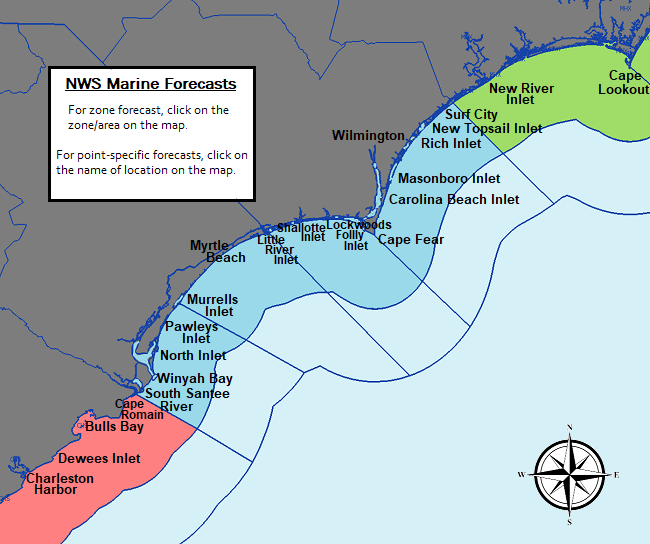
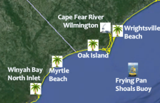
NWS Wilmington, NC is responsible for marine forecasts for the coastal waters from Surf City, NC to South Santee River, SC out to 20 nautical miles.
Forecasts are updated frequently based on the latest observations and forecast guidance.
To report unusual marine conditions, including waterspout, to the National Weather Service call toll free 800-697-3901.
The National Weather Service is soliciting feedback on a new proposed coastal waters forecast with wave detail.
All feedback is appreciated!
|
|
|
|
|
|
|
|
All information from our past marine web page can be found under the Other Marine Info menu tab at the top of this page, including the SECOORA Observation Map.
Marine Weather Message Issued: 07/02/2024 02:00:40 PM UTC
453
WHUS72 KILM 021000
MWWILM
URGENT - MARINE WEATHER MESSAGE
National Weather Service Wilmington NC
600 AM EDT Tue Jul 2 2024
AMZ250-252-021100-
/O.EXP.KILM.SC.Y.0034.000000T0000Z-240702T1000Z/
Coastal waters from Surf City to Cape Fear NC out 20 nm-
Coastal waters from Cape Fear NC to Little River Inlet SC out
20 nm-
600 AM EDT Tue Jul 2 2024
...SMALL CRAFT ADVISORY HAS EXPIRED...
$$
IGB
You can compare the forecast below with the proposed version, which includes enhanced
wave detail over the ocean zones by clicking here.
196
FZUS52 KILM 040808
CWFILM
Coastal Waters Forecast
National Weather Service Wilmington NC
408 AM EDT Thu Jul 4 2024
Surf City NC to South Santee River SC out 20 NM
AMZ200-042115-
408 AM EDT Thu Jul 4 2024
.Synopsis for coastal waters from Surf City North Carolina to
South Santee River South Carolina out to 20 nautical miles...
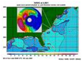
Long period swells from Hurricane Beryl will begin to arrive
today, and become the dominant wave set by tonight. High pressure
will settle offshore, bringing onshore flow. Better rain chances
are expected by the weekend.
$$
AMZ250-042115-
Coastal waters from Surf City to Cape Fear NC out 20 nm-
408 AM EDT Thu Jul 4 2024
.THROUGH 7 AM...SE winds 5 kt. Seas 3 ft. Wave Detail: SE 2 ft at
7 seconds and SE 1 ft at 14 seconds.
.TODAY...SE winds 5 to 10 kt. Seas 2 to 3 ft. Wave Detail: E 2 ft
at 6 seconds and SE 2 ft at 9 seconds.
.TONIGHT...S winds 10 kt. Seas 3 ft. Wave Detail: SE 3 ft at
12 seconds and S 1 ft at 4 seconds.
.FRI...S winds 10 to 15 kt. Gusts up to 20 kt in the afternoon.
Seas 2 to 3 ft. Wave Detail: SE 3 ft at 11 seconds and S 2 ft at
3 seconds. A slight chance of showers and tstms in the afternoon.
.FRI NIGHT...S winds 10 to 15 kt with gusts up to 20 kt. Seas
3 to 4 ft. Wave Detail: S 3 ft at 4 seconds and SW 2 ft at
4 seconds.
.SAT...S winds 10 to 15 kt. Gusts up to 20 kt in the afternoon.
Seas 3 ft. Wave Detail: S 2 ft at 4 seconds and E 2 ft at
9 seconds.
.SAT NIGHT...S winds 10 to 15 kt. Gusts up to 20 kt in the
evening. Seas 3 ft. Wave Detail: S 2 ft at 4 seconds and SE 2 ft
at 8 seconds.
.SUN...S winds 5 to 10 kt. Seas 2 to 3 ft. A chance of showers. A
chance of tstms in the afternoon.
.SUN NIGHT...S winds 5 to 10 kt. Seas 2 to 3 ft. A chance of
showers and tstms in the evening.
.MON...SE winds 5 to 10 kt. Seas 2 to 3 ft. A chance of showers.
A chance of tstms in the afternoon.
.MON NIGHT...S winds 5 to 10 kt. Seas 2 to 3 ft. A chance of
tstms in the evening. A chance of showers.
Winds and seas higher in and near tstms.
$$
AMZ252-042115-
Coastal waters from Cape Fear NC to Little River Inlet SC out
20 nm-
408 AM EDT Thu Jul 4 2024
.THROUGH 7 AM...SE winds 5 kt. Seas 2 to 3 ft. Wave Detail: SE
2 ft at 7 seconds and SE 1 ft at 14 seconds.
.TODAY...SE winds 5 to 10 kt. Seas 2 to 3 ft. Wave Detail: E 2 ft
at 6 seconds and SE 2 ft at 9 seconds.
.TONIGHT...S winds 10 kt. Seas 2 to 3 ft. Wave Detail: SE 3 ft at
12 seconds and S 2 ft at 3 seconds.
.FRI...SW winds 10 to 15 kt. Seas 2 to 3 ft. Wave Detail: SE 3 ft
at 11 seconds and S 2 ft at 3 seconds.
.FRI NIGHT...S winds 10 to 15 kt. Gusts up to 20 kt in the
evening. Seas 3 ft. Wave Detail: SE 3 ft at 10 seconds and S 2 ft
at 4 seconds.
.SAT...S winds 10 to 15 kt. Seas 2 to 3 ft. Wave Detail: S 2 ft
at 4 seconds and SE 2 ft at 9 seconds.
.SAT NIGHT...S winds 10 to 15 kt. Seas 2 to 3 ft. Wave Detail: S
2 ft at 4 seconds and SE 2 ft at 8 seconds.
.SUN...S winds 5 to 10 kt. Seas 2 to 3 ft. A chance of showers.
.SUN NIGHT...S winds 5 to 10 kt. Seas 2 to 3 ft.
.MON...SE winds 5 to 10 kt. Seas 2 to 3 ft. A chance of showers.
.MON NIGHT...S winds 5 to 10 kt. Seas 2 to 3 ft. A chance of
showers after midnight.
$$
AMZ254-042115-
Coastal waters from Little River Inlet to Murrells Inlet SC out
20 nm-
408 AM EDT Thu Jul 4 2024
.THROUGH 7 AM...SE winds 5 kt. Seas 2 to 3 ft. Wave Detail: E
2 ft at 6 seconds and SE 2 ft at 9 seconds.
.TODAY...SE winds 5 to 10 kt. Seas 2 to 3 ft. Wave Detail: E 2 ft
at 6 seconds and SE 2 ft at 9 seconds.
.TONIGHT...S winds 10 to 15 kt. Seas 2 to 3 ft. Wave Detail: SE
3 ft at 12 seconds and S 2 ft at 4 seconds.
.FRI...SW winds 10 to 15 kt. Gusts up to 20 kt in the afternoon.
Seas 2 to 3 ft. Wave Detail: S 3 ft at 4 seconds and SE 3 ft at
11 seconds.
.FRI NIGHT...S winds 10 to 15 kt with gusts up to 20 kt. Seas
3 ft. Wave Detail: S 3 ft at 4 seconds and SE 2 ft at 10 seconds.
.SAT...S winds 10 to 15 kt. Gusts up to 20 kt in the afternoon.
Seas 2 to 3 ft. Wave Detail: S 2 ft at 4 seconds and SE 2 ft at
9 seconds.
.SAT NIGHT...S winds 10 to 15 kt. Gusts up to 20 kt in the
evening. Seas 2 to 3 ft. Wave Detail: S 2 ft at 5 seconds and SE
2 ft at 8 seconds. A chance of showers.
.SUN...S winds 5 to 10 kt. Seas 2 to 3 ft. A chance of showers. A
chance of tstms in the afternoon.
.SUN NIGHT...S winds 5 to 10 kt. Seas 2 to 3 ft. A chance of
tstms in the evening. A chance of showers.
.MON...SE winds 5 to 10 kt. Seas 2 ft. A chance of showers. A
chance of tstms in the afternoon.
.MON NIGHT...S winds 5 to 10 kt. Seas 2 to 3 ft. A chance of
tstms in the evening. A chance of showers.
Winds and seas higher in and near tstms.
$$
AMZ256-042115-
Coastal waters from Murrells Inlet to South Santee River SC out
20 nm-
408 AM EDT Thu Jul 4 2024
.THROUGH 7 AM...SE winds 5 kt. Seas 2 to 3 ft. Wave Detail: E
2 ft at 6 seconds and SE 2 ft at 9 seconds.
.TODAY...SE winds 5 to 10 kt. Seas 2 to 3 ft. Wave Detail: E 2 ft
at 6 seconds and SE 2 ft at 9 seconds.
.TONIGHT...S winds 10 to 15 kt. Seas 2 to 3 ft. Wave Detail: SE
3 ft at 12 seconds and S 2 ft at 4 seconds.
.FRI...SW winds 5 to 10 kt, becoming S 10 to 15 kt with gusts up
to 20 kt in the afternoon. Seas 2 to 3 ft. Wave Detail: S 3 ft at
4 seconds and SE 3 ft at 11 seconds.
.FRI NIGHT...S winds 10 to 15 kt with gusts up to 20 kt. Seas
3 ft. Wave Detail: S 3 ft at 4 seconds and SE 2 ft at 10 seconds.
.SAT...S winds 10 to 15 kt. Gusts up to 20 kt in the afternoon.
Seas 2 to 3 ft. Wave Detail: SE 3 ft at 9 seconds and S 2 ft at
4 seconds.
.SAT NIGHT...S winds 10 to 15 kt. Gusts up to 20 kt in the
evening. Seas 2 to 3 ft. Wave Detail: SE 3 ft at 8 seconds and S
2 ft at 4 seconds. A chance of showers.
.SUN...SE winds 5 to 10 kt. Seas 2 to 3 ft. A chance of showers.
A chance of tstms in the afternoon.
.SUN NIGHT...SE winds 5 to 10 kt. Seas 2 to 3 ft. A chance of
showers and tstms.
.MON...SE winds 5 to 10 kt. Seas 2 ft. A chance of showers. A
chance of tstms in the afternoon.
.MON NIGHT...S winds 5 to 10 kt. Seas 2 to 3 ft. A chance of
showers and tstms.
Winds and seas higher in and near tstms.
$$
IGB
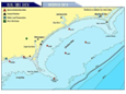
For a more detailed look at the marine zones associated with our area go here.
356
FZNT22 KWBC 040825
OFFNT2
Offshore Waters Forecast
NWS Ocean Prediction Center Washington DC
425 AM EDT Thu Jul 4 2024
West central North Atlantic continental shelf and slope waters
beyond 20 nm to 250 nm offshore, including south of Georges Bank
from 1000 fm to 250 nm offshore.
Seas given as significant wave height, which is the average
height of the highest 1/3 of the waves. Individual waves may be
more than twice the significant wave height.
Locally higher winds and seas can be expected in and near tstms.
The National Weather Service is accepting public comments until
July 29 2024 on a proposal to replace feet with meters when
describing seas in a variety of National Marine Center text
and graphical products for the Offshore and High Seas Areas
only. To learn more please visit the following URL:
https://ocean.weather.gov/proposed-meters.php
ANZ899-041945-
425 AM EDT Thu Jul 4 2024
.SYNOPSIS FOR MID ATLC WATERS...A stationary front across the far
southern waters will linger today before drifting S of the
waters late tonight. Meanwhile high pressure ridging will remain
in place over the northern and central waters. The ridge will
settle across the waters E of Cape Hatteras Fri night through Sun
night, while a cold front slowly approaches the northern waters
from the W by late Sun. The front will become stationary W of the
northern waters on Mon before diminishing Mon night. Chesapeake
NAVTEX is reported inoperable. Technicians are aware. We
apologize for the inconvenience.
$$
ANZ820-041945-
Hudson Canyon to Baltimore Canyon to 1000 FM-
425 AM EDT Thu Jul 4 2024
.TODAY...S to SW winds 5 to 15 kt, becoming S 10 to 20 kt. Seas
3 to 5 ft.
.TONIGHT...S winds 10 to 15 kt, becoming SW 10 to 20 kt. Seas
4 to 5 ft. Isolated tstms. Scattered showers.
.FRI...SW winds 10 to 15 kt, becoming S 10 to 20 kt. Seas 3 to
5 ft. Scattered showers.
.FRI NIGHT...S winds 15 to 25 kt. Seas 4 to 7 ft. Isolated
tstms.
.SAT...S winds 15 to 25 kt. Seas 5 to 7 ft.
.SAT NIGHT...S winds 20 to 25 kt, becoming SW 15 to 25 kt. Seas
4 to 7 ft.
.SUN...SW winds 10 to 20 kt, diminishing to 5 to 15 kt. Seas
3 to 6 ft.
.SUN NIGHT...SW winds 5 to 15 kt, diminishing to less than
10 kt. Seas 3 to 5 ft.
.MON...S to SW winds less than 10 kt. Seas 3 to 4 ft.
.MON NIGHT...S winds 5 to 10 kt. Seas 3 to 4 ft.
$$
ANZ915-041945-
Between 1000FM and 38.5 N west of 69 W-
425 AM EDT Thu Jul 4 2024
.TODAY...Variable winds less than 10 kt, becoming S to SW. Seas
3 to 5 ft.
.TONIGHT...S to SW winds 5 to 15 kt. Seas 4 to 5 ft.
.FRI...S to SW winds 5 to 15 kt, becoming S 10 to 20 kt. Seas
4 to 5 ft. Scattered showers.
.FRI NIGHT...S winds 15 to 25 kt. Seas 4 to 7 ft. Isolated
showers.
.SAT...S winds 15 to 25 kt. Seas 4 to 7 ft.
.SAT NIGHT...S to SW winds 15 to 25 kt. Seas 5 to 7 ft.
.SUN...SW winds 10 to 20 kt. Seas 4 to 6 ft.
.SUN NIGHT...SW winds 5 to 15 kt. Seas 4 to 5 ft.
.MON...SW winds 5 to 10 kt. Seas 3 to 5 ft.
.MON NIGHT...S to SW winds 5 to 10 kt. Seas 3 to 5 ft.
$$
ANZ920-041945-
Baltimore Canyon to 69W east of 1000 FM and south of 38.5N to
250 NM offshore-
425 AM EDT Thu Jul 4 2024
.TODAY...Variable winds 5 to 15 kt. Seas 3 to 6 ft.
.TONIGHT...S to SW winds 5 to 15 kt. Seas 4 to 5 ft.
.FRI...S to SW winds 5 to 15 kt, becoming S 10 to 20 kt. Seas
4 to 5 ft. Scattered showers. Isolated tstms.
.FRI NIGHT...S winds 10 to 20 kt. Seas 3 to 6 ft. Isolated
showers.
.SAT...S to SW winds 15 to 25 kt. Seas 3 to 6 ft.
.SAT NIGHT...S winds 15 to 25 kt, becoming SW. Seas 4 to 7 ft.
.SUN...SW winds 10 to 20 kt. Seas 4 to 6 ft.
.SUN NIGHT...S to SW winds 5 to 15 kt. Seas 3 to 5 ft.
.MON...S to SW winds 5 to 10 kt. Seas 3 to 5 ft.
.MON NIGHT...S winds 5 to 10 kt. Seas 3 to 5 ft.
$$
ANZ905-041945-
East of 69W to the Hague Line between 1000 FM and 39N-
425 AM EDT Thu Jul 4 2024
.TODAY...N to NE winds 10 to 20 kt, becoming N 5 to 15 kt. Seas
4 to 7 ft.
.TONIGHT...Variable winds less than 10 kt. Seas 4 to 5 ft.
.FRI...S winds 5 to 15 kt. Seas 3 to 5 ft.
.FRI NIGHT...S winds 5 to 15 kt. Seas 3 to 4 ft.
.SAT...S winds 5 to 15 kt. Seas 3 to 5 ft.
.SAT NIGHT...S to SW winds 10 to 20 kt. Seas 4 to 5 ft.
.SUN...SW winds 10 to 15 kt. Seas 4 to 5 ft.
.SUN NIGHT...SW winds 10 to 15 kt. Seas 4 to 5 ft.
.MON...SW winds 5 to 15 kt. Seas 4 to 5 ft.
.MON NIGHT...SW winds 5 to 10 kt. Seas 3 to 5 ft.
$$
ANZ910-041945-
East of 69W and south of 39N to 250 NM offshore-
425 AM EDT Thu Jul 4 2024
.TODAY...N winds 10 to 20 kt, diminishing to 5 to 15 kt. Seas
5 to 8 ft.
.TONIGHT...NE winds less than 10 kt, becoming variable. Seas
4 to 6 ft.
.FRI...Variable winds less than 10 kt. Seas 3 to 5 ft.
.FRI NIGHT...S to SE winds less than 10 kt. Seas 3 to 4 ft.
.SAT...S to SW winds 5 to 15 kt. Seas 3 to 5 ft.
.SAT NIGHT...S to SW winds 10 to 15 kt. Seas 3 to 5 ft.
.SUN...SW winds 10 to 15 kt. Seas 4 to 5 ft.
.SUN NIGHT...S to SW winds 5 to 15 kt. Seas 4 to 5 ft.
.MON...S to SW winds 5 to 10 kt. Seas 4 to 5 ft.
.MON NIGHT...S to SW winds 5 to 10 kt. Seas 4 to 5 ft.
$$
ANZ825-041945-
Baltimore Canyon to Cape Charles Light to 100 NM offshore-
425 AM EDT Thu Jul 4 2024
.TODAY...S to SW winds 5 to 10 kt, becoming S 10 to 20 kt. Seas
3 to 4 ft.
.TONIGHT...S winds 15 to 20 kt, becoming SW. Seas 4 to 5 ft.
Isolated tstms. Scattered showers.
.FRI...SW winds 10 to 15 kt, becoming S 15 to 25 kt. Seas 4 to
5 ft.
.FRI NIGHT...S winds 15 to 25 kt. Seas 5 to 6 ft. Isolated
tstms.
.SAT...S winds 15 to 25 kt. Seas 4 to 6 ft.
.SAT NIGHT...S winds 15 to 25 kt, becoming SW 10 to 20 kt. Seas
4 to 6 ft.
.SUN...S to SW winds 5 to 15 kt. Seas 3 to 5 ft.
.SUN NIGHT...S winds 5 to 10 kt, becoming SW. Seas 3 to 4 ft.
.MON...S to SW winds 5 to 10 kt. Seas 3 to 4 ft.
.MON NIGHT...S winds 10 to 15 kt. Seas 3 to 4 ft.
$$
ANZ828-041945-
Cape Charles Light to Currituck Beach Light to 100 NM offshore-
425 AM EDT Thu Jul 4 2024
.TODAY...W to SW winds less than 10 kt, becoming S 10 to 20 kt.
Seas 3 to 5 ft.
.TONIGHT...S winds 10 to 20 kt, becoming SW. Seas 4 to 5 ft.
Isolated showers and tstms.
.FRI...SW winds 10 to 15 kt, becoming S 15 to 25 kt. Seas 3 to
5 ft.
.FRI NIGHT...S winds 15 to 25 kt. Seas 4 to 6 ft. Isolated
tstms.
.SAT...S winds 15 to 25 kt. Seas 4 to 6 ft.
.SAT NIGHT...S to SW winds 10 to 20 kt. Seas 3 to 5 ft.
.SUN...SW winds 5 to 10 kt, becoming S 5 to 15 kt. Seas 3 to
4 ft.
.SUN NIGHT...S winds 10 to 15 kt, becoming S to SW 5 to 10 kt.
Seas 3 to 4 ft.
.MON...S to SW winds 5 to 10 kt. Seas 3 to 4 ft.
.MON NIGHT...S winds 10 to 15 kt, diminishing to 5 to 10 kt.
Seas 3 to 4 ft.
$$
ANZ925-041945-
Baltimore Canyon to Hatteras Canyon between 100 NM and 250 NM
offshore-
425 AM EDT Thu Jul 4 2024
.TODAY...N winds less than 10 kt, becoming N to NE, then,
becoming variable. Seas 3 to 6 ft.
.TONIGHT...S winds 5 to 15 kt, becoming SW. Seas 4 to 6 ft.
.FRI...S to SW winds 10 to 20 kt. Seas 4 to 5 ft.
.FRI NIGHT...S winds 10 to 20 kt. Seas 3 to 6 ft.
.SAT...S winds 10 to 20 kt. Seas 3 to 6 ft.
.SAT NIGHT...S to SW winds 15 to 25 kt. Seas 3 to 6 ft.
.SUN...S to SW winds 5 to 15 kt. Seas 3 to 5 ft.
.SUN NIGHT...S winds 5 to 15 kt, becoming 5 to 10 kt. Seas 3 to
4 ft.
.MON...S winds 5 to 10 kt. Seas 3 to 4 ft.
.MON NIGHT...S winds 5 to 10 kt. Seas 3 to 5 ft.
$$
ANZ830-041945-
Currituck Beach Light to Cape Hatteras to 100 NM offshore-
425 AM EDT Thu Jul 4 2024
.TODAY...Variable winds less than 10 kt, becoming S. Seas 3 to
5 ft.
.TONIGHT...S winds 10 to 20 kt, becoming SW 5 to 15 kt. Seas
4 to 5 ft.
.FRI...S to SW winds 5 to 15 kt, becoming S 10 to 20 kt. Seas
4 to 5 ft.
.FRI NIGHT...S winds 10 to 20 kt. Seas 4 to 5 ft.
.SAT...S winds 10 to 20 kt. Seas 4 to 5 ft.
.SAT NIGHT...S winds 10 to 20 kt. Seas 4 to 5 ft.
.SUN...S to SW winds 5 to 10 kt, becoming S 10 to 15 kt. Seas
3 to 4 ft.
.SUN NIGHT...S winds 10 to 15 kt, diminishing to 5 to 10 kt.
Seas 3 to 4 ft.
.MON...S winds 5 to 10 kt. Seas 3 to 4 ft.
.MON NIGHT...S winds 5 to 10 kt. Seas 3 to 4 ft.
$$
ANZ833-041945-
Cape Hatteras to Cape Fear to 100 NM Offshore.-
425 AM EDT Thu Jul 4 2024
.TODAY...Variable winds less than 10 kt, becoming S to SE. Seas
3 to 5 ft.
.TONIGHT...S winds 5 to 15 kt. Seas 3 to 5 ft.
.FRI...S winds 5 to 15 kt. Seas 3 to 5 ft.
.FRI NIGHT...S winds 10 to 20 kt. Seas 4 to 5 ft.
.SAT...S winds 10 to 15 kt, becoming 10 to 20 kt. Seas 3 to
5 ft.
.SAT NIGHT...S winds 15 to 20 kt, diminishing to 5 to 15 kt.
Seas 3 to 5 ft.
.SUN...S winds 5 to 10 kt. Seas 3 to 4 ft.
.SUN NIGHT...S winds 10 to 15 kt, diminishing to 5 to 10 kt.
Seas 3 to 4 ft.
.MON...S to SE winds 5 to 10 kt. Seas 3 to 4 ft.
.MON NIGHT...S winds 5 to 10 kt. Seas 3 to 4 ft.
$$
ANZ930-041945-
Hatteras Canyon to Cape Fear between 100 NM and 250 NM offshore-
425 AM EDT Thu Jul 4 2024
.TODAY...N winds less than 10 kt, becoming NE, then, diminishing
to less than 10 kt. Seas 4 to 6 ft.
.TONIGHT...E winds less than 10 kt, becoming variable. Seas 4 to
5 ft.
.FRI...Variable winds less than 10 kt, becoming S to SE. Seas
4 to 5 ft.
.FRI NIGHT...S to SE winds 5 to 15 kt. Seas 3 to 5 ft.
.SAT...S winds 5 to 15 kt. Seas 3 to 5 ft.
.SAT NIGHT...S to SE winds 5 to 15 kt. Seas 3 to 5 ft.
.SUN...S to SE winds 5 to 10 kt. Seas 3 to 4 ft.
.SUN NIGHT...S winds 5 to 10 kt. Seas 3 to 4 ft.
.MON...S to SE winds 5 to 10 kt. Seas 3 to 4 ft.
.MON NIGHT...S to SE winds 5 to 10 kt. Seas 4 to 5 ft.
$$
ANZ835-041945-
Cape Fear to 31N to 1000 FM-
425 AM EDT Thu Jul 4 2024
.TODAY...E to NE winds 5 to 15 kt. Seas 3 to 5 ft. Isolated
showers and tstms.
.TONIGHT...S to SE winds 5 to 15 kt. Seas 3 to 5 ft.
.FRI...Variable winds less than 10 kt, becoming S to SE. Seas
3 to 5 ft.
.FRI NIGHT...S winds 5 to 15 kt. Seas 3 to 4 ft.
.SAT...S to SW winds 5 to 15 kt, becoming S to SE. Seas 3 to
4 ft.
.SAT NIGHT...S to SE winds 5 to 15 kt, becoming S 5 to 10 kt.
Seas 3 to 4 ft.
.SUN...S to SE winds less than 10 kt. Seas 3 to 4 ft.
.SUN NIGHT...SE winds 5 to 10 kt, becoming S. Seas 3 to 4 ft.
.MON...Variable winds less than 10 kt, becoming SE. Seas 3 to
4 ft.
.MON NIGHT...S to SW winds less than 10 kt. Seas 3 to 4 ft.
$$
ANZ935-041945-
Cape Fear to 31N east of 1000 FM to 250 NM offshore-
425 AM EDT Thu Jul 4 2024
.TODAY...E to NE winds 5 to 15 kt, becoming NE 10 to 20 kt,
then, becoming E 5 to 15 kt. Seas 4 to 5 ft. Isolated showers
and tstms.
.TONIGHT...E winds 5 to 15 kt, becoming 5 to 10 kt. Seas 4 to
5 ft.
.FRI...E to SE winds 5 to 10 kt. Seas 4 to 5 ft.
.FRI NIGHT...S to SE winds 5 to 15 kt, becoming 5 to 10 kt. Seas
4 to 5 ft.
.SAT...SE winds 5 to 10 kt, becoming 5 to 15 kt. Seas 4 to 5 ft.
.SAT NIGHT...SE winds 10 to 15 kt, diminishing to 5 to 10 kt.
Seas 4 to 5 ft.
.SUN...SE winds 5 to 10 kt. Seas 3 to 4 ft.
.SUN NIGHT...S to SE winds 5 to 10 kt. Seas 3 to 4 ft.
.MON...SE winds less than 10 kt. Seas 3 to 4 ft.
.MON NIGHT...S to SE winds less than 10 kt. Seas 3 to 4 ft.
$$
.Forecaster Connelly. Ocean Prediction Center.
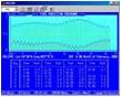
NWS Tide Predictions
| Wrightsville Beach - Johny Mercer Pier | Cape Fear River-Downtown Wilmington | Myrtle Beach - Springmaid Pier |
 |
 |
 |
NOAA Tides and Currents Webpage

Forecast Products and Models |
|||||
|
Forecasts 
|
|
|
|
|
|
|
|

|
|
|

|
|
Data and Observations |
|||||
|
|
|
|

|

|
|
|

|
 |
|
||
Other References |
|||||
|
|
|
|

|

|
|
|
|
|
||||


 Coastal Flood