 |
 |
 |
 |
|
 |
 |
 |
 |
 |
||
| Winter Weather | Wind Chill | Frost/ Freeze | Heat | Wind | Tropical | Flood |
|
|
Click a hazard above to jump to specific criteria
| Hazardous Weather Outlook | Highlights the risk for hazardous weather within the next 7 days. There is a text version and a graphical version. |
 |
 |
 |
 |
 |
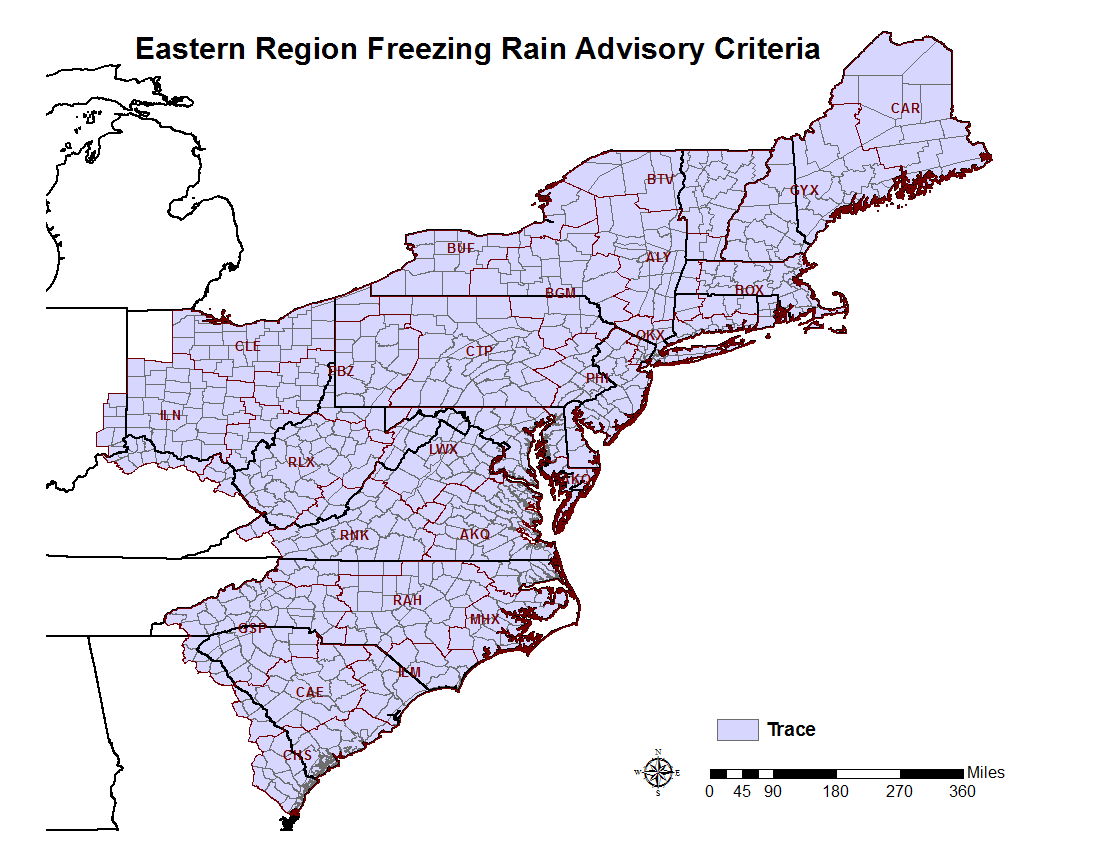
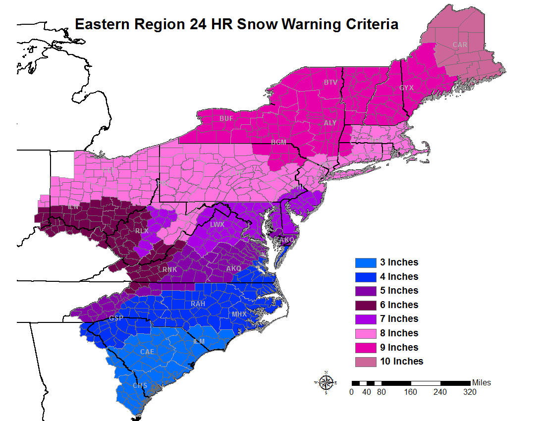
| Ice Storm Warning | Freezing Rain Advisory | 12-hour Snow Warning | 24-hour Snow Warning | 12-hour Snow Advisory |
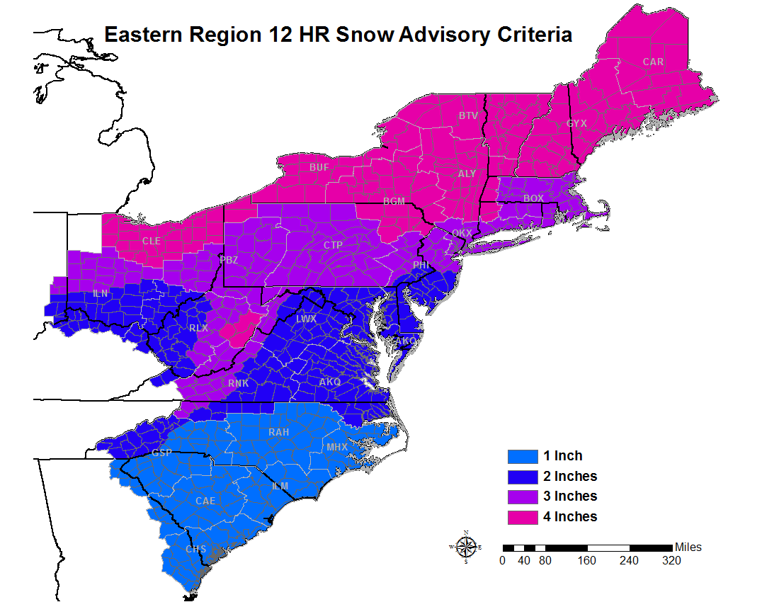
| Winter Weather Advisory |
Any of the following: 3” average snowfall in a county in 24 hours (2-4 inches in the forecast). 1” average snowfall in a county in 12 hours (1-2 inches in the forecast). Sleet accumulation expected to cover the ground (less than ½”). Glazing of freezing rain on elevated surfaces |
| Winter Storm Watch |
Conditions are favorable for a winter storm event of Snow, Sleet, or Freezing Rain, or a combination of events to meet or exceed Winter Storm Warning, Ice Storm Warning or Blizzard Warning Criteria in the next 18 to 36 hours. |
| Winter Storm Warning |
Any of the following is forecast in the next 12 to 24 hours: 3” average snowfall in a county in 12 hours (2-4 inches in forecast). 4” average snowfall in a county in 24 hours (3-5 inches in forecast). ½” or more of sleet. ¼” accretion of freezing rain on elevated surfaces. Significant impact events (heavy, wet snow or a mixture of snow, freezing rain and sleet) that affect transportation, commerce, or electrical power service. |
| Blizzard Warning |
Visibility < ¼ mile in snow and/or blowing snow AND sustained or frequent gusts > 35 MPH for 3 or more hours. |
| Ice Storm Warning |
Issued when FREEZING precipitation is the main type of wintry precipitation and it is expected to accumulate to ¼ inch or greater.
|
| Special Weather Statement for Black Ice |
When we receive reports of black ice or when conditions become conducive for such conditions such as wet roadways due to rain or melting snow followed by a rapid temperature drop below freezing. Usually issued if the event occurs during a high impact travel time. |
 |
 |
 |
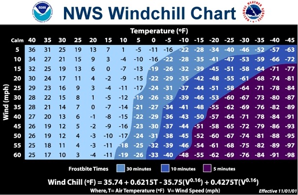
| Wind Chill Advisory | Wind Chill Warning |
| Wind Chill Watch | Conditions are favorable for wind chill temperatures to meet or exceed local Wind Chill Warning criteria in the next 18 to 36 hours. |
| Wind Chill of 0°F to -14°F is expected | |
| Wind Chill Warning | Wind Chill of below -15°F is expected |
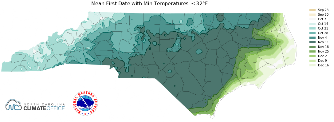
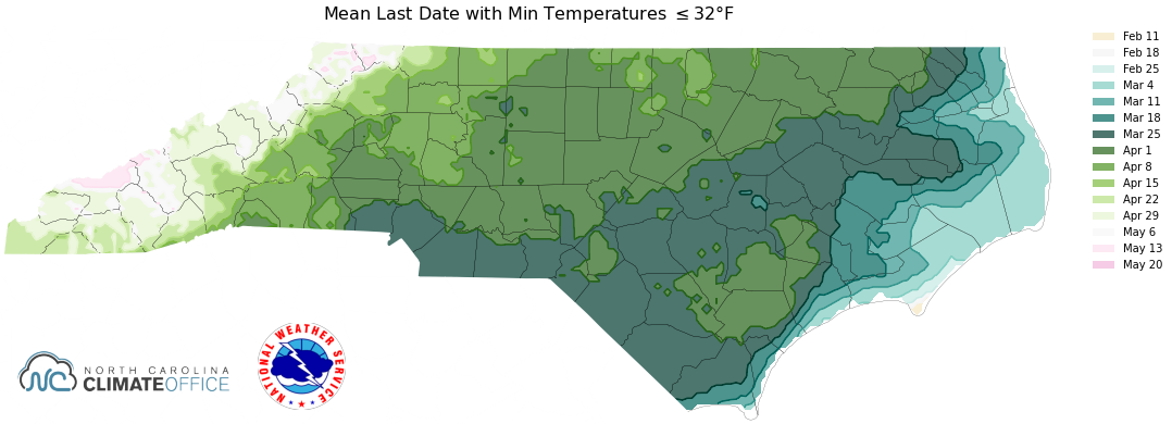
| Freeze Watch | Conditions are favorable in the next 24 to 48 hours for a freeze event to meet or exceed Freeze Warning criteria, during the growing season, which is typically between March 15 and November 15. |
| Freeze Warning | Issued when minimum temperatures are forecast to be 32 degrees or less during the locally-defined growing season (with or without frost). The growing season will officially end in autumn when minimum temperatures drop to 32 degrees or less, across half or more of each individual forecast zone, for three or more hours. |
| Frost Advisory |
Issued when minimum temperatures are forecast to be 33 to 36 degrees and conditions are favorable for the development of at least areas of frost during the locally-defined growing season, which is typically between March 15 and November 15. Note: 32°F to 28°F is a Freeze where as temperatures less than 28°F is considered a Hard Freeze |
| Freezing Fog Advisory | Issued when ground and/or elevated surfaces are below freezing and fog is expected to cause some light ice accumulation. |
 |
 |
| Excessive Heat Watch |
Conditions are favorable for an excessive heat event to meet or exceed local Excessive Heat Warning criteria; valid for the entire heat episode and not just the daytime hours. Note: Excessive heat occurs from a combination of hot temperatures and high humidity. |
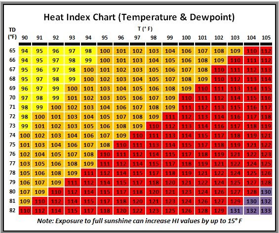
| Excessive Heat Warning | Heat index values 110 F or higher for 2 hours or more. |
| Heat Advisory | Heat index values 105 F to 109 F for 2 hours or more and/or excessive heat for 3 consecutive days. |
| High Wind Watch |
Issued whenever sustained winds ≥ 40 MPH (35 KT) and/or gusts ≥ 50-58 MPH) are likely to occur in the next 12 to 48 hours. |
| High Wind Warning |
Sustained wind ≥ 40 MPH (35 KT) for 1 hour or more and/or Frequent gusts ≥ 50 MPH OR Any gust ≥ 58 MPH (50 KT). |
| Wind Advisory |
Sustained winds of 31-39 MPH for 1 hour or more and/or frequent gusts 40 - 45 MPH, or gusts 46 to 57 MPH for any duration. |
| Dense Fog Advisory | Widespread fog reducing the visibility to ¼ mile or less. |
| Dense Smoke Advisory | Widespread smoke reducing the visibility to ¼ mile or less. |
| Dust Storm Warning | Widespread blowing dust reducing the visibility to ¼ mile or less with winds of at least 25 mph. |
| Blowing Dust Advisory | Widespread blowing dust reducing the visibility to between ¼ mile and 1 mile. Winds of at least 25 mph are usually required. |
| Air Quality Alert | Air Quality Index (AQI) exceeding 100 (code orange air quality alert) as per the North Carolina Department of Environmental Quality (DEQ). |
| Hurricane Watch | Sustained winds of 64 knots (74 mph) or greater are possible within 48 hours. Issued by the National Hurricane Center. |
| Hurricane Warning | Sustained winds of 64 knots (74 mph) or greater are expected in the area within 36 hours. |
| Tropical Storm Watch | Sustained winds of 34 – 63 knots (39 – 73 mph) are possible within 48 hours. |
| Tropical Storm Warning | Sustained winds of 34 – 63 knots (39 – 73 mph) are expected within 36 hours. |
| Extreme Wind Warning (EWW) |
An Extreme Wind Warning is a short duration product designed to provide advance notice of the onset of extreme winds of a major hurricane (category 3 or higher) usually associated with the eyewall of a hurricane. An EWW for extreme tropical cyclone winds should be issued when surface winds of 100 KT (115 MPH) or greater are occurring or are expected to occur within one hour for the warned area. |
| Flood Watch | Conditions are favorable for flooding in the next 36 hours. |
| Flash Flood Warning |
Flash flooding is occurring or imminent. Flash flooding is defined by a threat to life or property which would result in the need for immediate action to avoid or mitigate the threat. |
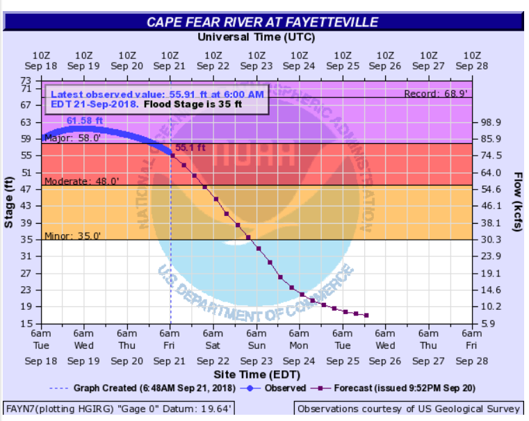
| River Flood Warning | River flooding for specific river points is occurring or imminent. Flood Warnings for rivers are issued for any high flow, overflow, or inundation threatening lives and property which can be quantified or indexed at specific locations and are not covered by flash flood products. |
| Flood Advisory | Issued when elevated stream flow or significant ponding of water occurs or is expected to occur. Flood Advisories may be issued for urban flooding or small stream flooding or a combination of both. This is the most common flood related product RAH issues. |
| Tornado Watch | Conditions are favorable for tornadoes. (Issued by SPC) |
| Tornado Warning | A tornado has been sighted or is indicated by radar. |
| Severe Thunderstorm Watch | Conditions are favorable for severe thunderstorms producing wind gusts of 58+ mph and/or hail of at least 1" diameter which is considered "Quarter-sized" (Issued by SPC) |
| Severe Thunderstorm Warning |
Observations or radar indications of winds of at least 58 mph and/or hail of at least 1 inch in diameter which is also considered "Quarter-sized" |
| At forecaster discretion, a Special Weather Statement can be issued for strong thunderstorms that can produce hazardous conditions that fall below warning criteria. |
| Red Flag Event |
Two or more of the following weather criteria (1 to 4) must be occurring or expected, in addition to high fire danger (5): 1. Relative humidity of 25% or less. 2. Sustained winds of 20+ mph and/or gusts of 30+ mph. 3. Dry lightning. 4. A significant wind shift during times of active fire suppression. 5. High, Very High, or Extreme fire danger, as assessed by the natural resource agencies. |
|
Red Flag Event is possible. A watch should be issued 12 to 36 hours in advance but shall not be issued more than 72 hours in advance of the expected onset of critical weather conditions. |
|
| Red Flag Event is either occurring or imminent. | |
| Increased Fire Danger Statement |
Fire danger or fire occurrence is high with near critical weather criteria. Winds: Frequent wind gusts around 25 MPH. RH: 26 to 30%. In coordination with the North Carolina Forest Service |
---------------------------------------------------------------------------------------------------------


 Heat Safety
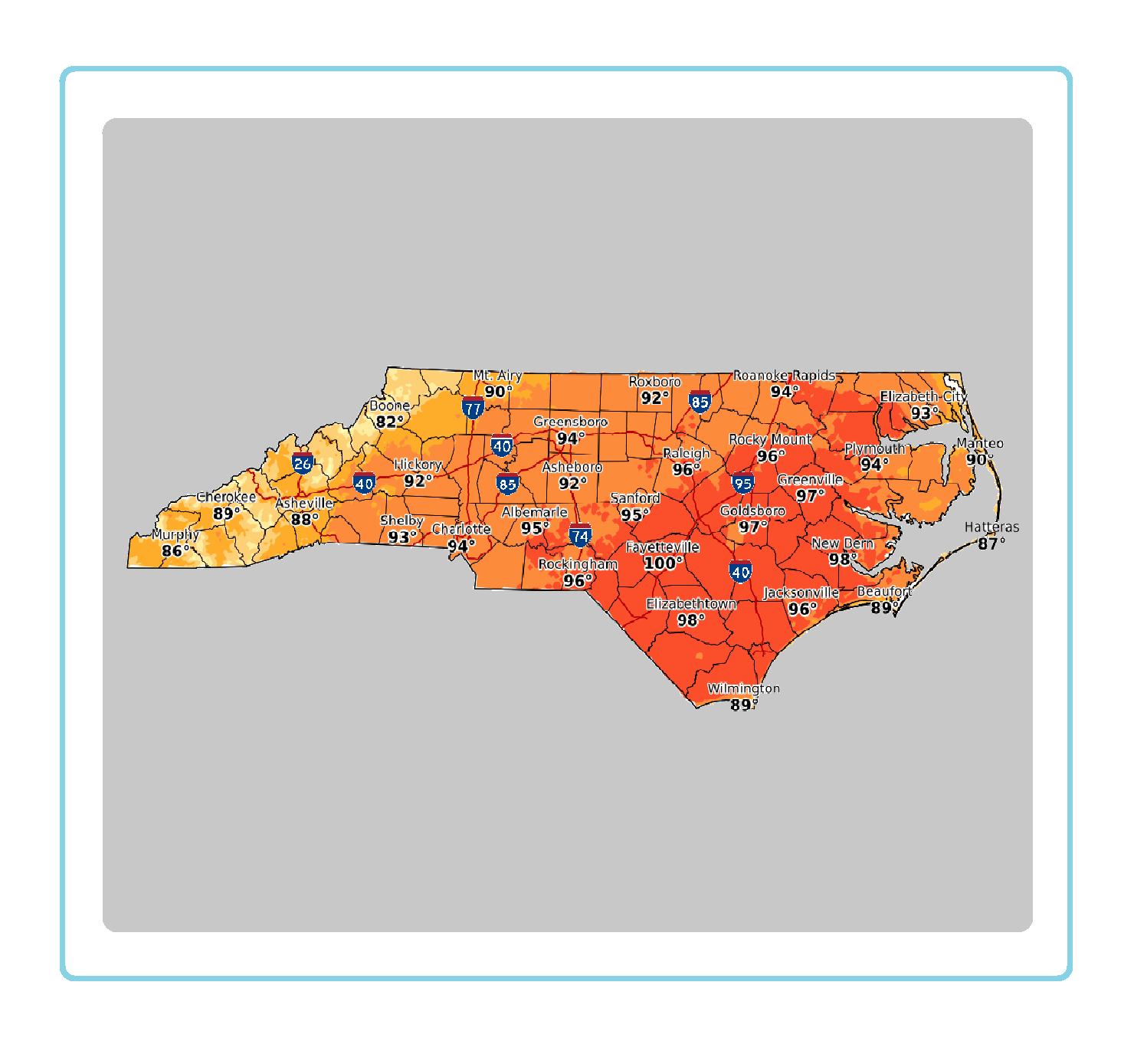 Statewide Maps
 Forecaster Discussion