Binghamton, NY
Weather Forecast Office
Latest aviation discussion:
.AVIATION /08Z SUNDAY THROUGH THURSDAY/...
Moist airmass over the region with showers and thunderstorms
developing early this morning and heading into RME and SYR
around 3 AM (07Z) and eventually into ITH just before sunrise.
It is unknown at this time how far southeast this line of
thunderstorms will push, but storms may also impact ELM and BGM
later this morning, but confidence was just too low to add to
the forecast at this time. Fog and low ceiling will likely also
be a concern at ELM and AVP through the early morning hours.

Flight conditions gradually improve to VFR later this morning or
early afternoon.

Outlook...

Sunday...VFR. Isolated restrictions from showers and
thunderstorms possible, mainly southern half of the area.

Monday through Wednesday...Mainly VFR.

Wednesday night into Thursday...Restrictions with showers and
thunderstorms possible.
|
This discussion and more can be found in the Area Forecast Discussion.
Aviation Forecasts
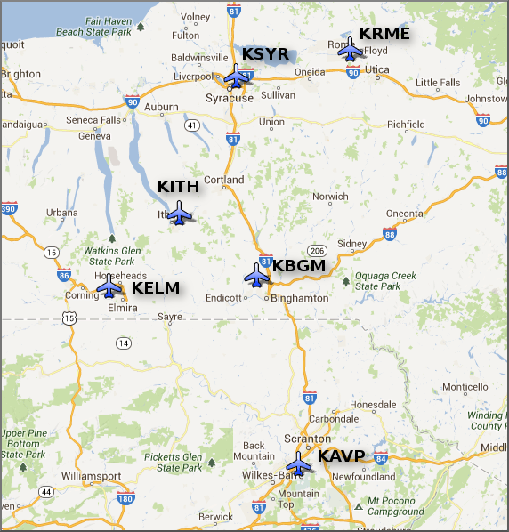
The National Weather Service Office in Binghamton, NY has responsibility for six Terminal Aerodrome Forecasts or TAFs in Central New York and Northeast Pennsylvania.
Click on a site on the map below to view the latest TAF.
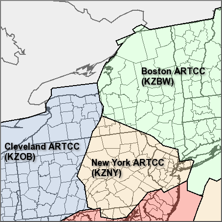
Center Weather Service Unit Products
Three Center Weather Service Unit (CWSU) cover the NWS Binghamton, NY County Warning Area. Click on the map or one of the links below the map to go to the corresponding CSWU website.
Text links...
Decoded/Raw Text
| Location | Sky/Weather | Temperature | Dewpoint Temperature | Relative Humidity | Wind | Pressure | Remarks |
| Binghamton, NY | PTCLDY | 71 | 70 | 96 | S7 | 29.95S | |
| Cortland, NY | CLOUDY | 73 | 68 | 83 | W9 | 29.93R | |
| Dansville, NY | TSTM | 73 | 68 | 84 | CALM | 29.91R | |
| Elmira, NY | PTCLDY | 71 | 69 | 93 | CALM | 29.90S | FOG |
| Ithaca, NY | MOCLDY | 72 | 71 | 97 | W9G16 | 29.93R | |
| Monticello, NY | NOT AVBL | ||||||
| Penn Yan, NY | HVY RAIN | 69 | 67 | 93 | W13G22 | 29.91R | VSB 1 |
| Rome, NY | CLOUDY | 68 | 67 | 96 | E5 | 29.87F | |
| Syracuse, NY | LGT RAIN | 75 | 71 | 87 | S5 | 29.85S | |
| Hazleton, PA | N/A | 72 | 70 | 94 | S3 | 30.02F | |
| Scranton, PA | CLOUDY | 74 | 72 | 93 | SW5 | 29.96S | FOG |
| 500 AM EDT SUN JUN 30 2024 | |||||||
METAR Request form via the Aviation Weather Center. Raw and decoded observations.
​Surface Weather Maps
Miscellaneous
Current Hazards
Briefing
Drought
Fire Weather
Graphical Hazardous Weather Outlook
Hurricanes
Local Outlook
River Flooding
Space Weather
Thunderstorms
Winter
Current Conditions
Air Quality
Local Storm Reports
Observation (list)
Observations (Map)
More Surface Observations
Rainfall
Satellite
More Satellite
Upper Air
Radar
Local Enhanced Radar
Local Standard Radar (low bandwidth)
Regional/National Standard Radar (low bandwidth)
More Radar
Forecasts
Activity Planner
Aviation
Detailed View
Fire Weather
Forecaster's Discussion
Hourly View
Map View
Model Data
Space Weather
Text Products
User Defined Area Forecast
Rivers and Lakes
River Forecasts (Map)
River Observations (Map)
River Forecast Centers
River Forecasts (Text)
Ensemble River Guidance
Current Streamflow
Flood Inundation Maps
River Monitor
US Dept of Commerce
National Oceanic and Atmospheric Administration
National Weather Service
Binghamton, NY
32 Dawes Drive
Johnson City, NY 13790
(607) 729-1597
Comments? Questions? Please Contact Us.

