The interaction of a cold front moving across the area and remnants of Hurricane Jeanne produced locally heavy rainfall across parts of central New York and Northeast Pennsylvania September 28-29, 2004.
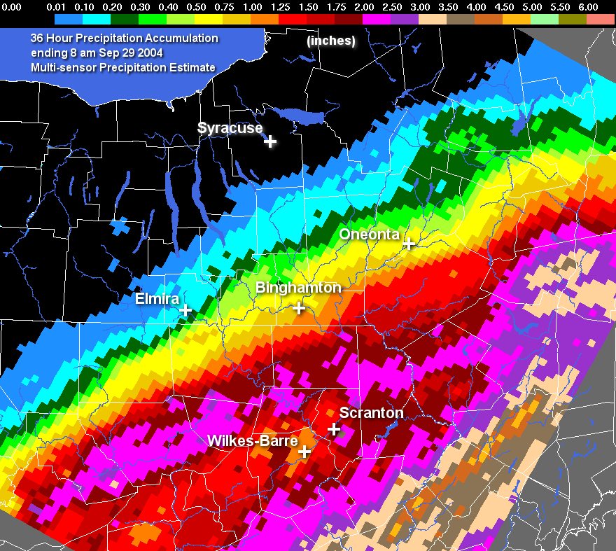
The graphic shown above is the Multisensor Precipitation Estimate, otherwise known as MPE data, The multisensors involved at this time are radar and precipitation gages. The image below is a 36 hour total ending on September 29, 2004 at 8 AM EDT.
When using MPE data, it is important to remember it is vulnerable to the same inaccuracies that can be caused by either radar or precipitation gages. For radar, problems would be: freezing or frozen precipitation, low topped convection, bright banding, the reflectivity/rainfall relationship in use, calibration of the radar, radar location and elevation, range degradation, and the radar's effective coverage. For precipitation gages, problems come from freezing precipitation, windy conditions, gage siting, undermeasurement by tipping bucket gages in high intensity rainfall, and gage maintenance.
| Spotter and Cooperative Observer Reports | ||
|---|---|---|
| New York | ||
| Location | Storm Total | |
| Broome | ||
| Binghamton | 0.56 | |
| Whitney Point Dam | 0.33 | |
| Windsor | 1.40 | |
| Chemung | ||
| Big Flats | 0.04 | |
| Chemung | 0.42 | |
| Elmira Airport | 0.08 | |
| Elmira Observer | 0.11 | |
| Chenango | ||
| Bainbridge | 0.70 | |
| Norwich | 0.26 | |
| Sherburne | 0.14 | |
| Delaware | ||
| Lordville | 2.24 | |
| Delhi 2 SE | 1.61 | |
| Deposit | 1.54 | |
| East Sidney | 0.82 | |
| Fishs Eddy | 1.92 | |
| Walton 2 | 1.51 | |
| Sullivan | ||
| Bloomingburg 2 SW | 2.25 | |
| Monticello | 2.3 | |
| Claryville | 1.8 | |
| Callicoon 2 | 1.5 | |
| Roscoe | 1.9 | |
| Liberty | 2.63 | |
| Pennsylvania | ||
| Location | Storm Total | |
| Bradford | ||
| Bentley Creek | 0.40 | |
| Canton | 1.39 | |
| Columbia Crossroads | 0.44 | |
| East Smithfield | 0.56 | |
| Franklindale | 1.28 | |
| Hugo Corners | 2.60 | |
| Litchfield | 0.68 | |
| Le Raysville | 1.40 | |
| Monroeton | 1.46 | |
| Orwell | 1.14 | |
| Troy | 0.72 | |
| Troy | 0.45 | |
| Towanda | 1.43 | |
| Lackawanna | ||
| Big Shiney Mtn | 0.76 | |
| Aylesworth | 1.29 | |
| WCDL Radio Tower | 2.44 | |
| Moscow | 1.88 | |
| Moscow | 1.84 | |
| Merli-Sarnowski | 1.91 | |
| Parker Street Bridge | 1.60 | |
| Scrub Oak | 4.00 | |
| Luzerne | ||
| Avoca | 1.58 | |
| Francis E Walter Dam | 2.06 | |
| Glenn Summit | 1.32 | |
| Hazelton | 1.98 | |
| Bear Creek | 1.72 | |
| Nescopeck Pass | 1.64 | |
| Shickshinny | 2.02 | |
| West Hazelton | 2.32 | |
| Pike | ||
| Buckhorn Ridge | 1.20 | |
| Edgemere | 2.04 | |
| Dingman | 2.2 | |
| Greentown | 2.1 | |
| Germantown | 2.12 | |
| Hawley 1 E | 1.93 | |
| Matamoras | 2.44 | |
| Susquehanna | ||
| Thompson | 1.85 | |
| Susquehanna | 2.01 | |
| Forest City | 1.9 | |
| Hop Bottom | 1.9 | |
| Lawton | 1.91 | |
| Stillwater Lake | 2.29 | |
| Wayne | ||
| Aldenville | 2.26 | |
| Dreher | 2.28 | |
| Equinunk | 1.80 | |
| Dyberry Creek | 1.95 | |
| Honesdale | 1.92 | |
| Milanville | 1.92 | |
| Milanville 2 | 2.18 | |
| Pleasant Mount 1 W | 2.55 | |
| Prompton Dam | 1.93 | |
| Prompton | 1.85 | |
| Reining Pond | 1.68 | |
| Rileyville | 2.12 | |
| Shehawken Lake | 1.08 | |
| Wyoming | ||
| Noxen | 1.24 | |
| Tunkhannock | 2.21 | |

