NWS Damage Survey for Tompkins County NY and Cortland County NY Tornado Event of August 7th 2023.
Survey Summary:
A tornado touched down near the intersection of Route 38 and Purvis Road in far eastern Tompkins County. It then moved northeastward through a mostly wooded area from Harford to Virgil. The most widespread damage was found along Clute Road where several trees were uprooted and snapped and a large shed/storage building had its roof partially torn off and partially collapsed. The tornado then brought down more trees along a property along Stafford Road before continuing northeastward to West River Road. Several snapped and uprooted trees were observed at residences along this road. The last observed damage was in a wooded area between West River Road and the Tioughnioga River and this is where the tornado lifted.
The National Weather Service would like to thank the Town of Virgil Fire Chief and area residents for their assistance during this survey.
NOTE: The information in this statement is preliminary and subject to change pending final review of the event and publication in NWS Storm Data.
Below shows a two panel display showing NWS Binghamton radar base reflectivity on the left and storm relative motion (velocity) on the right. The loop is from 04:56 PM EDT (2056 UTC) to 05:50 PM EDT (2150 UTC) on August 07, 2023. Note the hook echo in the reflectivity part of the loop that moves through Virgil, NY. Click on the image for a larger view.
NWS Damage Survey for Susquehanna County PA and Broome County Tornado Event of August 7th 2023.
Survey Summary:
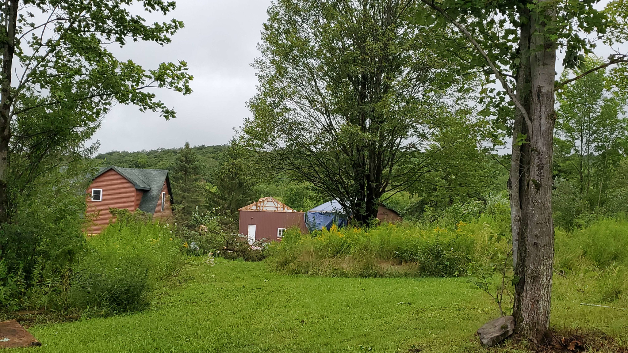
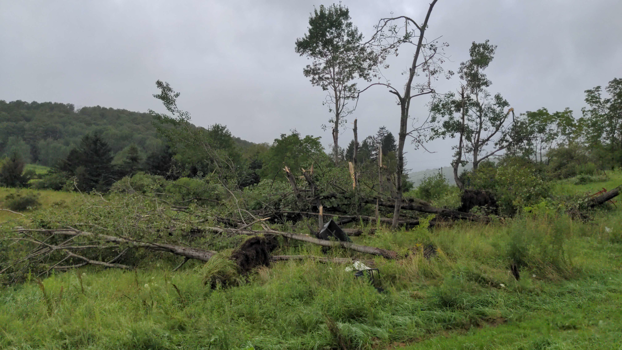
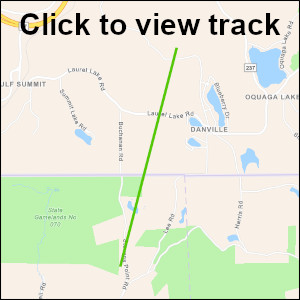
A tornado touched down near the intersection of Mountain Road and Stevens Point Road in Harmony Township northeast Susquehanna County at 625 PM EDT Monday August 7th 2023. The tornado snapped and uprooted many trees on Stevens Point Road as the tornado tracked north-northeast roughly along Stevens Point Road. The tornado then weakened as it crossed the PA - NY border with only some minor tree damage along Laurel Lake Road in the Town of Sanford, Broome County. The tornado then strengthened as it crossed over a hill and hit Kenyon Hill Road. There was a residence on Kenyon Hill Road in the Town of Sanford that bore the brunt of the damage with windows blown out, shingles blown off the roof and numerous trees snapped and uprooted. A shed was moved about 100 feet with a couple boats on a pond lofted in the air. The tornado reached its maximum intensity of 90 mph in this location before lifting over the next hillside.
NOTE: The information in this statement is preliminary and subject to change pending final review of the event and publication in NWS Storm Data.
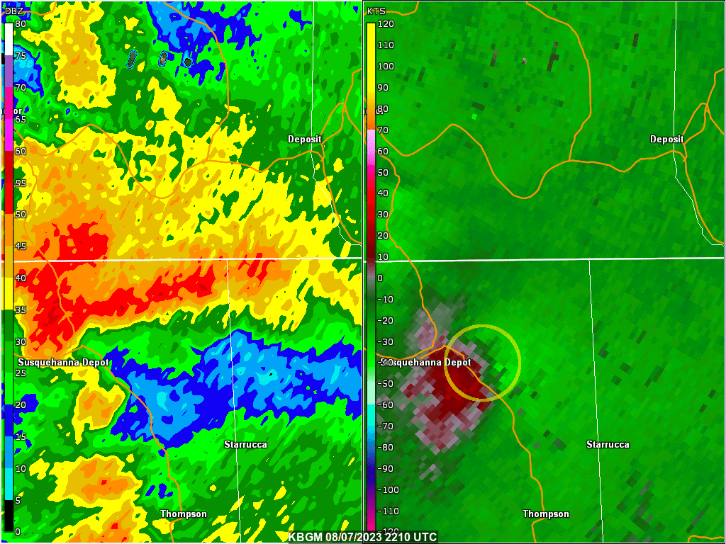
Below shows a two panel display showing NWS Binghamton radar base reflectivity on the left and storm relative motion (velocity) on the right. The loop is from 06:10 PM EDT (2210 UTC) to 06:51 PM EDT (2251 UTC) on August 07, 2023. The yellow circle shows the mesocyclone that produced the tornado. Click on the image for a larger view.
NWS Damage Survey for Munnsville, NY
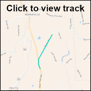
Survey Summary:
A tornado touched down on Bear Path Road then moved northeast onto Morris Road before lifting. Numerous trees had branches snapped in different directions. Damage to a door on a shed also occurred. We want to thank Madison county Emergency Management and local residents for assistance with this survey. Video was also provided. After further investigation, we modified the rating from an EF-1 to an EF-0.
NOTE: The information in this statement is preliminary and subject to change pending final review of the event and publication in NWS Storm Data.
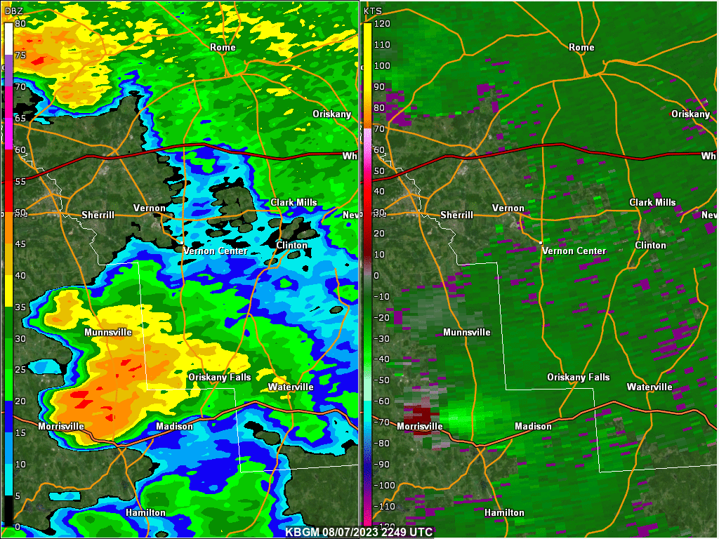
Below shows a two panel display showing NWS WSR-88D at Montague, NY radar base reflectivity on the left and storm relative motion (velocity) on the right. The loop is from 06:49 PM EDT (2249 UTC) to 07:38 PM EDT (2328 UTC) on August 07, 2023. Click on the image for a larger view. This is the same radar loop as in the Vernon tab.
MWG/BJG/DK
NWS Damage Survey for Vernon, NY
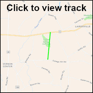
Survey Summary:
A tornado touched down onto College Hill Road with numerous downed and uprooted trees. Damage continued northward onto a local golf course where additional trees were downed in multiple directions. The tornado then lifted once it reached Seneca turnpike. We want to thank Oneida County Emergency Management, NY State Emergency Management, local residents and the highway department for the assistance with this survey. Also, several videos came in as well from the general public for this tornado.
NOTE: The information in this statement is preliminary and subject to change pending final review of the event and publication in NWS Storm Data.
Below shows a two panel display showing NWS WSR-88D at Montague, NY radar base reflectivity on the left and storm relative motion (velocity) on the right. The loop is from 06:49 PM EDT (2249 UTC) to 07:38 PM EDT (2328 UTC) on August 07, 2023. Click on the image for a larger view. This is the same radar loop as in the Munnsville tab.
MWG/BJG/DK
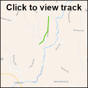
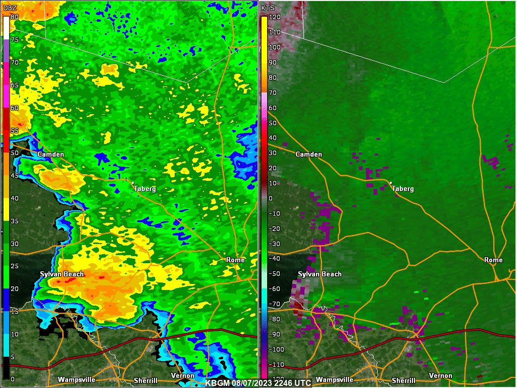
NWS Damage Survey near Taberg, NY
Survey Summary:
A tornado touched down on Coal Hill Road taking down some tree branches then moved northward reaching it`s widest width on Grission Lane where numerous trees were uprooted and downed. The tornado also damaged a roof. The tornado then lifted as it reached the intersection of Slater road and Coal Hill Road. We want to thank Oneida county and NY state emergency management along with local residents for assistance with this survey. Video information was also provided to assist with this survey.
NOTE: The information in this statement is preliminary and subject to change pending final review of the event and publication in NWS Storm Data.
Below shows a two panel display showing NWS WSR-88D at Montague, NY radar base reflectivity on the left and storm relative motion (velocity) on the right. The loop is from 06:46 PM EDT (2246 UTC) to 07:42 PM EDT (2342 UTC) on August 07, 2023. Click on the image for a larger view.
MWG/BJG/DK
Observations are collected from a variety of sources with varying equipment and exposures. We thank all volunteer weather observers for their dedication. Not all data listed are considered official. Click on the image for a larger view.

Public Information Statement National Weather Service Binghamton NY 1019 AM EDT Tue Aug 8 2023 ... 24hr PRECIPITATION REPORTS... Location Amount Time/Date Provider ...New York... ...Broome County... HARPURSVILLE 1.30 in 1000 AM 08/08 CWOP Conklin 1.14 in 1009 AM 08/08 CWOP Windsor 8.0 SE 1.14 in 0700 AM 08/08 COCORAHS Windsor 1.13 in 1000 AM 08/08 CWOP 1.8 SE Windsor (SNOTEL) 1.10 in 0530 AM 08/08 MESOWEST WHITNEY POINT 0.85 in 1010 AM 08/08 CWOP BINGHAMTON 0.78 in 1000 AM 08/08 CWOP Binghamton 0.72 in 1000 AM 08/08 CWOP Binghamton 0.69 in 1010 AM 08/08 NYSM Vestal Center VFD 2 0.60 in 1000 AM 08/08 CWOP Belden 0.57 in 1010 AM 08/08 NYSM Whitney Point 1.7 SSE 0.56 in 0600 AM 08/08 COCORAHS Kopernik Observatory 0.54 in 1000 AM 08/08 CWOP Binghamton 0.46 in 1000 AM 08/08 CWOP Binghamton 0.44 in 1000 AM 08/08 CWOP Binghamton 1.3 ENE 0.43 in 0830 AM 08/08 COCORAHS Vestal 0.38 in 1000 AM 08/08 CWOP Vestal 0.37 in 1000 AM 08/08 CWOP Vestal 3.2 E 0.37 in 0700 AM 08/08 COCORAHS BINGHAMTON 0.33 in 1000 AM 08/08 CWOP Binghamton 2.9 NNE 0.33 in 0700 AM 08/08 COCORAHS Binghamton 0.32 in 1000 AM 08/08 CWOP Vestal 0.31 in 0958 AM 08/08 CWOP Lisle 0.30 in 1005 AM 08/08 CWOP ...Cayuga County... Scipio Center 1.70 in 1010 AM 08/08 NYSM Auburn 1.63 in 1009 AM 08/08 CWOP Cayuga 4.0 NNE 1.56 in 0700 AM 08/08 COCORAHS Scipio Center 3.0 S 1.43 in 0722 AM 08/08 COCORAHS Cayuga 1.7 NE 1.25 in 0700 AM 08/08 COCORAHS Venice Center 1.14 in 1005 AM 08/08 AWS 2.0 N Cayuga 1.06 in 0640 AM 08/08 COOP Auburn 1.05 in 1009 AM 08/08 AWS Auburn 5.1 WNW 1.05 in 0700 AM 08/08 COCORAHS Auburn 8.3 SSE 0.62 in 0600 AM 08/08 COCORAHS Aurora 2.4 N 0.43 in 0650 AM 08/08 COCORAHS ...Chemung County... Horseheads 2.7 SSE 0.87 in 0700 AM 08/08 COCORAHS 1.0 NE West Elmira 0.78 in 0700 AM 08/08 COOP Elmira 0.75 in 1010 AM 08/08 NYSM West Elmira 0.5 SSE 0.58 in 0700 AM 08/08 COCORAHS Elmira Airport 0.39 in 0953 AM 08/08 ASOS ...Chenango County... Greene 0.68 in 1010 AM 08/08 CWOP Afton 0.41 in 1008 AM 08/08 CWOP ...Cortland County... Freetown 1.0 NE 0.39 in 0700 AM 08/08 COCORAHS Cincinnatus 0.36 in 1010 AM 08/08 NYSM ...Delaware County... Roxbury 1.43 in 1010 AM 08/08 NYSM Long Eddy 6.5 NNE 1.36 in 0800 AM 08/08 COCORAHS Margaretville 1.23 in 1000 AM 08/08 CWOP Deposit 1.17 in 1010 AM 08/08 NYSM Andes 1.14 in 1010 AM 08/08 NYSM Roxbury 1.05 in 1005 AM 08/08 CWOP Hobart 4.8 ESE 1.01 in 0700 AM 08/08 COCORAHS Hancock 1.0 W 0.95 in 0700 AM 08/08 COCORAHS Walton 0.60 in 1010 AM 08/08 NYSM Harpersfield 0.34 in 1010 AM 08/08 NYSM Afton 0.32 in 1009 AM 08/08 CWOP Franklin 0.32 in 1009 AM 08/08 CWOP Delhi 6.6 WNW 0.32 in 0700 AM 08/08 COCORAHS ...Madison County... 2 N Sullivan 1.10 in 1010 AM 08/08 AWS Munnsville 0.85 in 1000 AM 08/08 CWOP 0.7 SE Erieville (SNOTEL) 0.80 in 0515 AM 08/08 MESOWEST Chittenango 2.1 ESE 0.72 in 0801 AM 08/08 COCORAHS Morrisville 6 S 0.60 in 0515 AM 08/08 COOP Erieville 0.52 in 1005 AM 08/08 CWOP Morrisville 0.44 in 1010 AM 08/08 NYSM Cazenovia 2.9 SE 0.30 in 0700 AM 08/08 COCORAHS ...Oneida County... Camden 2.53 in 1010 AM 08/08 NYSM Point Rock 0.6 SE 2.49 in 0700 AM 08/08 COCORAHS Otter Lake 2.47 in 1008 AM 08/08 CWOP Woodgate 1.61 in 1010 AM 08/08 NYSM Durhamville 3.5 NNW 1.09 in 0700 AM 08/08 COCORAHS Sylvan Beach 1.6 NW 1.00 in 0700 AM 08/08 COCORAHS Verona Beach 0.71 in 0945 AM 08/08 HADS Rome 4.8 SSE 0.67 in 0700 AM 08/08 COCORAHS Westmoreland 4 N 0.67 in 0700 AM 08/08 COOP Westmoreland 0.61 in 1010 AM 08/08 NYSM Griffiss Airfield 0.60 in 0953 AM 08/08 AWOS Holland Patent 1.1 WNW 0.57 in 0700 AM 08/08 COCORAHS Westmoreland 0.55 in 1002 AM 08/08 CWOP Deansboro 0.51 in 1005 AM 08/08 CWOP Remsen 0.43 in 1008 AM 08/08 AWS Whitesboro 0.2 W 0.40 in 0700 AM 08/08 COCORAHS 1.3 E Delta Lake 0.34 in 0945 AM 08/08 HADS ...Onondaga County... Liverpool 6.1 NNW 7.01 in 0730 AM 08/08 COCORAHS Brewerton 1.5 ESE 5.31 in 0800 AM 08/08 COCORAHS Brewerton Lock 23 4.80 in 0700 AM 08/08 COOP Camillus 3.94 in 1010 AM 08/08 CWOP Clay 4.6 NW 3.93 in 0800 AM 08/08 COCORAHS Baldwinsville 3.3 NE 3.71 in 0721 AM 08/08 COCORAHS Clay 3.61 in 1004 AM 08/08 CWOP Jordan 3.26 in 1010 AM 08/08 NYSM Clay 3.05 in 1008 AM 08/08 CWOP Baldwinsville 3.5 NE 3.04 in 0800 AM 08/08 COCORAHS Cicero 2.72 in 1005 AM 08/08 CWOP Syracuse Airport 2.17 in 1004 AM 08/08 ASOS Phoenix 1.93 in 1000 AM 08/08 CWOP Fairmount 1.31 in 1000 AM 08/08 CWOP Syracuse 2.7 S 1.25 in 0730 AM 08/08 COCORAHS 1 S Bennetts Corners 1.16 in 1005 AM 08/08 AWS Skaneateles 0.8 NNW 1.12 in 0700 AM 08/08 COCORAHS Skaneateles 1.09 in 1000 AM 08/08 CWOP Camillus 2.3 SSE 1.08 in 0700 AM 08/08 COCORAHS Fayetteville 1.07 in 1010 AM 08/08 NYSM Skaneateles 9.1 SE 1.06 in 0700 AM 08/08 COCORAHS FAYETTEVILLE 1.01 in 1006 AM 08/08 CWOP Syracuse 0.94 in 1005 AM 08/08 CWOP Syracuse 0.91 in 1005 AM 08/08 AWS Marcellus 0.88 in 1007 AM 08/08 CWOP Westvale 2.3 SSW 0.86 in 0930 AM 08/08 COCORAHS Manlius 0.84 in 1005 AM 08/08 CWOP Camillus 1.0 W 0.81 in 0700 AM 08/08 COCORAHS Camillus 0.80 in 1000 AM 08/08 CWOP Tully 0.79 in 1007 AM 08/08 CWOP 1 WNW Marcellus 0.77 in 1005 AM 08/08 AWS Jamesville 0.72 in 1005 AM 08/08 CWOP Marcellus 0.70 in 1002 AM 08/08 CWOP Otisco 0.63 in 0956 AM 08/08 CWOP Minoa 0.52 in 1003 AM 08/08 CWOP Tully 0.42 in 1010 AM 08/08 NYSM Apulia Station 0.39 in 1009 AM 08/08 CWOP Tully 0.37 in 1001 AM 08/08 CWOP ...Otsego County... 1.2 N Cooperstown 0.80 in 1200 AM 08/08 COOP Hartwick 0.61 in 0421 AM 08/08 COCORAHS Richfield Springs 4.6 SSE 0.30 in 0700 AM 08/08 COCORAHS ...Schuyler County... Dundee 6.2 E 1.40 in 0700 AM 08/08 COCORAHS Reading Center 1.15 in 0700 AM 08/08 COCORAHS Gabriels Junction 0.93 in 1010 AM 08/08 CWOP Mecklenburg 1.2 SE 0.84 in 0600 AM 08/08 COCORAHS Tyrone 0.65 in 1010 AM 08/08 NYSM Bolter Creek 0.54 in 0912 AM 08/08 RAWS Arnot Lodge 0.50 in 0500 AM 08/08 COOP 2.1 N Swartwood (SNOTEL) 0.50 in 0500 AM 08/08 MESOWEST Mecklenburg 4 SW 0.50 in 0700 AM 08/08 COOP Burdett 0.50 in 1010 AM 08/08 NYSM Odessa 0.35 in 1005 AM 08/08 AWS ...Seneca County... LODI 1.57 in 1005 AM 08/08 CWOP Seneca Falls 1.13 in 1007 AM 08/08 CWOP Waterloo 0.51 in 1010 AM 08/08 NYSM Romulus 0.33 in 1009 AM 08/08 AWS ...Steuben County... 2.8 NW Prattsburg 1.34 in 1000 AM 08/08 ALERT Addison 1.29 in 1006 AM 08/08 CWOP Canisteo 0.92 in 1006 AM 08/08 CWOP Addison 0.86 in 1010 AM 08/08 NYSM 1.8 SW Corning 0.84 in 1005 AM 08/08 ALERT Gang Mills 0.84 in 1008 AM 08/08 RAWS 1.1 SW Corning 0.80 in 0700 AM 08/08 COOP 3.9 NW Jasper 0.80 in 0830 AM 08/08 COOP 3.9 NW Jasper (SNOTEL) 0.80 in 0830 AM 08/08 MESOWEST 2.8 E Erwins 0.69 in 1008 AM 08/08 HADS Corning 1.3 SE 0.69 in 0630 AM 08/08 COCORAHS Corning 2.9 N 0.67 in 0700 AM 08/08 COCORAHS Hartsville 0.65 in 1010 AM 08/08 NYSM Savona 4.7 S 0.61 in 0700 AM 08/08 COCORAHS CORNING 0.55 in 1005 AM 08/08 CWOP South Corning 4.7 S 0.52 in 0900 AM 08/08 COCORAHS Bath 1.3 E 0.51 in 0900 AM 08/08 COCORAHS 2.7 W Bradford 0.48 in 1000 AM 08/08 ALERT Branchport 0.43 in 1000 AM 08/08 CWOP Avoca 0.41 in 1009 AM 08/08 AWS NORTH HORNELL 0.31 in 1005 AM 08/08 CWOP ...Sullivan County... 2 SW Claryville 2.20 in 0400 AM 08/08 COOP 3.4 E Willowemoc (SNOTEL) 2.20 in 0400 AM 08/08 MESOWEST Eldred 1.27 in 1010 AM 08/08 NYSM Grahamsville 1.18 in 1006 AM 08/08 CWOP Woodbourne 1.04 in 1010 AM 08/08 NYSM North Branch 1.02 in 1010 AM 08/08 NYSM Barryville 0.99 in 1009 AM 08/08 CWOP Monticello 0.84 in 1006 AM 08/08 CWOP Livingston Manor 0.69 in 1000 AM 08/08 CWOP Jeffersonville 0.31 in 1009 AM 08/08 AWS ...Tioga County... 1.7 N Newark Valley 0.30 in 0815 AM 08/08 COOP 1.7 N Newark Valley (SNOTEL) 0.30 in 0815 AM 08/08 MESOWEST ...Tompkins County... Slaterville Springs 1.25 in 1000 AM 08/08 CWOP CORNELL HTRC ITHACA 13 E 1.07 in 0100 AM 08/08 HADS Ithaca 2.6 NW 0.73 in 0800 AM 08/08 COCORAHS Freeville 1.5 NE 0.58 in 0700 AM 08/08 COCORAHS Ithaca Airport 0.56 in 0958 AM 08/08 AWOS Dryden 0.55 in 1007 AM 08/08 CWOP Groton 0.5 NW 0.51 in 0700 AM 08/08 COCORAHS 2 NE Dryden 0.49 in 1005 AM 08/08 AWS Dryden 0.48 in 1000 AM 08/08 CWOP Newfield Hamlet 4.3 S 0.48 in 0900 AM 08/08 COCORAHS Ithaca 0.47 in 1005 AM 08/08 CWOP 0.7 E Freeville 0.44 in 0800 AM 08/08 COOP Freeville 3.7 W 0.39 in 0700 AM 08/08 COCORAHS Ithaca 0.38 in 1005 AM 08/08 CWOP Berkshire 0.36 in 1009 AM 08/08 CWOP Groton 3.2 SSW 0.32 in 0700 AM 08/08 COCORAHS Ithaca 0.5 N 0.31 in 0800 AM 08/08 COCORAHS ...Yates County... Penn Yan 5.1 NNW 0.49 in 0600 AM 08/08 COCORAHS Penn Yan 0.48 in 0953 AM 08/08 ASOS Middlesex 3.5 S 0.44 in 0900 AM 08/08 COCORAHS ...Pennsylvania... ...Bradford County... Canton 2.07 in 0800 AM 08/08 COOP 1 SSE Rome 1.06 in 1005 AM 08/08 AWS Wysox 1.04 in 1008 AM 08/08 CWOP Roaring Creek 0.47 in 0949 AM 08/08 RAWS Sayre 5.4 E 0.30 in 0800 AM 08/08 COCORAHS ...Lackawanna County... Richmondale 1.36 in 1006 AM 08/08 CWOP Vandling 0.1 NNE 1.32 in 0700 AM 08/08 COCORAHS Thornhurst 0.80 in 1000 AM 08/08 CWOP Sterling - 22 0.59 in 0700 AM 08/08 COCORAHS Archbald 0.56 in 1007 AM 08/08 CWOP Moscow 2.7 W 0.54 in 0700 AM 08/08 COCORAHS Mayfield 0.53 in 1008 AM 08/08 CWOP Clarks Green 0.5 N 0.53 in 0930 AM 08/08 COCORAHS Taylor 0.48 in 1009 AM 08/08 CWOP Madison Township 0.46 in 1000 AM 08/08 CWOP Archbald 1.6 SW 0.43 in 0800 AM 08/08 COCORAHS Peckville 0.42 in 1009 AM 08/08 CWOP Thornhurst 0.38 in 0948 AM 08/08 RAWS Old Forge 0.37 in 1005 AM 08/08 AWS Moosic 0.36 in 1010 AM 08/08 CWOP ...Luzerne County... Beach Haven 0.8 E 1.33 in 0222 AM 08/08 COCORAHS CONYNGHAM 1.28 in 1005 AM 08/08 CWOP Conyngham 3.9 NE 1.15 in 0700 AM 08/08 COCORAHS Bear Creek Township 0.95 in 1008 AM 08/08 CWOP Front Royal 0.81 in 1008 AM 08/08 CWOP Nescopeck Pass 0.68 in 1010 AM 08/08 CWOP Harveys Lake 1.5 W 0.68 in 0700 AM 08/08 COCORAHS Hazleton 0.57 in 1005 AM 08/08 CWOP Shickshinny 0.55 in 1010 AM 08/08 CWOP Hanover Township 0.53 in 1000 AM 08/08 CWOP Penn Lake 0.46 in 1008 AM 08/08 CWOP Duryea 0.3 SE 0.34 in 0700 AM 08/08 COCORAHS Glen Lyon 0.31 in 1010 AM 08/08 CWOP ...Pike County... Greentown 1.65 in 1000 AM 08/08 CWOP Shohola 1.48 in 1009 AM 08/08 CWOP Milford 8.7 NW 1.11 in 0700 AM 08/08 COCORAHS 2 NNW Dingmans Ferry 1.10 in 0926 AM 08/08 AWS Camp William Penn 0.82 in 0950 AM 08/08 RAWS Loch Lomond 0.51 in 0942 AM 08/08 RAWS Tafton 0.50 in 1010 AM 08/08 CWOP 2 NE Kimbles 0.43 in 1010 AM 08/08 AWS ...Susquehanna County... 1.2 S Uniondale 1.91 in 1000 AM 08/08 COOP Montrose 0.4 ENE 1.73 in 0800 AM 08/08 COCORAHS Forest City 0.89 in 1009 AM 08/08 AWS Harford 1.4 NNE 0.57 in 0800 AM 08/08 COCORAHS New Milford 0.55 in 1006 AM 08/08 CWOP MONTROSE 0.31 in 1006 AM 08/08 CWOP ...Wayne County... 1.6 W Pleasant Mount 2.58 in 0815 AM 08/08 COOP Pleasant Mount 2.31 in 1008 AM 08/08 CWOP Starrucca 0.88 in 1005 AM 08/08 CWOP 2 S Abrahamsville 0.51 in 1005 AM 08/08 AWS Hawley - 15 0.48 in 0700 AM 08/08 COCORAHS PROMPTON - 25 0.46 in 0700 AM 08/08 COCORAHS Hawley 0.45 in 1000 AM 08/08 HADS Honesdale 3.7 SSW 0.44 in 0700 AM 08/08 COCORAHS Honesdale 0.42 in 1008 AM 08/08 CWOP Starrucca - 27 0.40 in 0700 AM 08/08 COCORAHS Dyberry - 19 0.38 in 0650 AM 08/08 COCORAHS Beach Lake 3.3 ENE 0.36 in 0700 AM 08/08 COCORAHS ...Wyoming County... Falls 0.90 in 1010 AM 08/08 CWOP Tunkhannock 0.81 in 1000 AM 08/08 CWOP Tunkhannock 0.80 in 1000 AM 08/08 CWOP Tunkhannock 0.47 in 0805 AM 08/08 COOP Forkston 0.34 in 1000 AM 08/08 CWOP
|
For reference: Enhanced Fujita Scale classifies tornadoes into the following categories:
A microburst is a convective downdraft with an affected outflow area of less than 2 1/2 miles wide and peak winds lasting less than 5 minutes. Microbursts may induce dangerous horizontal and vertical wind shears, which can adversely affect aircraft performance and cause property damage. Straight-line winds are generally any wind that is not associated with rotation, used mainly to differentiate them from tornadic winds. |
Addition Information