Severe thunderstorms moved through parts of Central New York and northeast Pennsylvania on July 18, 2011. The storms produced spotty damage to trees and power lines, and large hail. One of the storms moved over the Greater Binghamton Airport and the National Weather Service. The observing unit at the airport measured the wind speeds with this severe storm.
The Automated Surface Observing Systems or ASOS which measures several different weather elements, including wind speed, recorded a maximum gust of 68 MPH with the passage of the storm.
| Date | Time UTC | Time EDT | Wind Direction | Wind Speed (MPH) | Wind Gust (MPH) |
| 07-18-2011 | 20:53:00 | 4:53 PM | West Southwest | 5.8 | 0 |
| 07-18-2011 | 21:53:00 | 5:53 PM | Northwest | 5.8 | 0 |
| 07-18-2011 | 22:53:00 | 6:53 PM | North Northwest | 6.9 | 0 |
| 07-18-2011 | 23:53:00 | 7:53 PM | North | 5.8 | 0 |
| 07-19-2011 | 00:53:00 | 8:53 PM | North | 5.8 | 0 |
| 07-19-2011 | 01:15:00 | 9:15 PM | Northeast | 5.8 | 0 |
| 07-19-2011 | 01:36:00 | 9:36 PM | North Northeast | 44.9 | 67.9 |
| 07-19-2011 | 01:41:00 | 9:41 PM | South Southeast | 15 | 67.9 |
| 07-19-2011 | 01:48:00 | 9:48 PM | East | 8.1 | 31.1 |
| 07-19-2011 | 01:51:00 | 9:51 PM | Calm | Calm | 0 |
| 07-19-2011 | 01:53:00 | 9:53 PM | Variable | 3.5 | 0 |
| 07-19-2011 | 02:17:00 | 10:17 PM | South | 4.6 | 0 |
| 07-19-2011 | 02:53:00 | 10:53 PM | Calm | Calm | 0 |
| 07-19-2011 | 03:53:00 | 11:53 PM | Calm | Calm | 0 |
Below is a two panel radar display. On the right is a 0.5 Base Reflectivity, and the left is 0.5 Base Velocity from the NWS Binghamton, NY WSR-88D. This loop is from 08:45 PM EDT to 10:22 PM EDT, July 18, 2011.
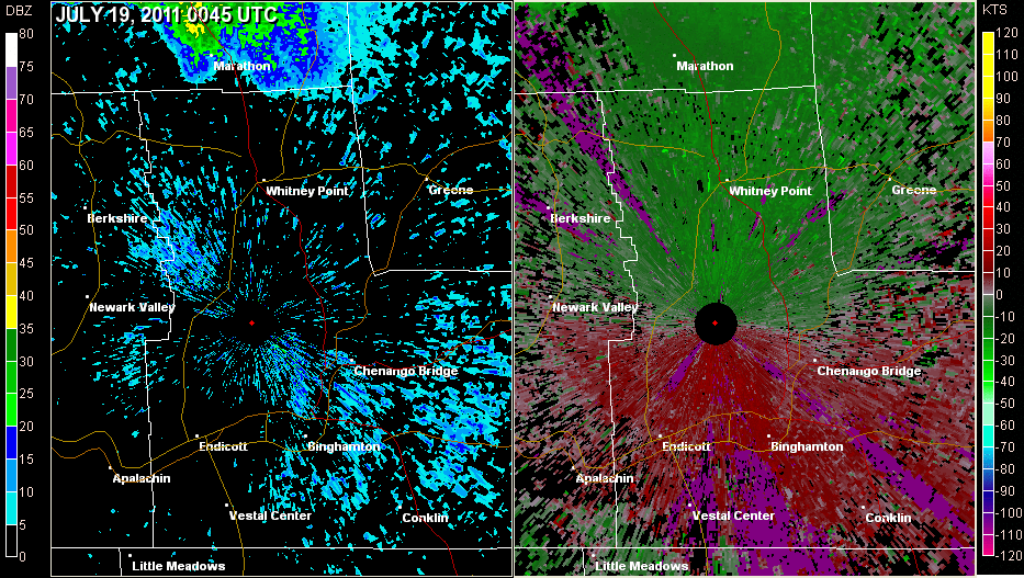
At the center of each panel there is a large black dot with a red dot in the middle. This is where the radar is located. The time of each image is in the upper left corner. At 0127 UTC or 9:27 PM EDT there is a green area moving towards the radar. The radar is estimating wind speeds of 58 to 63 MPH or 50 to 55 knots towards the radar.
This is a base reflectivity radar loop from the National Weather Service radar Binghamton, NY. This loop shows thunderstorms moving across parts of central NY and northeast PA from 02:00 PM EDT (18:00 UTC) July 18, 2011 through 01:59 AM EDT July 19, 2011 (05:59 UTC).
For reference:

