NWS Damage Survey Confirms Straight-Line Winds to 100 mph for July 24th, 2023 Thunderstorm Event in Enfield, NY.
Survey Summary:
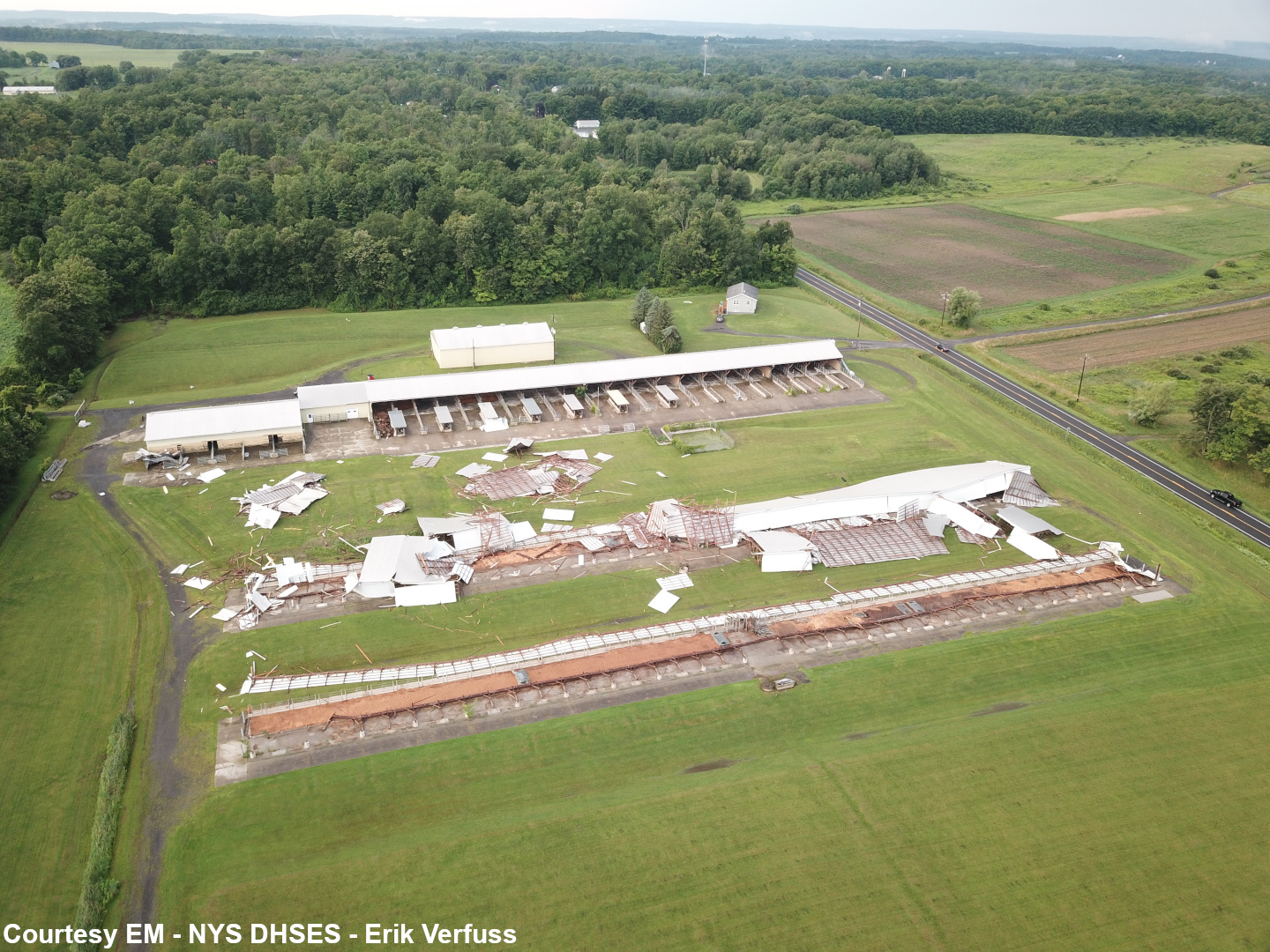
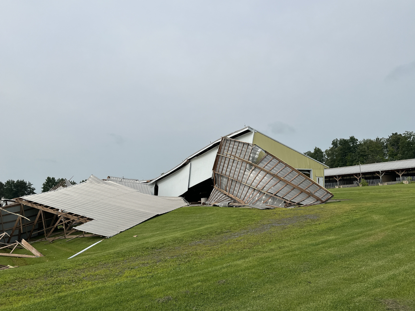
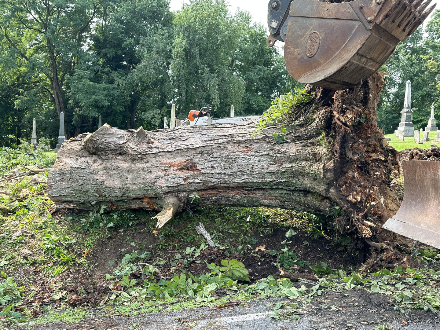
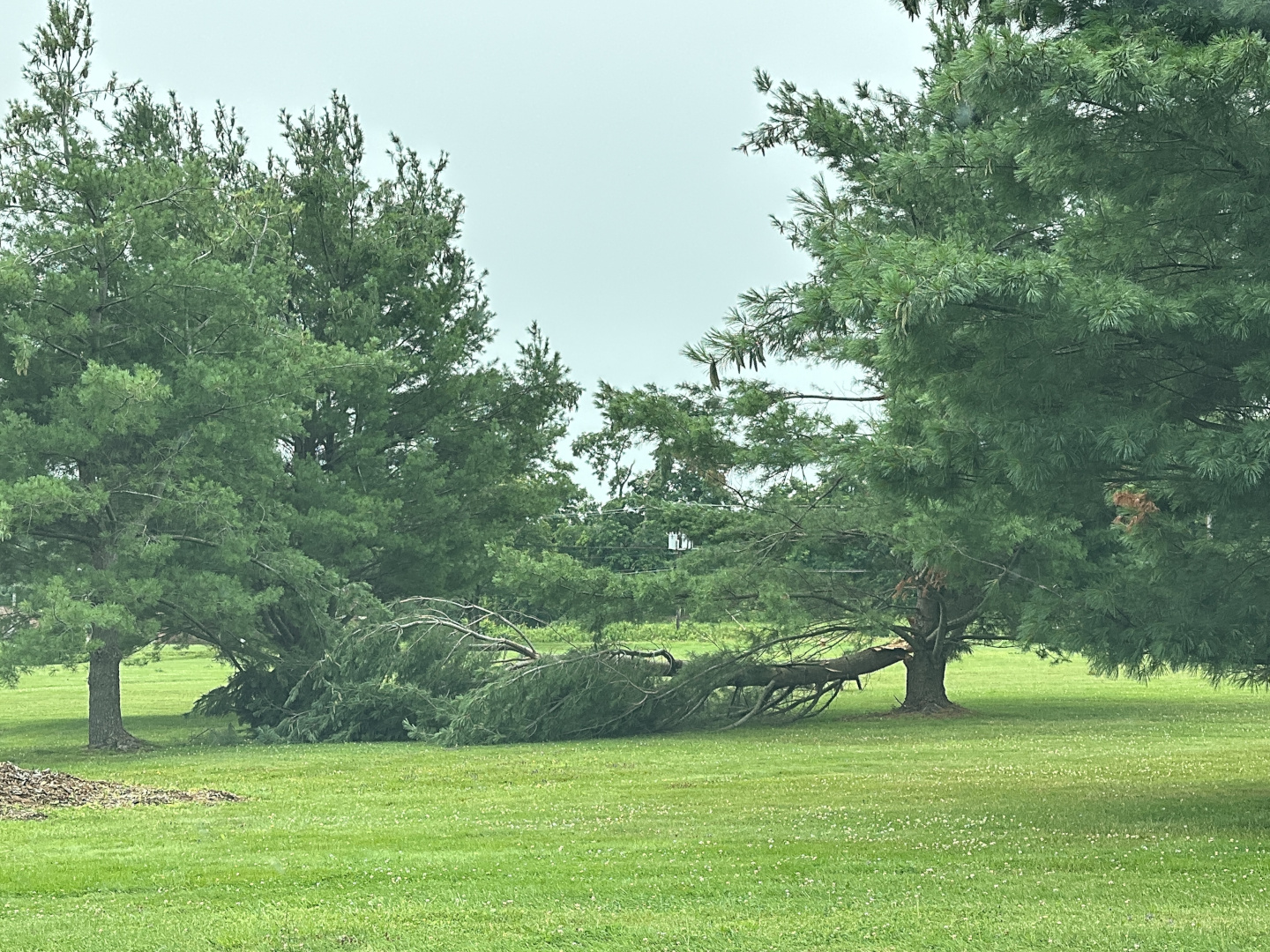
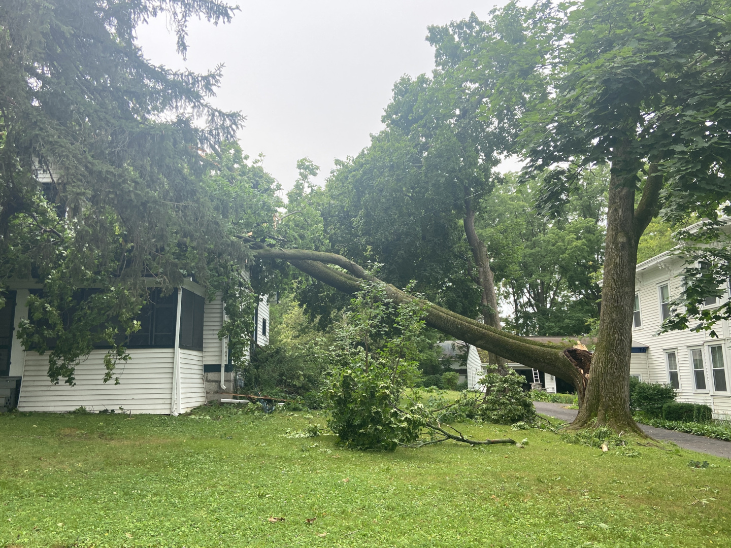
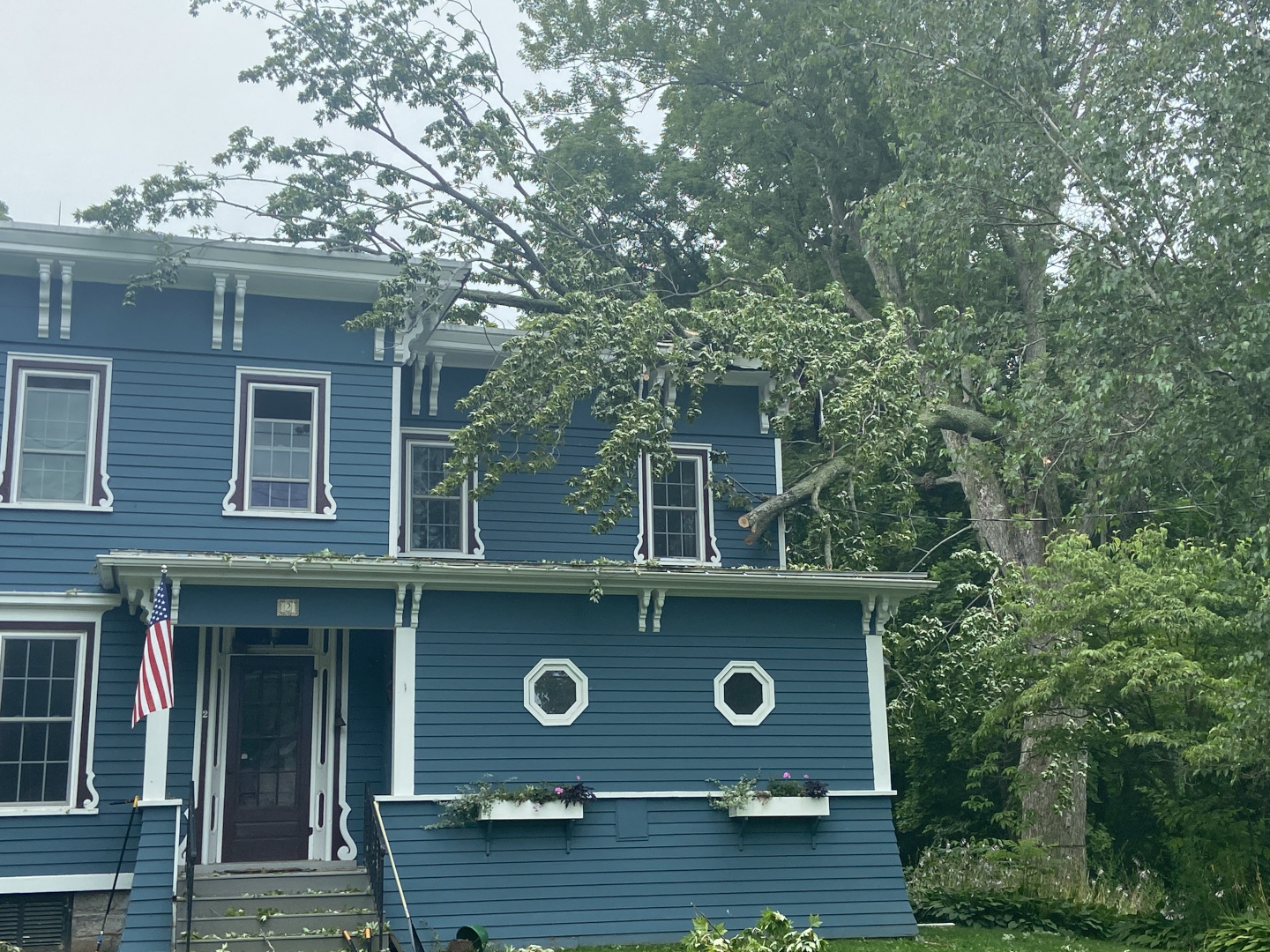
A thunderstorm that moved through Tompkins County on the evening of Monday, July 24th has been determined to have produced a microburst that destroyed two barns, uprooted trees, and caused a divergent path of downed trees in the direction of eastward storm motion. The epicenter of the microburst was most likely at the intersection of Hayts Road & Sheffield Road in Enfield, NY, where two barns were lifted off the foundation, mostly destroyed and displaced northwestward. Progressing eastward on Hayts Road, uprooted trees and multiple downed trees in the eastward direction were observed. These damage indicators began to have diverging directions both northeast- and southeast-ward, indicating the spread of a wind pool from a microburst.
KL/DJN
Some damage images. Click for a larger view.
 |
 |
 |
 |
NWS Damage Survey Confirms Straight-Line Winds to 80 mph for the July 24th, 2023 Severe Thunderstorm Wind Event in Union Springs, NY.
Survey Summary:
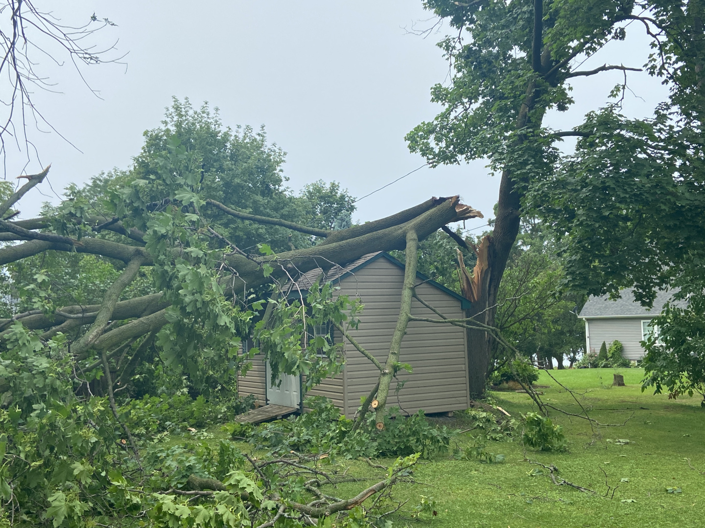
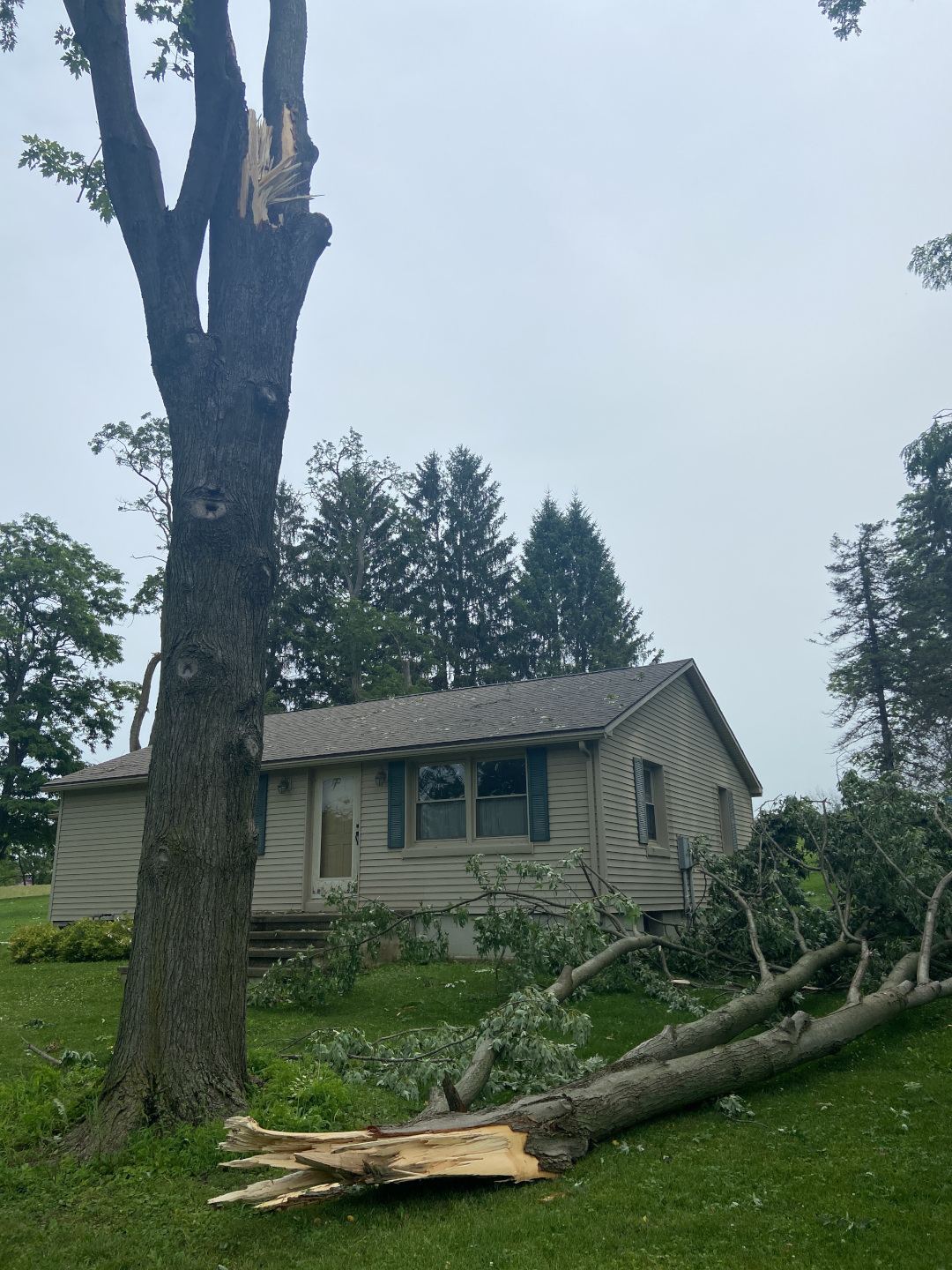
The core of a severe thunderstorm descended right onto Cayuga Lake around 224 PM EDT on July 24, 2023, blasting the immediate eastern shore with a microburst of 70 to 80 mph winds at Union Springs. Numerous trees had large branches snapped and a few were uprooted right at the edge of the lake, also causing downed wires and a power pole. At least two houses, and one shed sustained moderate roof damage from large branches falling on them. Several others had more cosmetic or minor damage from small branches. There were also downed trees, a broken metal sign, and minor boat damage at a marina. The property manager there even observed a miniature seiche of sorts, with the power of the wind causing water to surge a bit into the marina during the storm, then it flowed back out shortly after.
The National Weather Service thanks affected residents, Union Springs Public Works personnel, the Union Springs Mayor, and Cayuga County Emergency Management for their assistance during this survey.
MDP
Some damage images. Click for a larger view.
 |
 |
 |
 |
Preliminary Local Storm Report

..TIME...   ...EVENT...      ...CITY LOCATION...     ...LAT.LON...
..DATE...   ....MAG....      ..COUNTY LOCATION..ST.. ...SOURCE....
            ..REMARKS..

1004 PM     Tstm Wnd Dmg     2 SSE Susquehanna       41.91N 75.59W
07/24/2023                   Susquehanna        PA   911 Call Center

            Tree down blocking the road. Time estimated
            from radar.

1028 PM     Tstm Wnd Dmg     3 SSW Hallstead         41.92N 75.77W
07/24/2023                   Susquehanna        PA   911 Call Center

            Tree down blocking the road. Time estimated
            from radar.

1043 PM     Tstm Wnd Dmg     New Milford             41.88N 75.73W
07/24/2023                   Susquehanna        PA   911 Call Center

            Trees and wires down. Time estimated from
            radar.

0531 PM     Tstm Wnd Dmg     2 W Northwest Ithaca    42.47N 76.57W
07/24/2023                   Tompkins           NY   Emergency Mngr

            Barns collapsed with a lot debris, numerous
            trees down. Hayts Road and Sheffield Road in
            Enfield. Time estimated from radar.

0540 PM     Tstm Wnd Dmg     2 W Northwest Ithaca    42.47N 76.57W
07/24/2023                   Tompkins           NY   NWS Storm Survey

            A thunderstorm that moved through Tompkins
            County on the evening of Monday, July 24th
            has been determined to have produced a
            microburst that destroyed two barns,
            uprooted trees, and caused a divergent path
            of downed trees in the direction of eastward
            storm motion. The epicenter of the
            microburst was most likely at the
            intersection of Hayts Road & Sheffield Road
            in Enfield, NY, where two barns were lifted
            off the foundation, mostly destroyed and
            displaced northwestward. Progressing
            eastward on Hayts Road, uprooted trees and
            multiple downed trees in the eastward
            direction were observed. These damage
            indicators began to have diverging
            directions both northeast- and
            southeast-ward, indicating the spread of a
            wind pool from a microburst.

0542 PM     Tstm Wnd Dmg     1 NE Ithaca             42.45N 76.50W
07/24/2023                   Tompkins           NY   911 Call Center

            Tree down on a house on North Aurora St.

0544 PM     Tstm Wnd Dmg     1 SE Northwest Ithaca   42.46N 76.53W
07/24/2023                   Tompkins           NY   911 Call Center

            Trees and wires down near the corner of
            Bundy Rd and Trumansburg Rd.

0602 PM     Tstm Wnd Dmg     Ithaca                  42.45N 76.50W
07/24/2023                   Tompkins           NY   911 Call Center

            Tree on a house.

0603 PM     Tstm Wnd Dmg     2 W South Hill          42.41N 76.53W
07/24/2023                   Tompkins           NY   911 Call Center

            Wire on roadway.

0653 PM     Tstm Wnd Dmg     1 WNW West Candor       42.22N 76.43W
07/24/2023                   Tioga              NY   911 Call Center

            Corrects previous tstm wnd dmg report from 1
            WNW West Candor. Tree down blocking the
            road. Time estimated from radar.

0800 PM     Flood            Spencer                 42.22N 76.49W
07/24/2023                   Tioga              NY   911 Call Center

            water over the road. Also in Candor. Time
            estimated.

1239 PM     Tstm Wnd Dmg     2 SSW Glen Spey         41.44N 74.84W
07/25/2023                   Sullivan           NY   911 Call Center

            Wires down on the roadway via county
            dispatch. Time estimated from radar.

0130 PM     Tstm Wnd Dmg     1 SE Yorkville          43.11N 75.26W
07/24/2023                   Oneida             NY   911 Call Center

            Wires down on Ney Avenue. Time estimated
            from radar.

0135 PM     Tstm Wnd Dmg     2 WSW Floyd             43.20N 75.39W
07/24/2023                   Oneida             NY   911 Call Center

            Tree down across one lane of traffic at New
            Floyd Road and Rickmeyer Road. Time
            estimated from radar.

0138 PM     Tstm Wnd Dmg     3 ESE Stittville        43.21N 75.23W
07/24/2023                   Oneida             NY   911 Call Center

            Trees and wires down. Coombs Road and Glass
            Factory Road. Time estimated from radar.

0148 PM     Flood            Floyd                   43.22N 75.35W
07/24/2023                   Oneida             NY   911 Call Center

            4-6 inches of water in roadway.

0148 PM     Tstm Wnd Dmg     2 NE Holland Patent     43.26N 75.23W
07/24/2023                   Oneida             NY   911 Call Center

            Tree down on wires on Pierce Road. TIme
            estimated from radar.

0203 PM     Tstm Wnd Dmg     2 E Delta Lake          43.28N 75.41W
07/24/2023                   Oneida             NY   911 Call Center

            Tree down on Townline Road. Time estimated
            from radar.

0230 PM     Tstm Wnd Dmg     5 NNE Woodgate          43.59N 75.13W
07/24/2023                   Oneida             NY   911 Call Center

            Tree down on Lakeview Road. Time estimated
            from radar.

0130 PM     Tstm Wnd Dmg     Canastota               43.08N 75.76W
07/24/2023                   Madison            NY   911 Call Center

            Multiple trees and wires down. Time
            estimated from radar.

0226 PM     Lightning        2 S Canastota           43.06N 75.76W
07/24/2023                   Madison            NY   911 Call Center

            *** 3 INJ ***
            3 people struck by lightning in the town of
            Lincoln. Time provided by 911 dispatch
            center.

0520 PM     Tstm Wnd Dmg     Peterboro               42.97N 75.67W
07/24/2023                   Madison            NY   911 Call Center

            Multiple trees and wires down in Smithfield.
            Time estimated from radar.

0224 PM     Tstm Wnd Dmg     Union Springs           42.85N 76.69W
07/24/2023                   Cayuga             NY   NWS Storm Survey

            Updates prior report. NWS survey confirms a
            70 to 80 mph microburst blasted the eastern
            shore of Cayuga Lake at Union Springs.
            Numerous trees had large branches snapped
            and a few were uprooted. At least 2 houses,
            and 1 shed sustained moderate roof damage
            from large branches falling on them.

0451 PM     Tstm Wnd Dmg     Whitney Point           42.33N 75.97W
07/24/2023                   Broome             NY   911 Call Center

            Trees and wires down. Time estimated from
            radar.

0542 PM     Tstm Wnd Dmg     1 E Union Center        42.15N 76.04W
07/24/2023                   Broome             NY   911 Call Center

            Tree down on Twist Run Road. Time estimated
            from radar.

0545 PM     Tstm Wnd Dmg     2 NNE Endwell           42.15N 76.01W
07/24/2023                   Broome             NY   911 Call Center

            Tree down on Sally Piper Road. Time
            estimated from radar.

0735 PM     Tstm Wnd Dmg     1 SW Castle Creek       42.22N 75.93W
07/24/2023                   Broome             NY   911 Call Center

            tree down on Brooks Road. Time estimated
            from radar.
NOTE: The information in this statement is preliminary and subject to change pending final review of the event and publication in NWS Storm Data.
Addition Information

