Please click on one of the tabs below to read a summary of the storms in each of these areas.
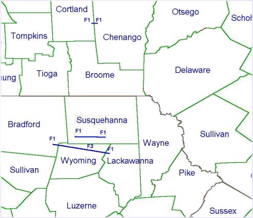
Cortland to Chenango County Summary
National Weather Service Post Storm Damage Survey for Tuesday June 2, 1998 across Cayuga, Cortland, and Chenango Counties.
A thunderstorm developed east of Penn Yan around 600 PM EDT Tuesday evening and moved eastward through Seneca county. The storm strengthened as it moved into Cayuga county and became severe when straight line winds downed trees and wires in Niles and Moravia townships. A funnel cloud and hail up to 1 1/2 inches in diameter were also reported.
Reports of funnel clouds continued as the storm moved across Cortland county from Homer through Taylor although additional tree damage was sporadic. The storm then rapidly intensified and produced a small tornado to the south of telephone road. The damage was consistent with an F1 tornado with a path length of 100 yards and a width of 60 yards. Straight line winds of 80 to 100 MPH also downed large trees on Telephone Road, Knickerbocker Road, and Cincinnatus Road.
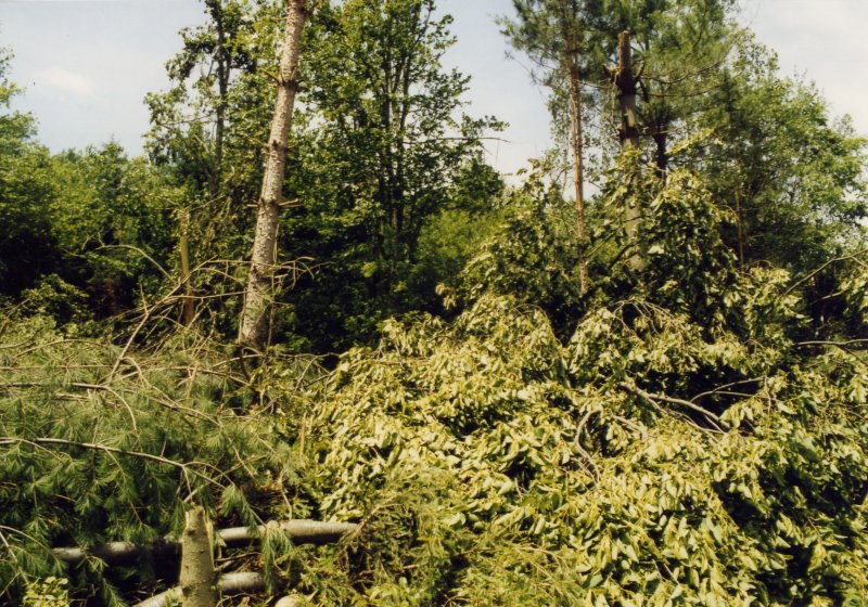
The small tornado then skipped over the Cortland county line into Chenango county and produced another damage path 1/4 mile long by 100 yards wide across Bently Road. Many trees were snapped in half and some pines had their bark stripped off. Most of the damage is consistent with a category F1 tornado with winds of 73 to 112 MPH.
The tornado quickly dissipated but the storm continued to produce funnel clouds as it tracked across Chenango county. Thunderstorm winds caused spotty additional damage to trees as the storm moved over Norwich and into Otsego county.
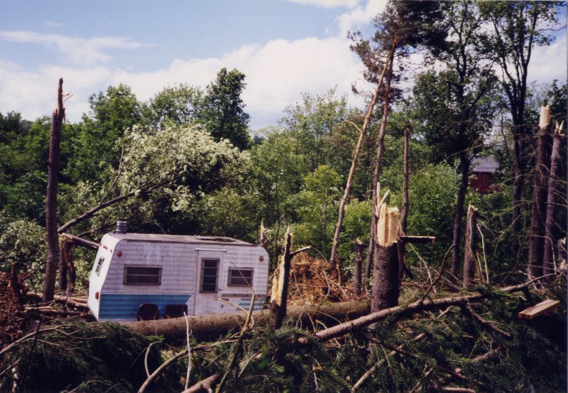 Trees down near Bently Road. |
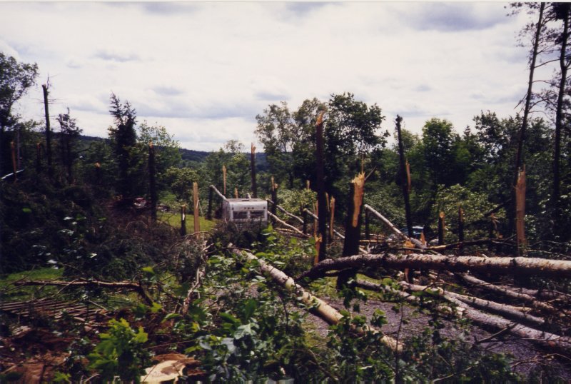 Another view of trees down near camper near Bently Road. |
 Large tree down on Telephone Road. |
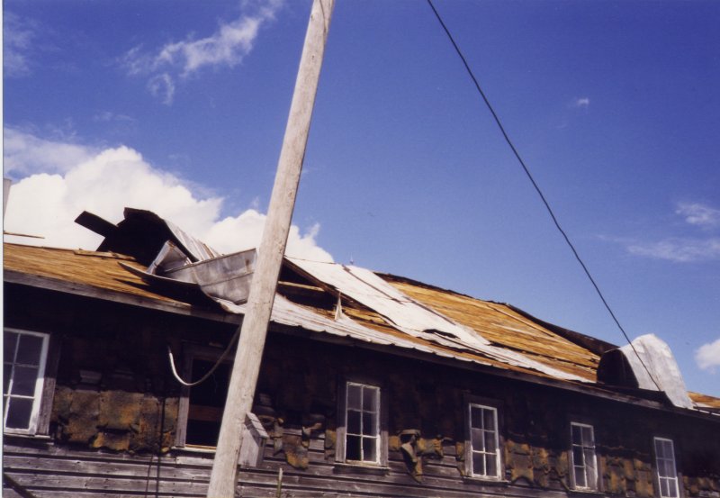 Damage to structure near Knickerbocker Road. |
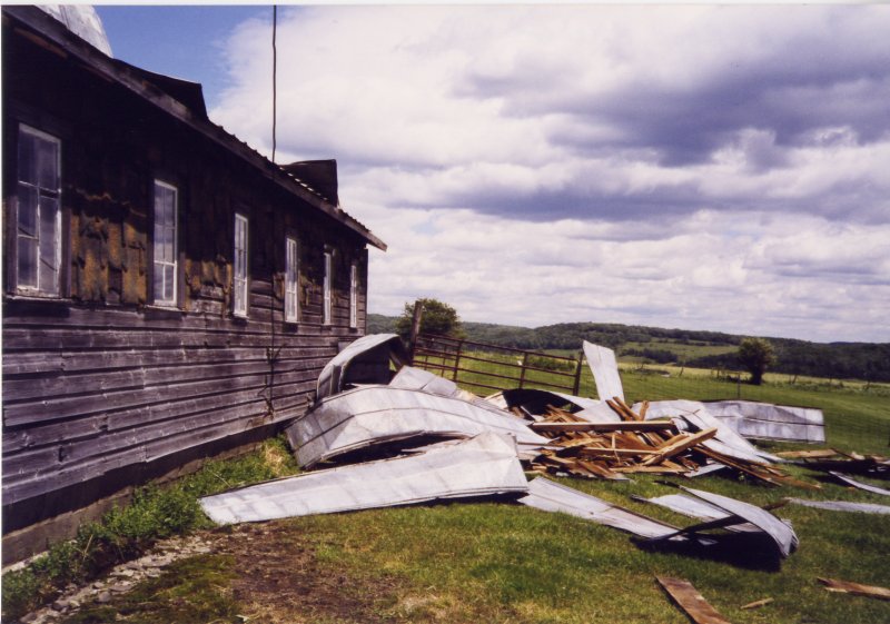 Another view of damage to structure near Knickerbocker Road. |
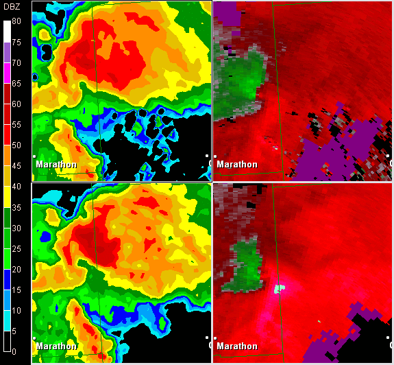
| This is a short radar loop showing a "hook echo" moving just north of Marathon, NY in Cortland county. On the left is base reflectivity and on the right is the corresponding storm relative motion. The storm relative motion shows an area of rotation occurring in the same area as the "hook echo". |
 |
Bradford County Summary
A severe thunderstorm developed over western Bradford county and ultimately spawned a tornado over Terry township. Eyewitness reports and damage surveys indicate that the twister first touched down just east of Robwood mountain and west of State Route 2015 around 945 pm EDT. At this location, a mobile home was knocked off its foundation about 8 feet and sustained heavy damage on its front side. Fortunately for the two occupants who were inside the structure when the tornado struck, a farm vehicle, pickup truck, and storage shed all acted to stop the forward momentum of the trailer and prevent it from rolling down a fairly steep hill another 100 yards or so ahead. Another storage building just north of the mobile home was severely damaged with its roof completely torn off and some metal beams removed from the siding. As the tornadic cell continued eastward, the funnel appeared to elevate for a time as sporadic damage at tree top level was seen downstream for about a mile and a half. Once the storm crossed just east of Billetts Pond, it descended to flatten a large barn. Debris was scattered in all directions from where the barn once stood with a large section of the roof structure thrown 200-300 yards downwind. Meanwhile, a newly built home with a large rear deck only 150 yards or so from the large barn sustained relatively minor damage. What little damage was incurred appeared to be caused by flying wood strips from the barn. Further downstream, the tornado again apparently lifted back towards the cloud base with a discontinuous path of tree damage from that point east-southeastward across the Wyoming county line. Within Terry township, the tornado was rated as F1 intensity.
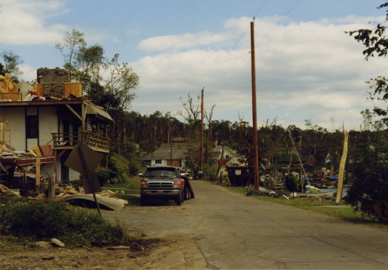
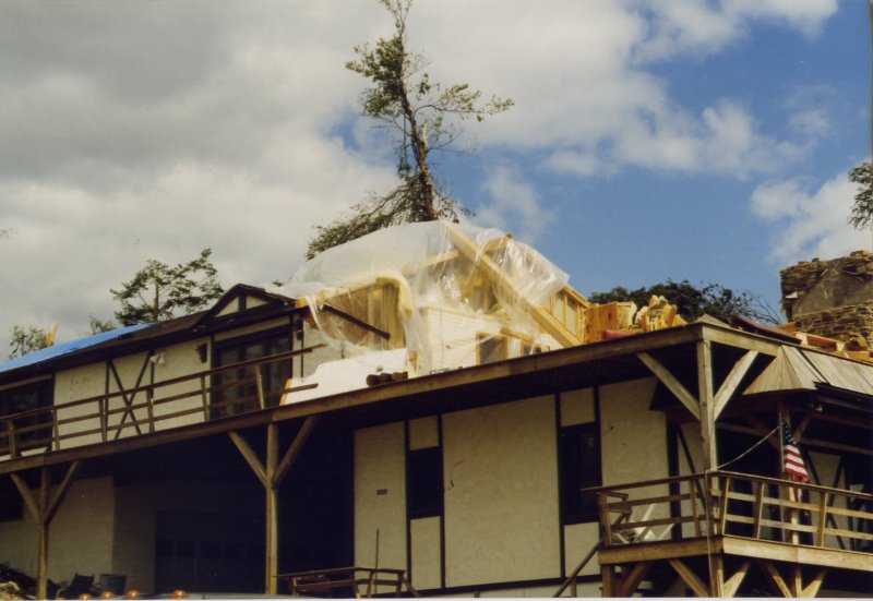
Aerial surveys indicate that intervals of tree damage occurred in northern Wyoming county from Braintrim eastward to just north of Meshoppen and then to near Valentine Hill on the border of Lemon township. This damage was primarily in the form of twisted off tree sections at canopy level and also some uprooted trees on hilltop areas. Between 1010 and 1015 pm EDT, the tornado lowered again down the east side of Valentine Hill, skipped across the far north end of Stevens Lake, and carved a path over a small hill just west of Lake Carey. Several residences along this path had heavy tree damage and minor siding and roof damage to their homes. The twister then seemed to turn temporarily towards the south and cross a portion of the long axis of Lake Carey. It was here within this small vacation community that the most severe damage occurred along with loss of life. Eyewitness accounts indicate that the tornado crossed State Route 1003 (a small causeway across the short axis of the lake in an east-west orientation) at about 1020 pm EDT. Every structure located along this narrow strip of land crossing Lake Carey either sustained substantial damage or was completely leveled. It was here where two fatalities occurred as an elderly woman and her grandson were literally sucked out of the second floor of a house and thrown into an adjacent building. Every nearby tree was snapped off, uprooted, or otherwise toppled in chaotic patterns.
At that point, the tornado made a jog to the left and resumed its eastward course. It crossed over State Route 1005, which parallels the eastern end of Lake Carey, then skipped up over a small hill.
Again, heavy damage was inflicted upon homes in the path of the tornado both along the east end of the lake and also going up the hill. A dozen or more small boats which were anchored along the eastern end of the lake were thrown up out of the water and onto the shoreline. One home going up the hill was reduced to only its foundation and a portion of the back wall. Massive tree damage continued to be evident with a swath of trees cut down in a narrow path going up over the hill and down its eastern side towards East Lemon township. A total of 42 homes in and around Lake Carey suffered considerable damage or were totally decimated. Preliminary damage estimates in excess of one million dollars have been quoted by county emergency management officials. The character of damage near Lake Carey indicates that the tornado strengthened to F3 intensity.
Click for a larger view.
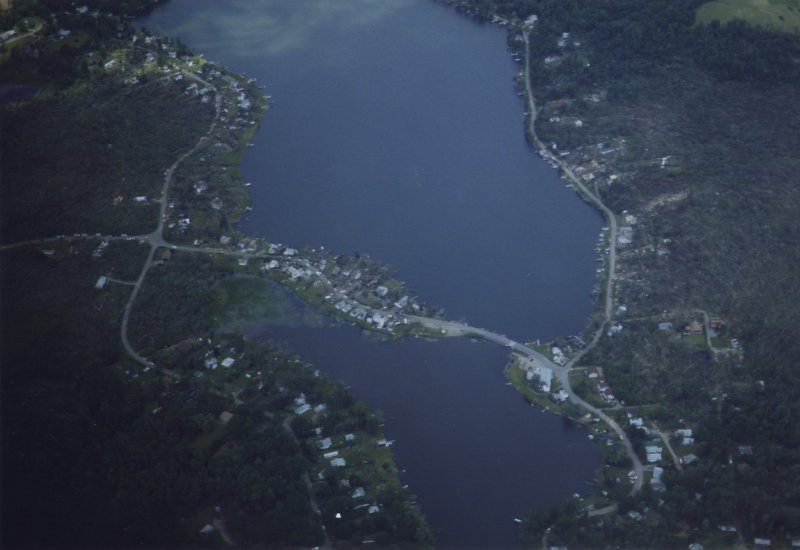 Aerial photo of the Lake Carey, PA area. |
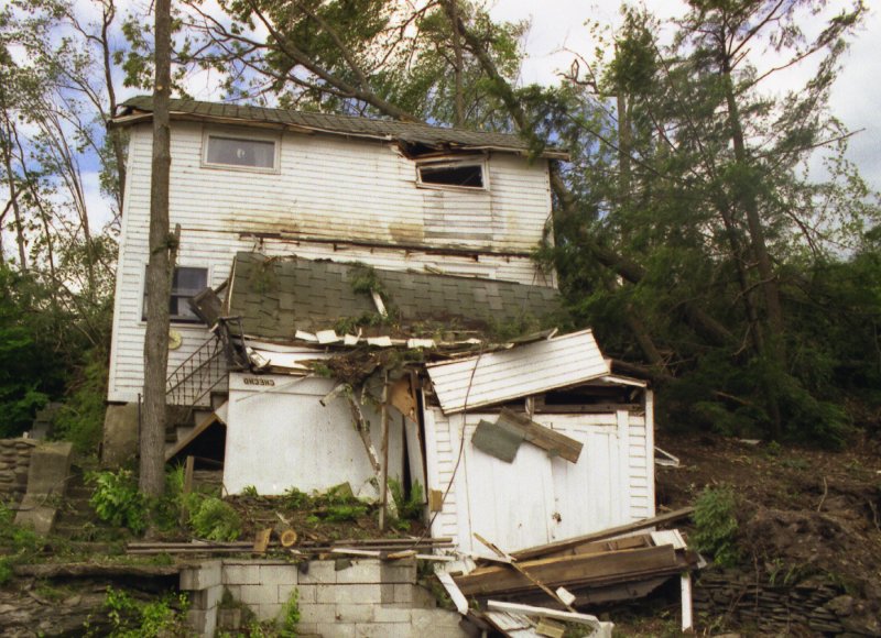 House and tree damage Lake Carey, PA area. |
 More house and tree damage Lake Carey, PA area. |
 Roof colapse Lake Carey, PA area. |
 House damage Lake Carey, PA area. |
 More house damage Lake Carey, PA area. |
 Damage to structures Lake Carey, PA area. |
 More house damage Lake Carey, PA area. |
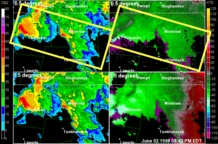
| The loop below is a zoomed in look at the severe storms that moved across parts of Bradford and Susquehanna counties. The yellow rectangles show the path of the storms. Top two are the radar beam at 0.5 degree elevation and the bottom two are 1.5 degrees. Images on the left are base reflectivity and images to the right are storm relative motion. Note the storm that moves from Towanda, PA to eastward. Then another storm moves just south of Towanda, PA and eastward at the end of the look. These are the severe storms. |
 |
Susquehanna County Summary
A severe thunderstorm moved across Bradford county during the evening of June 2, 1998 and moved into Susquehanna county shortly after 800 PM. The storm then intensified and produced a tornado that moved eastward across sparsely populated areas of Susquehanna county between Auburn and Lathrop townships (see photos below). The tornado was given an F1 rating based primarily on the tree damage observed along its path.
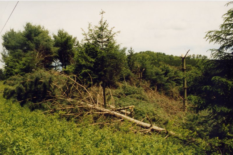 Trees down between Auburn and Lathrop townships. |
 Trees down between Auburn and Lathrop townships. |
Radar reflectivity loop from the NWS Binghamton, NY WSR88D radar.
This radar loop was from 05:00 PM EDT (2100 UTC) June 2, 1998 to 01:52 AM EDT (0552 UTC) June 3, 1998.
There are two loops, one with city labels and one without. There is no audio with this video.

