Please click on one of the tabs below to read a summary of the storms in each of these areas.
Broome/Delaware/Tioga Counties
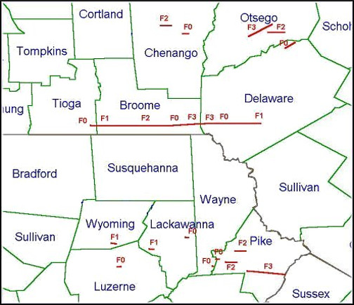
A severe thunderstorm moved from Steuben county of New York into Tioga county where it intensified enough to spawn tornadoes Sunday evening. A narrow 60 mile long path was carved from Apalachin in Tioga county through the town of Binghamton in Broome county and on to deposit in Delaware county.
Damage produced by a weak tornado across Apalachin was classified as an F0 on the Fujita scale.The small tornado produced winds between 40 and 72 MPH. Damage ranged from large tree limbs down to tree tops snapped off over the hilltops. The path was about 200 feet wide at this point. Damage in vestal was mostly F1 with winds between 73 and 112 MPH. Several homes from Rockwell Road through Horan Road experienced damage around 545 PM EDT.
As the storm moved into the Binghamton and Conklin (see below) area between approximately 600 PM and 610 PM EDT, the tornado intensified and reached a category F2 producing winds between 113 and 157 MPH. A television station on Ingraham Hill (see below) sustained major structural damage. A 1000 foot television tower was twisted and toppled to the ground. A large trash dumpster was also lifted off the ground tossed into two satellite dishes and then tossed about 100 yards over an embankment. A sport utility vehicle was rolled over several times as witnessed by a television crew member. Another automobile was also moved and a three quarter inch video tape was carried one and one half miles away from the television station. The damage path at this point was about 100 yards wide.
The tornado weakened and lifted for a short period and crossed over Winsor at about 615 PM EDT in Broome county. There were a few places where brief touch downs were noticed. In this area damage was consistent with a weak F0 tornado and consisted of tree tops snapped and/or twisted off. The path was about 100 feet wide.
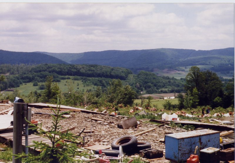
The storm reintensified as it moved into Sanford and produced F2 damage on Farnham Road at approximately 620 PM EDT. F1 damage was found as the tornado moved on to Ryan Road where a home had some siding and roofing torn off and a NYSEG electical sub station sustained significant damage (see below). A mobile home on Cheese Factory Road (see below) was also rolled over and destroyed during this time.
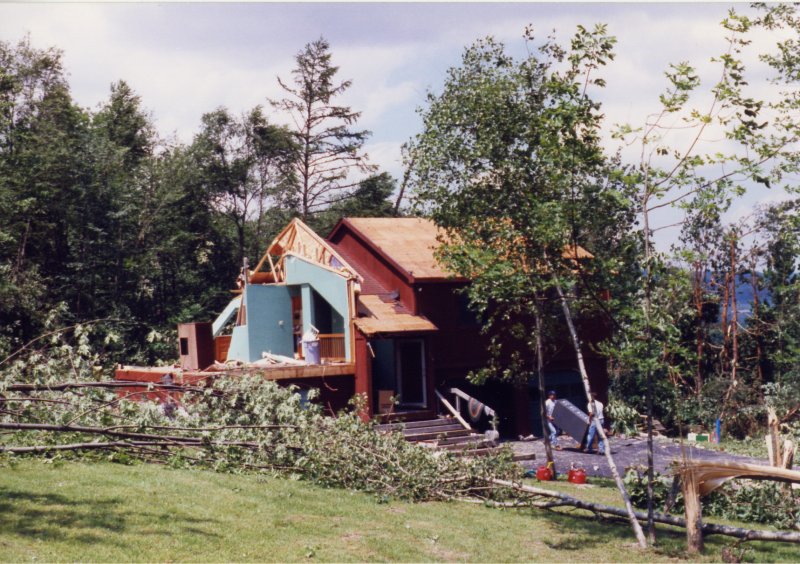
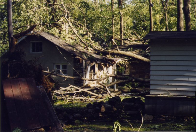
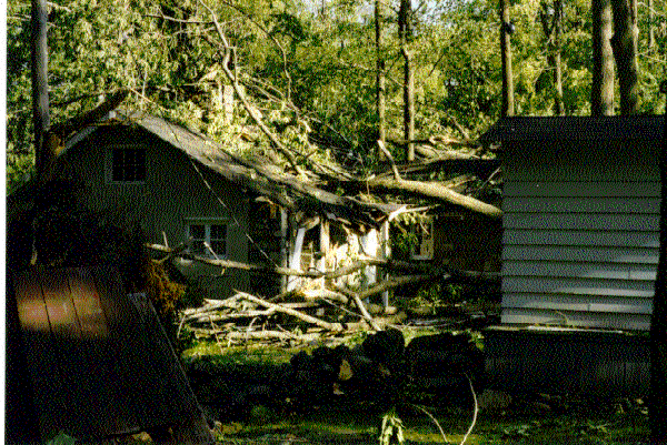
The tornado reached its maximum strength, F3 intensity producing winds between 158 and 206 MPH, over the town of Deposit at approximately 630 PM EDT. The path was consistent in direction and skipped along the hilltops with occasional touch downs into the valley floors. The greatest damage occurred on Nelson Frank Road (see below) where a house was completely destroyed. The only part of the structure that remained standing appeared to be a small interior closet. The occupants of the house described the noise as a freight train as the tornado approached. The path of the storm at this point was about 200 yards wide.
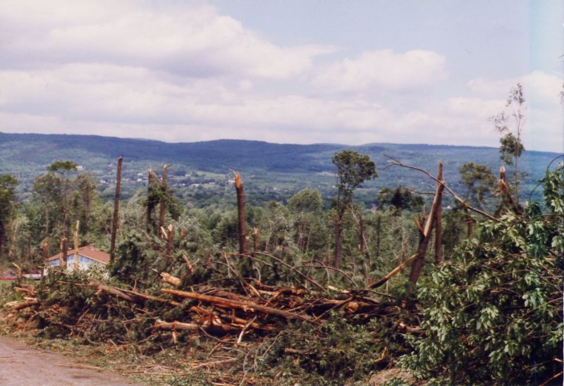
The storm began to weaken as it moved out of Deposit. F2 damage occurred at about 635 PM EDT on Route 8 (see below) where several homes experienced significant roof and structural damage. Additional F0 to F1 damage was observed as the tornado continued to move eastward through Tompkins (see below) and Colchester townships. A second tornado was reported to have moved through this same area shortly after the first one, again producing F2 damage to a home on Route 8.
|
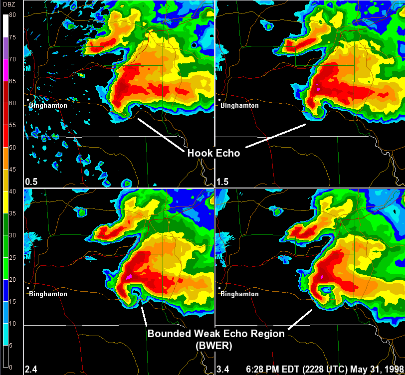
The image below shows Base Reflectivity through different elevations through the storm. Each panel is labeled with its corresponding elevation of the radar antenna, upper left hand panel is 0.5 degrees, etc. The image shows a tornadic storm over the eastern sections of Broome county. The tornado reached its maximum strength, F3 intensity producing winds between 158 and 206 MPH, over the town of Deposit at approximately 630 PM EDT. |
 |
Click for a large view.
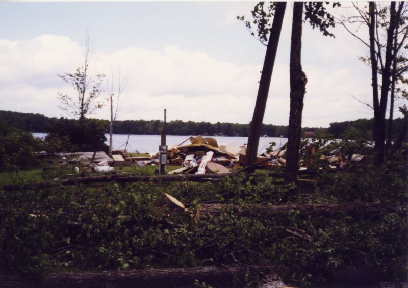
House Damage Wilcox Road Conkin, NY |
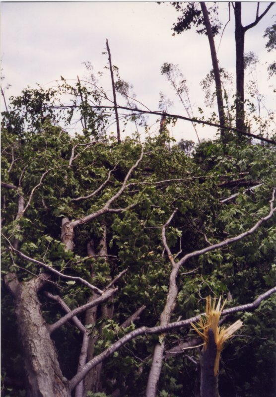
Trees Down Conklin, NY |
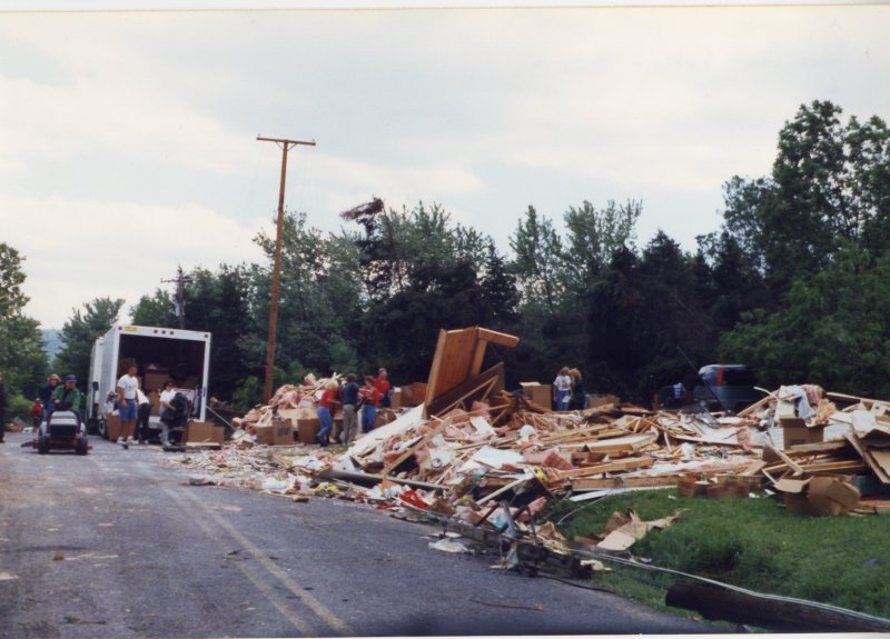
Mobile Home Damaged Hardie Street Conklin, NY |
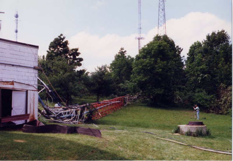
Tower Down Ingram Hill Binghamton, NY |
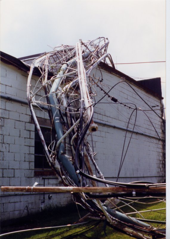 More Towers Down Ingram Hill Binghamton, NY |
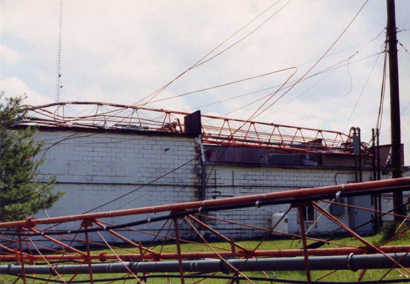 Towers Down Ingram Hill Binghamton, NY |
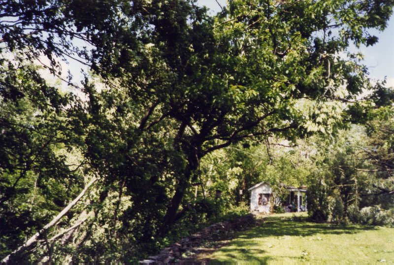
 Mobile Home Destoryed Cheese Factory Road Sanford, NY |
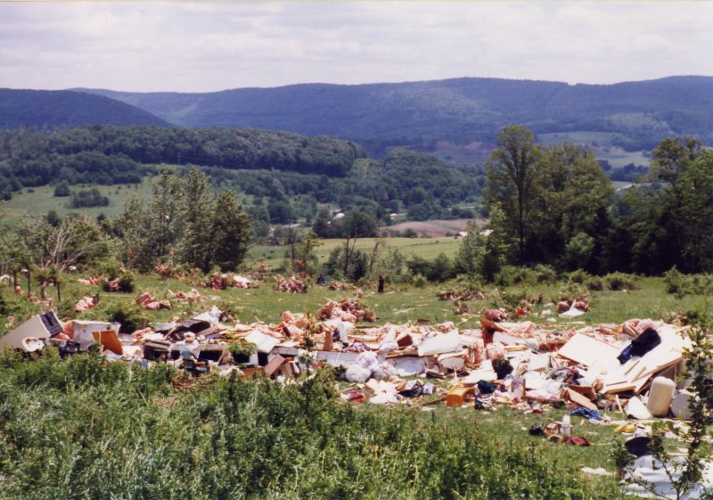 Another shot of the Mobile Home Destoryed Cheese Factory Road Sanford, NY |
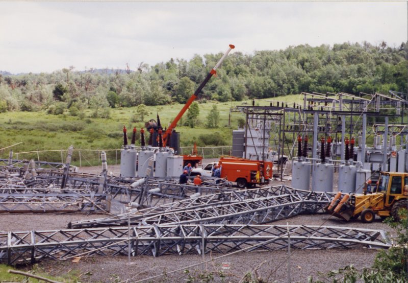 NYSEG Substation Ryan Road Sanford, NY |
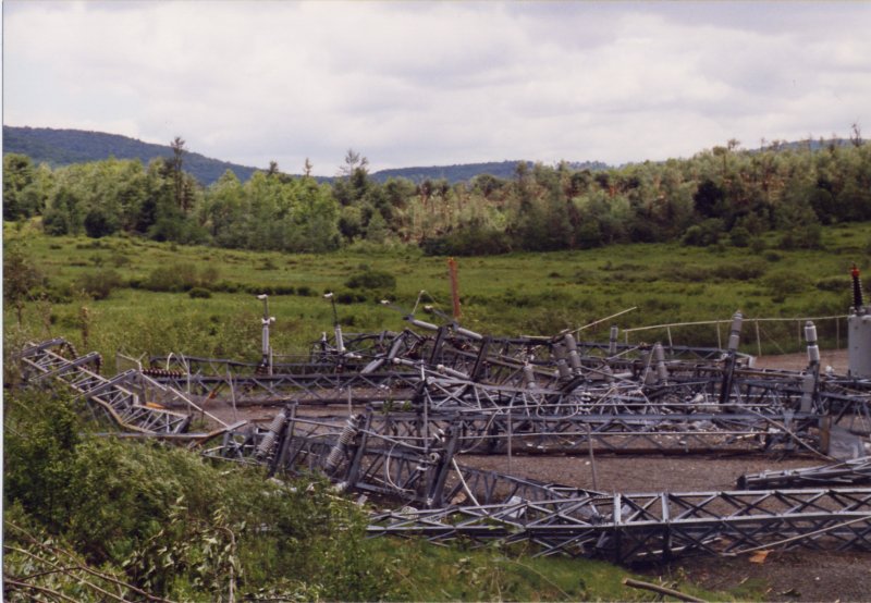 NYSEG Substation Ryan Road Sanford, NY |
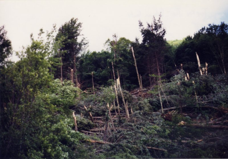 Trees Down Tompkins Township Delaware County |
 Promise Land State Park, PA |
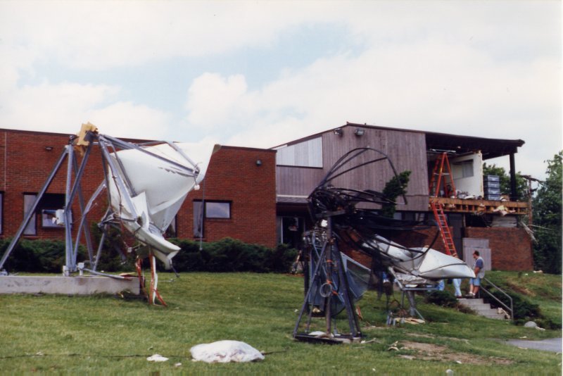 Ingram Hill Binghamton, NY |
|
|
Chenango County
During the afternoon of May 31, 1998, a tornado of F2 intensity touched down near Plymouth in Chenango county. The path width was 3/8 mile with a length of approximately one mile. Extensive damage was found near Plymouth Reservoir (shown below). The difference between the northwest side of the reservoir and the southeast side was phenomenal. No damage was evident on the northwest side but massive damage with near complete destruction of trees was present on the southeast side. Some lake side cottages received light to moderate wind damage but most of the damage to structures was due to falling trees and limbs. Boats and small wood and metal sheds were tossed about. The most significant damage occurred to a medium sized travel trailer which was located in the direct path of the storm and was completely destroyed.
The forest on the southeast side of the lake was nearly flattened. Only twisted and broken shards of trees were left standing. There were eyewitness reports of a funnel dropping down on the lake and literally sucking water into it. First appearing on the northeast side of the lake then "jumping" to the south side and intensifying. There was also reports of debris being sucked up into the air and rotating about. Witnesses also reported a sound like "the roar of a train" commonly associated with tornadoes.
The storm moved east and weakened to an F0 tornado as it touched down 1.5 miles east of Norwich on State Route 23. The path width was 1/4 mile with a length of 75 yards. Broken tree limbs and a few uprooted trees (shown below) were found on the windward side of a north-south ridge line. The damage area extended in at west to east direction and was parallel to or directly on State Route 23. One billboard was blown down and some metal roofing was blown off a very large barn. There was also some roof and siding damage to a small house about 1/8 of a mile to the southeast of the barn. Firemen in the City of Norwich observed a funnel cloud moving in the direction of the damage.
Click for a large view.
Trees Down Norwich, NY |
Mobile Home Destroyed Plymouth |
Trees Down Plymouth |
Otsego County
On Sunday, May 31, 1998 severe thunderstorms crossed Otsego county during the afternoon and early evening hours. Severe thunderstorm warnings were issued at 3:03 PM and a tornado warning was issued at 6:04 PM. On June 1, the National Weather Service did an aerial survey of the area which confirmed the touchdown of a tornado in the area just North of Oneonta airport near the Town of Laurens. Extensive tree damage and some damage to structures was visible along the damage path between Laurens and Milford. On June 2 and 3rd, the National Weather Service surveyed this area on the ground to further study the damage. This report is the result of these investigations. The information is supplemented by information received from Otsego County emergency management officials.
Damage from the first storm was reported between 3:30 and 4:00 PM and was spotty, with downed trees in the Oneonta and Cooperstown areas and a couple of barn silos toppled. This damage was most likely caused by straight line winds associated with the thunderstorm outflow boundary and microbursts.
Between 5:30 and 5:40 PM, a severe thunderstorm crossing Chenango county began to show signs of increasing low level rotation on the Doppler radar. Forecaster's upgraded the severe thunderstorm warning for Chenango county to a tornado warning at 5:40 PM. As the storm approached Otsego county, the strong low level rotation continued, so a tornado warning was issued for Otsego countyat 6:04 PM.
Otsego tornado #1 (F3)
Around 6:10 PM a tornado touched down near Silver Lake (Route 13). Three houses along Route 13 were heavily damaged. One modular home was shifted partially off its foundation.
F2 damage occurred in this area. As the storm moved east the tornado appears to have lifted up and touched down numerous times. In the village of Morris several trees were toppled and 3 mobile homes were damaged on the hillside just east of town. North of Morris there was tree damage on Braun Hill in the town of New Lisbon.
As the storm approached Lake Brook and Gilbert Lake Rd and Balantic Hill Rd. about 1.25 miles northwest of Laurens the tornado touched down again. Here (reference point 1) one foot diameter pines were snapped at 20 feet. The damage extended for a distance of about 300 feet to the east. A half mile north of (1) a tree fell onto a house. A quarter mile northeast of (1) near the top of the ridge two eyewitnesses were interviewed. The first witness (Joan Varian) said she was watching a Syracuse TV station when she heard the tornado warning for Chenango county around 5 PM. Then around 6:11 PM she says she heard a loud continuous roar which sounded like a jet airplane. She had isolated trees down over a 300 foot wide path, but there were no shingles off her roof (F0 damage). Apparantly, the tornado passed just south of her residence.
Just up the street another resident, Theresa Oellrich, witnessed the event. Theresa said the wind hit very suddenly and for around 60 seconds the windows rattled so hard she thought they would shatter. The wind shook the house so bad the locked sliding glass door on rear of the house opened on its own. A heavy charcoal grill was picked up and dropped 20 feet to the north. The top 6 feet of the masonry block chimney was blown down to the east. Vinyl soffit and siding on the west side of the house was damaged. Several bird houses on 4 ft by 4 ft wooden posts were pulled out of the ground and scattered. A 300 yard wide area behind the house and to the north had many trees snapped off 20 feet above the ground. For the next 300 yards along the road to the south many large trees were uprooted. The intensity of this tornado was rated as F1 with a path width of 600 yards.
One half mile east of (1) the path crossed another road. Here, a house lost a few shingles and most of the many large trees on the lot were uprooted. Cherry trees were snapped. The driveway was covered with twisted and mangled trees in multiple directions. The residents said they heard a "swish" sound - like a train. Then everything went grey and they went to the cellar. They did say they heard the warning on their scanner. Across the street, a large maple tree fell on an old house being used as a shed. The resident of a new house on the same lot said that "it was very sudden, all you could see was water and wind, all you could hear was creaking and cracking of the house." His trees were all twisted with one tree thrown up into another one (to the north). A pop up camper was rolled into the woods and its roof disappeared. At the next house trees were blown down to the south. The intensity of this tornado was rated as F1 with a path width of 600 yds.
The tornado caused little damage on the east facing slope down into the Pool Brook Valley. Then as the storm crossed the rising terrain of the west facing slope, the tornado touched down again. This time four separated damage tracks (swaths of trees) were found up the hillside over a north-south distance of one half mile. This damage was 1 to 1.5 miles due north of Laurens. Each swath of trees was 100 to 150 yds wide with 100 to 300 yds between them. They were oriented pretty close to east-west. It is believed that this was one multi-vortex tornado with 4 separate funnels on the ground at this point as the storm was intensifying. The northernmost damage was F1 intensity, cutting a 150 yd by 500 yd swath up the hillside. Most trees were snapped off or uprooted. A lucky trailer at the base of the valley received no apparent damage. To the south of this swath of trees, there was about 200 yds of F0 damage before another swath of trees received F1 damage up the hillside. This track was about 100 yds by 600 yds. The damage continued into the Otego Valley across Route 11. Here huge (4 foot diameter) maples were snapped at 15 feet off the ground (F1).
Another 200 yds down the road a third swath of downed trees crossed the road and went up the hillside. Here the ridge line drops off to the south as Pool Brook Valley merges with the Otego Creek Valley. This may have enhanced the local vorticity as the winds traveled around the south end of this ridge and may have assisted in the spin-up of these additional 2 vortices. This tornado cut a 200 yd wide swath which was estimated to be at least 1000 yds long. In the area first viewed, all the trees were snapped off or uprooted. Many of these were maples with 8-14 inch diameter trunks. The severe intensity and of the tree damage along a few parts of this track is consistent with F2 damage. Damage continued into the Otego Valley across Route 11. Here the tin roof of a shed was hanging in the overhead wires, isolated trees were snapped off, and the skirt was blown out from underneath a trailer (F0 Damage).
One hundred yds further south, a fourth area of tree damage was found. In this Area of large pines with some large maple, roughly 50% of the pines Were snapped off in chaotic directions and some of the maples Uprooted. Damage was light indicating F0 damage along this 100 yd Wide by 500 yd long path. Damage continued into the otego valley Across route 11. Here the roof of a barn was slight damaged and tree Tops snapped (F0).
On the east side of Otego Creek, along Route 205, damage extended from one mile north of Laurens all the way to Mt. Vision, with the worst damage right around Dutch Hill Road. Just south of a Dutch Hill farm, three swaths are still evident, again indicating multiple vortices. At Dutch Hill farm, the dairy barn, milking shed, and silo suffered major damage. The barn roof was torn off with large 8 by 8 by 18 foot barn timbers thrown up to 200 feet. A 40 lb piece of steel railing from over the barn door was thrown 200 feet. Some 2 by 6 by 8 foot floor boards thrown 300 feet. Roof joists 3 by 6 by 10 feet blown 300 feet. Heavy farm implements, a hay bailer and corn chopper, were blown about 50 feet. The house, which wasn't far from the barn, received only minor damage. Damage to the farm indicates a F1/F2 tornado
Mr. Milan Djurdjevich, the farm owner, was with his father, mother, and friend, milking cows in the barn as the storm approached. There was no unusual noise as the storm approached. All of sudden Milan noticed something very strange in the cows behavior. Cows love their Silage. Yet, all the cows had there heads up looking toward the southwest side of the barn. They had all stopped eating. Milan instinctively yelled at everyone to head for the north side of the barn as he went to the milking shed on the southwest side to shut the door. As he tried to shut the door he was blown back against the barn and pinned against the wall by the force of the wind. At this point the wall of the milking shed was peeled off and blew away. Milan finally made it to the door as the barn itself lost its top story to the wind and floor timbers overhead were ripped into the air. No one was injured. During the storm a calf was born, cleaned by the wind and rain. She's been named "tornado". Based on a stopped clock, the time the tornado arrived was estimated to around 6:12 PM.
Further to the north in Mt. Vision, lots of large trees fell, some on homes, throughout the town. These were mostly uprooted maples and large limbs. Damage here is F0 and consistent with damage due to strong straight line winds in very close proximity to the tornadoes.
The tornado intensified as it rode up the hillside (Dutch Hill Road, Lane Hill Road) into the Millford State Forest. Here, the tree damage was incredible, cutting a half mile wide x 3 mile long path of destruction through the middle of this once pristine area. The worst damage seemed to follow up a valley to the east- northeast from Dutch Hill Road. Essentially, a large part of the woodland in the Millford state forest has been destroyed. Where there had been 500 acres of dense forest, the woods are clear cut with all trees uprooted and snapped. Only the main trunks of a few trees were left standing. Parts of Lane Hill Road were totally inaccessible due to the piles of trees dumped on top of one another (F3 damage).
As the tornado got to the top of the ridge it lifted a bit, allowing it to pass north of and skip over a couple of one story houses on the ridge top. These homes had some trees down and snapped off. One tree fell on a house. Some shingles and siding were stripped off a house and the top of the chimney was blown off. The owner said the wind hit suddenly. All of sudden they couldn't see 50 feet across the yard and they ducked into the center of the house as it shook (F1 damage). To the north of the homes, F2 damage continued for another half mile east. Another house with a tree on it was just southeast of Lane Hill.
As the storm moved east across the saddle along Lane Hill Road which runs between Lane Hill and Dutch Hill, patchy areas of uprooted and snapped trees could be found (F1 damage). The tornado tracked just south of Lane Hill Road. The tornado track took it one half mile south of Edson Corners and one mile south of Milford. On Tansey Hill Road, lots of trees were sheared off around two houses, but the homes themselves appeared to have little damage (F1 damage).
As the tornado came down into the Susquehanna Valley, a dairy farm on Route 28 took a direct hit from the storm. As it came down the east facing slope, it snapped off most of the trees on the hillside in a swath 100 yds across. First it slammed into a pole barn and area of veal huts. The fiberglass huts were blown 200 yards north. Several calves were killed. The pole barn was completely gone. Further down the hill, the main barn lost some of its roof and the top of its silo which fell nearby. A piece of the barn roof was blown north, through a window and into the living room of the house. Across Route 28, another barn was destroyed and a trailer was overturned several times. A small refrigerator inside the trailer was reportedly blown 100 yds east into a pond (F1 damage).
As the tornado headed up the west face of Crumhorn Mountain, 2 miles southeast of Milford, it took out another major swath of trees up the entire face. From the distance, this appeared to be F1 damage. 150 yds by one half mile swath of trees were damaged.
According to Lyle Jones, emergency manager, spotty damage continues further east to the county line.
Otsego tornado #2 (F2)
Approximately 2.5 miles south of the first tornado track, another tornado touched down from this same supercell storm. This tornado may have first touched down briefly around Morris where several mobile homes were damaged. The first confirmed touchdown was 1 mile north of Portlandville along Route 44. A 50 yd wide swath of trees sustained considerable damage (F1). As the storm crossed the ridge and into the Susquehanna Valley, it caused little damage. Then, it touched down again on the west facing slope of Crumhorn Mountain, producing a 100 yd by one half mile swath of downed trees. About 50 % of the lower elevation trees were down (F1) with 100 % of the trees gone on the ridge top (F2). This storm then tracked east to Maryland where there were scattered downed trees and some minor damage to structures (F0).
County damages
Lyle Jones, Otsego County emergency manager, reports that 250 structures (agricultural, residential, business) were damaged by the storms countywide. Damage to forests and trees was extensive.
Please click on one of the tabs below to read a summary of the storms in each of these areas.
Wayne and Pike counties
Damage survey for May 31st, 1998 across Wayne and Pike counties in Northeast Pennsylvania
The ground damage survey began in Pike county at Promised Land State Park. Heading southward from I84 off exit 7, along SR 390, extremely heavy damage was evident inside the park near the town of Promised Land on both sides of SR 390. There was a sharp gradient in the damage, going from a heavily forested area into an area that had been completely stripped of all trees within 50 feet. On the west side of the road was an area of cabins and trailers that sloped downhill to the west. Past this area, the trees were broken off higher up as the tornado was lowering and moving in from the west and encountering the higher terrain. Many of these trailers and cabins had some siding peeled away, but had more extensive damage from falling trees. East of SR 390, the land was level and the trees were uprooted or twisted off within 6 feet of the ground. About one half mile of land is between SR 390 and the lake shore and every tree was either uprooted or sheared off in a 3/10 mile wide path.
Witnesses were hard to come by in this area. The local fire station was right on the edge of the damage path but none of the volunteers were there at the time. The fire chief claimed to get the first damage report of his fire radio at 730 pm. Most of the trailers and cabins in this area are seasonal and/or weekend homes and were not occupied on Sunday night.
The survey continued around the north side of the lake to access a peninsula in the middle of the lake due east of the town of Promised Land. The damage on this peninsula was the most extensive, with complete destruction of a mature stand of oaks, some with trunk diameters exceeding 2 feet. Most of the trees were not uprooted, but were twisted off at about the 5 foot level. Most of the damage to the cottages was done by these Damage to home. heavy trees falling on the roofs of the cottages. There was some minor wind damage. There was no damage in the immediate area further east including the east shore of the lake.
The damage in this area near Promised Land was estimated to be of F2 intensity based on the size of the trees damaged. The path width was approximately 3/10 of a mile wide and 2 miles in length.
Due to the hilly terrain present across Wayne and Pike counties, this was the only ground survey conducted in the area following the tornado outbreak on May 31, 1998. In the days and weeks that followed, numerous other reports of damage and photographs were received by NWS Binghamton from residents, visitors, and the media. By using the additional information and comparing it to radar images from corresponding times, it was possible to confirm several additional tornado damage paths across Wayne and Pike counties.
A damage path near Salem and Dryer townships in southern Wayne county was given an intensity of F0. Another path went through the Blue Heron Lake area and was rated as an F3 while yet another path went through the Blooming Grove area and was given a rating of F2. These tornadoes were associated with a pair of supercell thunderstorms which moved through southern Wayne and Pike counties between roughly 800 PM and 845 PM on May 31, 1998. Damage in the Lake Wallenpaupack area during this time was determined to be caused by straight line winds with only isolated tree and limb damage evident.
Luzerne County
A tornado of F0 intensity briefly touched down in Jackson Township during the evening of May 31st, 1998. The path width was 40 yards and length was 50 yards. The tornado touched down in sparse forest land. Several trees were uprooted but homes in the region had no visible damage.
Lackawanna County
A tornado of F1 intensity briefly touched down in Old Forge during the evening of Sunday, May 31st, 1998. The tornado skipped along its 30 yard wide path for about a half mile. Several trees were topped and a large tree was uprooted two blocks west of the fire station. The fire house sustained minor roof damage and had some bricks damaged. A cinder block dugout at a little league baseball field two blocks east of the fire station was destroyed. The circulation in the storm weakened as it moved east. However, another tornado of F0 intensity was spawned and briefly touched down in forest land along Route 348 in Jefferson Township. The path width was approximately 80 yards with a length of 100 yards. Damage was spotty and isolated with a few trees uprooted. One tree was completely defoliated and had its bark removed.Damage survey for May 31st, 1998 across Wyoming county in Northeast Pennsylvania
Initially ground damage survey began along CR 2020 which appeared to be the eastern end of the damage track. This area was a westward facing slope of a hill where twisting damage to the trees and the chaotic debris field provided evidence of a tornado. Structures near the trees appeared to be unaffected but overall damage was consistent with an F1 tornado.
The survey continued traveling southwestward along CR 2020 back to SR 309, then up CR 2018, which is also known as Lake Alderson Rd. Initial damage was near the top of the hill at the Richard Clarke residence. Mr Clarke had no damage to his home but had several large maple, oak and pine trees uprooted or snapped off. He did have significant damage to a chain link fence on the western side of his property.
Heading south off CR 2020, considerable tree damage was noted on a private road. Again the damage was chaotic with trees lying in different directions, some being uprooted and some being twisted off. Within 50 yards of an extensive area of tree damage was a light duty, homemade greenhouse made of plastic film and 1x1 and wooden supports. It was undamaged. One of the homes did suffer roof damage when a large maple fell on it.
An ariel survey of this area revealed that a barn had lost it's roof just a few hundred feet up the hill from CR 2020 and that seemed to be the beginning of the damage. This F1 tornado had a non-continuous track one half mile long and 50 yards wide.
Radar reflectivity loop from the NWS Binghamton, NY WSR88D radar.
This radar loop was from 12:04 PM EDT (1604 UTC) May 31, 1998 to 01:58 AM EDT (0558 UTC) June 1, 1998.
There are two loops, one with city labels and one without. There are some data gaps around 2200 UTC.

