On the evening of January 6 into the 7, 2014 an arctic airmass moved over our area and would eventually produce dangerously cold wind chill values as low as -30° F or lower, record cold, and heavy lake effect snow over western and northern New York. Many schools would either delay or close due to the cold the following day, with parts of the New York state thruway and interstate 81 closed due to high winds, heavy snow, and very low wind chills.
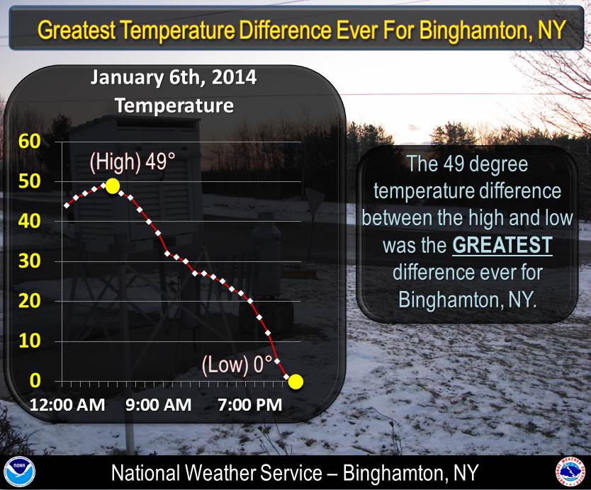
One climate statistic that stood out last week was the diurnal temperature range on Monday January 6th 2014 at all three climate sites. The diurnal temperature range is just the difference between the maximum and minimum temperature for the day. For example if the maximum for the day was 60° F and the minimum was 30° F, the diurnal range would be 30.
For Binghamton, NY, with a high of 49° F and a low of 0° F on January 6th, the 49° diurnal temperature range was the largest on record. The previous record was 47° change set on January 9th, 1978.
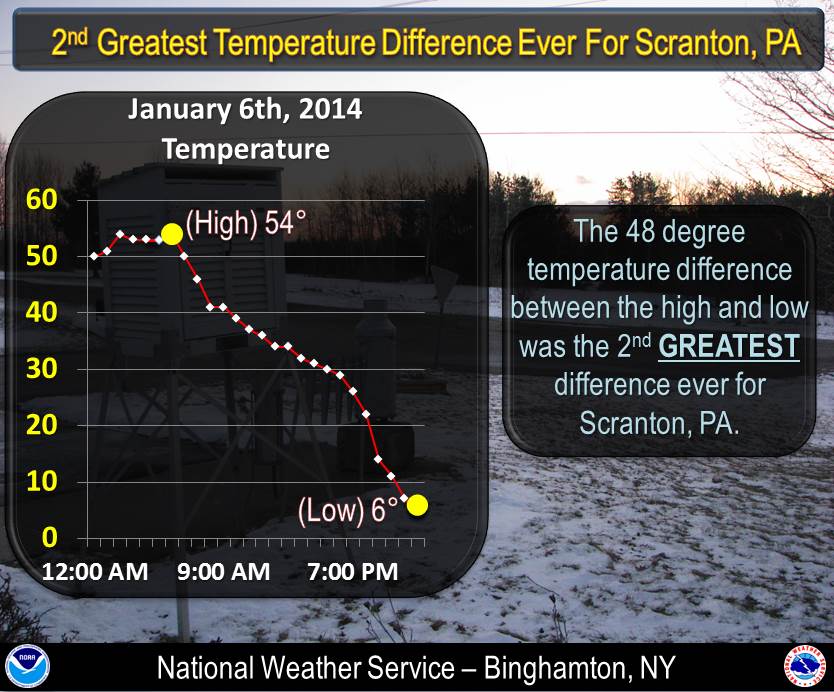
For Avoca, PA (Scranton), with a high of 54° F and a low of 6° F on January 6th, the 48° diurnal temperature range was the second largest on record. The record is a 53° range set on march 28th, 1921 when the high was 76° F and the low was 23° F.
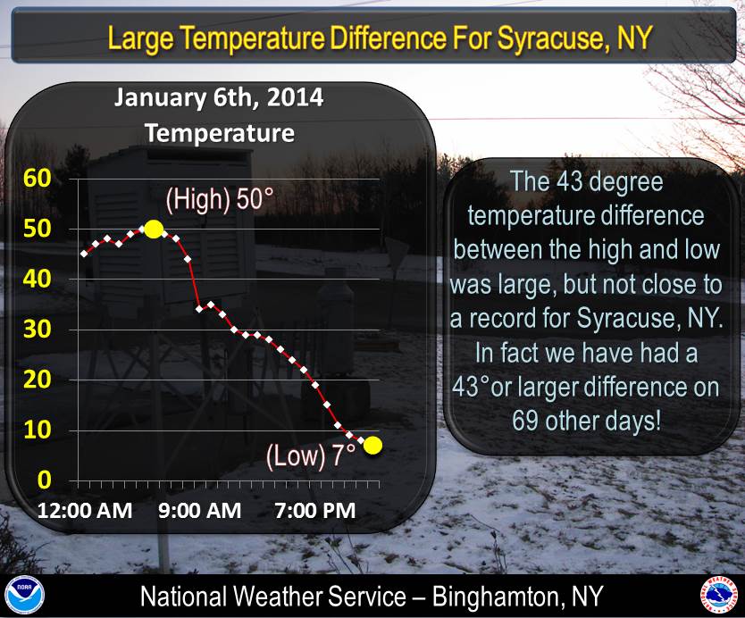
For Syracuse, NY, with a high of 50° F and a low of 7° F on January 6th, the 43° F diurnal temperature range wasn't even close to a record! In Syracuse we have had a 43° or greater difference 69 other times! The record for Syracuse is a 51° range set on April 28th, 2009 when the high was 85° F and the low was 42° F.
Record low temperatures were also recorded:
-
At Binghamton, NY a record low temperature of -8° F was recorded on January 7, 2014 breaking the old record of -1° F last set in 1996 and 1968. In addition, on January 7, 2014 the high temperature only reached 0° F. This breaks the old record for coldest high temperature for January 7 of 10° F in 1996. This high temperature was also the 3rd coldest in January. The coldest was -5° Fon January 19th in 1994. The average temperature of -4° F was the coldest for January 7. The old record was plus 4.5° F in 1996.
-
At Scranton Wilkes-Barre Airport, a record low temperature of -4° F was set on January 7, 2014. This broke the old record of 3° F set in 1998. In addition, the high temperature of 6° F was also the coldest for January 7, 2014. The old record of 14° F was set in 1942. This was the 8th coldest high temperature in January. The coldest high temperature in January was -2° F on January 9th, 1994.
-
At Syracuse, NY, the high temperature on January 7, 2014 was 8° F. This tied the coldest high temperature for January 7th. The old record was set in 1996.
Related information:
Lowest Tempertures and Wind Chills for Selected Locations (preliminary observations):
|
Minimum Temperatures |
|
Penobscot, PA |
-13 |
|
Binghamton, NY Airport |
-8 |
|
Elmira, NY |
-7 |
|
Monticello, NY Airport |
-6 |
|
Elmira, NY Airport |
-5 |
|
Ithaca, NY Aiport |
-4 |
|
Scranton, PA Airport |
-4 |
|
Penn Yan, NY Aiport |
-3 |
|
Rome, NY Airport |
-1 |
|
Syracuse, NY Airport |
0 |
|
|
|
Lowest Wind Chills |
|
Penobscot, PA |
-38 |
|
Keuka Park, NY |
-35 |
|
Binghamton, NY Airport |
-31 |
|
Penn Yan, NY Airport |
-31 |
|
Elmira, NY Airport |
-30 |
|
Monticello, NY Airport |
-26 |
|
Scranton, NY Airport |
-26 |
|
Rome, NY Airport |
-25 |
|
Ithaca, NY Airport |
-24 |
|
Syracuse, NY Airport |
-23 |
|
Lowest Tempertures and Wind Chills for more Locations (preliminary observations):
|
City/Town |
Minimum Temperature |
|
1 WNW GLEN SUMMIT |
-13 |
|
1 WSW NORTH HORNELL |
-13 |
|
1 NE PENOBSCOT |
-13 |
|
1 NW PRATTSBURG |
-12 |
|
3 SW VESTAL CENTER |
-12 |
|
5 SSW SPRINGBROOK CORNER |
-11 |
|
3 NW OVERTON |
-11 |
|
2 SE ORWELL |
-11 |
|
1 E LEHMAN |
-11 |
|
2 W NORTH HORNELL |
-10 |
|
2 SSE ERIN |
-10 |
|
BATH |
-10 |
|
DUNDEE |
-10 |
|
1 NW KOONSVILLE |
-10 |
|
CORNING |
-10 |
|
1 SSW FOREST CITY |
-10 |
|
DIMOCK |
-10 |
|
CANTON |
-9 |
|
ARKPORT |
-9 |
|
BATH |
-9 |
|
2 E PENN LAKE PARK |
-9 |
|
PLEASANT MOUNT 1 W |
-9 |
|
2 NE RIDGEBURY |
-9 |
|
2 SSW ENFIELD |
-9 |
|
1 NNW FERN BROOK |
-9 |
|
5 ENE BEAR CREEK |
-9 |
|
2 SSW GLENBURN |
-9 |
|
6 S SPRINGBROOK CORNER |
-9 |
|
2 SSW VESTAL |
-9 |
|
ASHMORE |
-9 |
|
MECKLENBURG 4 SW |
-8 |
|
HAWLEY 1 E |
-8 |
|
2 ESE ERWINS |
-8 |
|
1 W PLEASANT MOUNT |
-8 |
|
NEW MILFORD |
-8 |
|
BINGHAMTON (GREATER AP) |
-8 |
|
1 SSW SEELYVILLE |
-8 |
|
1 S UNIONDALE |
-7 |
|
1 W ARLINGTON |
-7 |
|
PLAINS |
-7 |
|
2 N BRACKNEY |
-7 |
|
3 SE ENDWELL |
-7 |
|
1 SE KANONA |
-7 |
|
ELMIRA |
-7 |
|
1 E HUDSON |
-7 |
|
1 S WILKES-BARRE |
-7 |
|
1 S HUDSON |
-7 |
|
1 N JOHNSON CITY |
-7 |
|
4 WNW CONKLIN |
-7 |
|
1 ESE GOULDSBORO |
-7 |
|
2 NNE FERN BROOK |
-7 |
|
3 E OXFORD |
-7 |
|
1 SW AUBURN |
-6 |
|
OWEGO 3 WSW |
-6 |
|
WHITNEY POINT |
-6 |
|
WEST CANDOR |
-6 |
|
1 WNW THROOP |
-6 |
|
WILKES-BARRE |
-6 |
|
2 ENE NORTH TOWANDA |
-6 |
|
2 SE SMITHVILLE FLATS |
-6 |
|
SULLIVAN COUNTY INTERNATIONAL AIRPORT |
-6 |
|
CHEMUNG |
-6 |
|
ONONDAGA |
-6 |
|
1 N MEHOOPANY |
-6 |
|
DORRANCE |
-6 |
|
4 WNW SHERMAN |
-6 |
|
CANDOR |
-6 |
|
1 NNE AUBURN CENTER |
-5 |
|
4 NNE MIDDLEFIELD |
-5 |
|
3 ENE ITHACA |
-5 |
|
BOONVILLE 4 SSW |
-5 |
|
2 ESE KEUKA PARK |
-5 |
|
1 ENE MANLIUS |
-5 |
|
PROMPTON DAM |
-5 |
|
UNADILLA 2 N |
-5 |
|
3 WSW COLUMBUS |
-5 |
|
LOCH SHELDRAKE |
-5 |
|
WINTERDALE |
-5 |
|
ELMIRA/CORNING REGIONAL AIRPORT |
-5 |
|
1 WNW HOWARD |
-5 |
|
MARATHON |
-5 |
|
SKANEATELES |
-5 |
|
2 NW MADISON |
-5 |
|
1 ESE STAMFORD |
-5 |
|
3 SSE YOUNGS |
-5 |
|
GLEN SPEY |
-5 |
|
2 SW GREENE |
-5 |
|
WALTON 2 |
-4 |
|
1 E VOSBURG |
-4 |
|
1 SSE KIRKWOOD |
-4 |
|
ROMULUS |
-4 |
|
TOWANDA 1 S |
-4 |
|
1 E ITHACA TOMPKINS ARPT |
-4 |
|
1 NE FREEVILLE |
-4 |
|
1 NE ONEONTA |
-4 |
|
WILKES-BARRE/SCRANTON INTL |
-4 |
|
2 E FERGUSONVILLE |
-4 |
|
2 SW BRISCOE |
-4 |
|
2 SE CLARKS GREEN |
-4 |
|
1 SE BINGHAMTON |
-4 |
|
CARBONDALE |
-4 |
|
PENN YAN |
-4 |
|
1 SW WEST CORNERS |
-4 |
|
1 W NORTH NORWICH |
-4 |
|
3 N SULLIVAN |
-3 |
|
1 ESE GLEN LYON |
-3 |
|
1 N TULLY |
-3 |
|
LOOMIS |
-3 |
|
1 E TULLY |
-3 |
|
1 S JOHNSON CITY |
-3 |
|
LOCH LOMOND |
-3 |
|
1 N LAKELAND |
-3 |
|
PENN YAN AIRPORT |
-3 |
|
3 WNW MERIDALE |
-3 |
|
3 S NEW BERLIN |
-3 |
|
2 N GLENWOOD |
-3 |
|
1 N SHERBURNE |
-2 |
|
AUBURN |
-2 |
|
SIDNEY |
-2 |
|
2 N NORWICH |
-2 |
|
AURORA RESEARCH FARM |
-2 |
|
2 E CHERRY VALLEY |
-2 |
|
NANTICOKE |
-2 |
|
MORRIS |
-2 |
|
2 NW ORAN |
-2 |
|
FAIRMOUNT |
-2 |
|
1 ENE NEDROW |
-2 |
|
2 SSW JOHNSON CITY |
-2 |
|
1 NNE BARRYVILLE |
-2 |
|
1 NNW SHERBURNE |
-2 |
|
1 WNW NORWICH |
-2 |
|
3 NNW LA FAYETTE |
-2 |
|
3 NE CLEVELAND |
-2 |
|
NORWICH |
-1 |
|
MILFORD |
-1 |
|
HYDE PARK |
-1 |
|
DELTA DAM (THIS IS SITE LOCATION) |
-1 |
|
1 E LEONARDSVILLE |
-1 |
|
1 SE LAKEPORT |
-1 |
|
1 ESE DELTA LAKE |
-1 |
|
ITHACA |
-1 |
|
4 NW WESTMORELAND |
-1 |
|
GRIFFISS AIRFIELD AP |
-1 |
|
1 N SENECA FALLS |
-1 |
|
4 WSW CLINTON |
-1 |
|
1 ENE CHADWICKS |
-1 |
|
2 WSW CICERO |
-1 |
|
2 E CHADWICKS |
-1 |
|
JERMYN |
-1 |
|
SOLVAY |
-1 |
|
1 E LAKEVILLE |
-1 |
|
4 W OTISCO |
0 |
|
1 NW MINOA |
0 |
|
HAMILTON |
0 |
|
BREWERTON LOCK 23 |
0 |
|
SHERBURNE |
0 |
|
1 WNW SYRACUSE |
0 |
|
1 ESE LAURENS |
0 |
|
1 WSW CICERO |
0 |
|
COOPERSTOWN |
0 |
|
SYRACUSE HANCOCK INTL ARPT |
0 |
|
CORTLAND COUNTY CHASE FIELD |
0 |
|
1 W NORTH SYRACUSE |
0 |
|
1 NNE EAST SYRACUSE |
0 |
|
1 ESE CLAY |
0 |
|
NEW HARTFORD |
0 |
|
|
|
City/Town |
Lowest Windchill |
|
1 NE PENOBSCOT |
-38 |
|
2 ESE KEUKA PARK |
-35 |
|
1 SSW FOREST CITY |
-35 |
|
1 NW PRATTSBURG |
-33 |
|
ARKPORT |
-33 |
|
DUNDEE |
-33 |
|
1 WNW GLEN SUMMIT |
-33 |
|
1 N JOHNSON CITY |
-33 |
|
1 E LEHMAN |
-33 |
|
1 SE KANONA |
-32 |
|
1 WSW NORTH HORNELL |
-32 |
|
4 NNE MIDDLEFIELD |
-31 |
|
1 E HUDSON |
-31 |
|
2 SSW GLENBURN |
-31 |
|
1 NW KOONSVILLE |
-31 |
|
BINGHAMTON (GREATER AP) |
-31 |
|
1 SSW SEELYVILLE |
-31 |
|
PENN YAN AIRPORT |
-31 |
|
1 SW AUBURN |
-30 |
|
3 SW VESTAL CENTER |
-30 |
|
BATH |
-30 |
|
2 NE RIDGEBURY |
-30 |
|
ELMIRA/CORNING REGIONAL AIRPORT |
-30 |
|
2 SE ORWELL |
-30 |
|
DIMOCK |
-30 |
|
2 SSE ERIN |
-29 |
|
1 ENE MANLIUS |
-29 |
|
1 NNW FERN BROOK |
-29 |
|
1 S HUDSON |
-29 |
|
1 WNW HOWARD |
-29 |
|
SKANEATELES |
-29 |
|
2 SSW VESTAL |
-29 |
|
PLAINS |
-28 |
|
3 NW OVERTON |
-28 |
|
1 W ARLINGTON |
-27 |
|
1 WNW THROOP |
-27 |
|
SULLIVAN COUNTY INTERNATIONAL AIRPORT |
-27 |
|
1 N LAKELAND |
-27 |
|
ONONDAGA |
-27 |
|
4 WNW CONKLIN |
-27 |
|
1 S WILKES-BARRE |
-26 |
|
NEW MILFORD |
-26 |
|
2 E CHERRY VALLEY |
-26 |
|
WILKES-BARRE/SCRANTON INTL |
-26 |
|
2 NW MADISON |
-26 |
|
2 NNE FERN BROOK |
-26 |
|
3 E OXFORD |
-26 |
|
3 N SULLIVAN |
-25 |
|
2 N BRACKNEY |
-25 |
|
1 E TULLY |
-25 |
|
2 ENE NORTH TOWANDA |
-25 |
|
GRIFFISS AIRFIELD AP |
-25 |
|
6 S SPRINGBROOK CORNER |
-25 |
|
1 NNW SHERBURNE |
-25 |
|
1 SSE KIRKWOOD |
-24 |
|
2 ESE ERWINS |
-24 |
|
1 E ITHACA TOMPKINS ARPT |
-24 |
|
1 W PLEASANT MOUNT |
-24 |
|
2 SE SMITHVILLE FLATS |
-24 |
|
FAIRMOUNT |
-24 |
|
ASHMORE |
-24 |
|
5 SSW SPRINGBROOK CORNER |
-23 |
|
1 E VOSBURG |
-23 |
|
SIDNEY |
-23 |
|
2 N NORWICH |
-23 |
|
1 WNW SYRACUSE |
-23 |
|
1 ESE LAURENS |
-23 |
|
SYRACUSE HANCOCK INTL ARPT |
-23 |
|
LOCH SHELDRAKE |
-23 |
|
MARATHON |
-23 |
|
1 N MEHOOPANY |
-23 |
|
2 NW ORAN |
-23 |
|
CANDOR |
-23 |
|
CARBONDALE |
-23 |
|
SOLVAY |
-23 |
|
ROMULUS |
-22 |
|
1 SE LAKEPORT |
-22 |
|
3 WSW COLUMBUS |
-22 |
|
1 ENE NEDROW |
-22 |
|
1 ESE GOULDSBORO |
-22 |
|
4 WSW CLINTON |
-22 |
|
4 WNW SHERMAN |
-22 |
|
1 W NORTH NORWICH |
-22 |
|
HYDE PARK |
-21 |
|
HAMILTON |
-21 |
|
WEST CANDOR |
-21 |
|
1 ESE DELTA LAKE |
-21 |
|
1 N TULLY |
-21 |
|
CORTLAND COUNTY CHASE FIELD |
-21 |
|
WILKES-BARRE |
-21 |
|
NANTICOKE |
-21 |
|
DORRANCE |
-21 |
|
GLEN SPEY |
-21 |
|
2 SW GREENE |
-21 |
|
1 N SENECA FALLS |
-20 |
|
1 ESE STAMFORD |
-20 |
|
2 N GLENWOOD |
-20 |
|
3 SE ENDWELL |
-19 |
|
1 S JOHNSON CITY |
-19 |
|
4 NW WESTMORELAND |
-19 |
|
3 WNW MERIDALE |
-19 |
|
3 S NEW BERLIN |
-19 |
|
2 SE CLARKS GREEN |
-19 |
|
1 SW WEST CORNERS |
-19 |
|
1 NNE AUBURN CENTER |
-18 |
|
LOCH LOMOND |
-18 |
|
MORRIS |
-18 |
|
2 WSW CICERO |
-18 |
|
2 E CHADWICKS |
-18 |
|
3 SSE YOUNGS |
-18 |
|
2 SW BRISCOE |
-18 |
|
1 SE BINGHAMTON |
-18 |
|
3 NNW LA FAYETTE |
-18 |
|
MILFORD |
-17 |
|
5 ENE BEAR CREEK |
-17 |
|
1 ENE MILFORD |
-17 |
|
1 ENE CHADWICKS |
-17 |
|
1 ESE KIRKVILLE |
-17 |
|
3 NE CLEVELAND |
-17 |
|
1 WSW CICERO |
-16 |
|
WINTERDALE |
-16 |
|
JERMYN |
-16 |
|
1 N SHERBURNE |
-15 |
|
1 ESE CLAY |
-15 |
|
NEW HARTFORD |
-15 |
|
Disclaimer: Official final records can be obtained from:
Northeast Regional Climate Center
1123 Bradfield Hall
Cornell University
Ithaca, NY 14853-1901
607-255-1751
607-255-2106 (fax)
or
National Climatic Data Center
Federal Building
151 Patton Ave.
Asheville, NC 28801-5001
828-271-4800
828-271-4876 (fax)

