
Severe thunderstorms will be possible on Independence Day, mainly across parts of the Upper Mississippi Valley, Ozarks, and southern/central Plains. Excessive heat with possible record highs and warm overnight lows will continue to impact much of the West into next week. Dangerous heat is expected across the Southern U.S. and Mid-Atlantic into the weekend. Read More >
Have questions? Send an email to Larry Dooley ([email protected]) and Evan LaGuardia ([email protected])
Thousands of volunteers make up the National Weather Service (NWS) Cooperative Observer Program (COOP Program). The volunteers make up a weather and climate observing network with observations taken on ranches, in urban Flagstaff and Prescott, across multiple National Parks and Monuments, within the depths of the Grand Canyon, and on mountains and mesas. The data is truly representative of where people live, work and play.
The collected data is invaluable in learning more about the droughts, heat waves, and other phenomena affecting us all. COOP data plays a critical role in efforts to recognize and evaluate the extent of human impacts on climate from local to global scales.
 |
 |
 |
 |
 |
 |
| COOP | Climate | COOP - Only Precipitation | Fischer Porter | COOP and Fischer Porter | COOP - Does not report |
A site where accurate and complete observations are taken or other services rendered by volunteers or contractors every day of the year. This does not mean that someone has to be monitoring the weather all the time; instruments are provided to monitor temperature and precipitation.
Observers generally record daily temperature and precipitation. Data is then entered into the WxCoder website or mailed to the local NWS Weather Forecast Office.
In order to preserve the integrity of the network, NWS has established standards for equipment, siting, and exposure.
Many longer-running COOP sites have periods of record up to or even over 100 years. These records are used to compute means and trends, and to examine monthly, seasonal and annual variations in our climate. COOP observations are used to compute a number of drought indices, including the Palmer Drought Index. COOP observations from sites with a long period of record, a low percentage of missing data, and few station moves are included in the U.S. Historical Climatology Network (USHCN, Karl et al., 1990). This is a high-quality moderate sized data set of monthly averaged maximum, minimum, and mean temperature and total monthly precipitation developed to assist in the detection of regional climate change. The USHCN is comprised of over 1000 high-quality stations from the U.S. COOP network within the 48 contiguous United States.
Though NWS Weather Forecast Offices recruit Cooperative Observers, the distribution of Cooperative Weather Stations is a function of need. Needs are defined by NWS WFOs and data users, while considered within the context of constraints of limited federal resources. Generally one station is needed every 25 miles (one per 625 square miles) to define the climate of the United States in areas of homogeneous terrain. Greater densities are allowed in areas with large differences in elevation, urban heat islands, steep land-sea-lake interfaces, etc. Because the network is over 100 years old (established in 1890), many areas already have the necessary stations operating; however, some observers do resign each year.
Becoming a NWS Cooperative observer volunteer requires the following:
Human measurements (snowfall), standardized manual equipment (rainfall) and automated gauges (temperature and sometimes precipitation) are part of the equipment used by the COOP program. Learn more about these below.
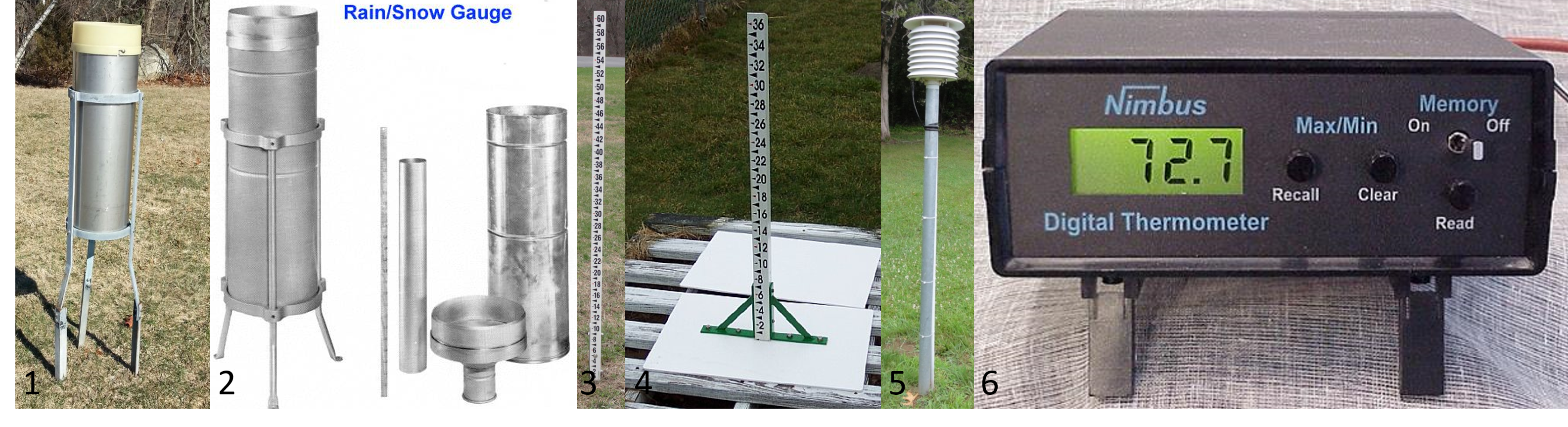
The instrument used for recording precipitation is the 8-inch Standard Rain Gauge (SRG); consisting of an outer/overflow can, inner tube, funnel, precipitation stick and tripod support.
The funnel guides rain into the inner tube. In order to provide rainfall measurements to the hundredths of an inch, the measuring tube has a cross sectional area that is one-tenth the cross-section of the funnel. Therefore, when 1 inch of rain falls into the funnel, it fills the measuring tube to a depth of 10 inches. Accordingly, the scale of the measuring stick used with the SRG is graduated to hundredths of an inch.
The SRG becomes a snow gauge in the winter. The measuring tube and funnel are removed, allowing wintry precipitation to fall directly into the overflow can. At the time of observation, if there is snow in the overflow can, the COOP site will bring the snow gauge indoors, melting the snow with a pre-measured amount of hot water from the inner-tube, then pour both the melted snow and hot water back into the inner-tube, subtracting the amount of hot water added to get the true amount of water for the melted snow. Using the precipitation stick, the COOP site can then get the liquid measure of the wintry precipitation that fell.
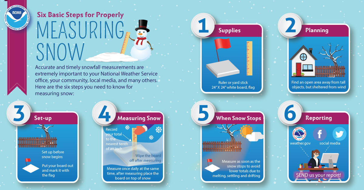
At the time of observation, COOP sites will also measure any snow that fell during the observation period. Using a snow stick they measure snowfall to the nearest tenth of an inch. They also will report any snow remaining on the ground (snow depth) to the nearest whole inch. Snow depth is the accumulated snow from previous snow storms.
Refresh yourself on measuring snowfall and depth here
Many observers record temperature readings: the 24-hour high and low temperatures and the temperature at observation. COOP sites report temperature to the nearest whole degree Fahrenheit. Most COOP sites are equipped with an electronic Maximum/Minimum Temperature System (MMTS) which electronically measures and memorizes the daily maximum and minimum temperatures.
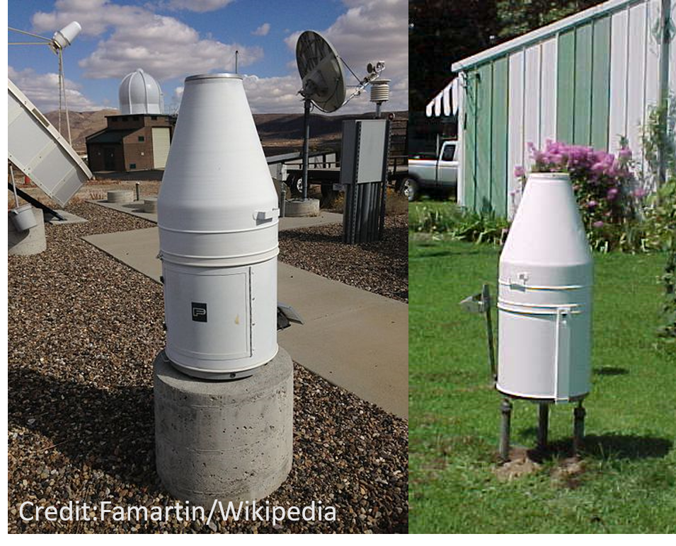
There are eleven Fischer Porter automated precipitation gauges across northern Arizona that are maintained by NWS Flagstaff. These sites measure precipitation at hourly increments. The data is manually downloaded every month with routine service being performed every six months. See the map on the Overview and Station Map tab to view where these sites are located!
|
Measure Light to Moderate Precipitation |
Measure Heavy Precipitation |
Understanding Rain Gauges |
Measuring Snow |
The collected data is invaluable in the NWS' ability to disseminate daily maximum and minimum temperatures, 24-hr precipitation, snowfall and snow depth to partners and customers of our Office. See below for COOP data at work across northern Arizona! Historical hourly precipitation data from COOP stations can be ordered here. Climate normals from COOP sites are available here.

