National Weather Service United States Department of Commerce
Click a location below for detailed forecast.

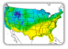
Last Map Update: Thu, Jul 4, 2024 at 4:55:00 am CDT

Significant heat stress conditions will continue today across much of the area, with peak heat index values of 110 to 120 degrees expected particularly along and northwest of the Natchez Trace. Elsewhere, peak heat index values will be closer to 105 to 110 degrees. Remember to stay hydrated and take frequent breaks when outdoors, including any Holiday festivities! Heat exhaustion and heat stroke will be likely with prolonged outdoor activity!
Dangerous heat and humidity will continue across the area into Friday before a front moving southward begins to offer a bit of relief. Remember to stay hydrated and avoid strenuous outdoor activities, and make sure neighbors, relatives and pets have a cool place to spend the day.
Isolated to scattered showers and storms are likely this afternoon with the better chances in the southeast. Dangerously hot and humid conditions are likely again today with highs in the mid and upper 90s.
Isolated showers will linger into early this evening before skies become partly cloudy overnight. Lows will remain warm, falling only into the mid to upper 70s.
A front will bring increased rain and storm chances on Friday, but not before temperatures rise into the lower to middle 90s for afternoon highs.


SAFE Page Briefing Probabilistic Graphics Past Weather Events Precip Maps Weather History
SAFE Page Briefing Probabilistic Graphics Past Events Recent Rainfall Weather History
Forecast Discussion
Gridded Forecast Hourly Forecast Forecast Discussion Local Climate Tornado Database Submit Storm Report
    Be Prepared Estar Preparado    
    Be Prepared Estar Preparado    


OSZAR »