National Weather Service United States Department of Commerce
Click a location below for detailed forecast.

Last Map Update: Thu, Jul 4, 2024 at 6:04:27 am EDT


Hot weather to continue. A low chance of showers and storms today, primarily across elevated portions of East Tennessee into southwest Virginia. Storm coverage should diminish after sunset. Friday into Saturday morning will have better chances for rainfall as a front moves toward the Tennessee Valley and the southern Appalachians.
Daily climate data (normals and records) for today for the sites plotted. The current normals period is 1991-2020.

 Current Weather Observations...
Location Time
(EDT)
Weather Vsby.
(SM)
Temp.
(ºF)
Dewpt.
(ºF)
Hum.
(%)
Wind
(mph)
Wind Chill / Heat Index
(ºF)
Pres.
(in)
Abingdon VA05:35Clear7696691CALM-30.12
Andrews-Murphy NC05:29Overcast10686695CALM-30.14
Chattanooga TN04:53Clear10787179CALM-30.04
Crossville TN04:53Clear10746984S 3-30.08
Dalton GA05:35Clear10777490SSE 5-30.04
Knoxville TN (McGhee-Tyson)04:53Partly Cloudy10767081CALM-30.03
Middlesboro KY05:35Clear10717096CALM-30.07
Monroe Cnty TN05:35Mostly Clear107171100CALM-30.04
Morristown TN05:35Mostly Cloudy107373100CALM-30.02
Oak Ridge TN04:53Clear10787179CALM-30.05
Tazewell Cnty VA05:35Partly Cloudy10SSE 5-30.14
Tri-Cities TN04:53Mostly Clear10706996CALM-30.09
Wise VA05:35Clear10696688SSW 6-30.14
Greeneville, TN05:35Mostly Cloudy10716888CALM-30.07


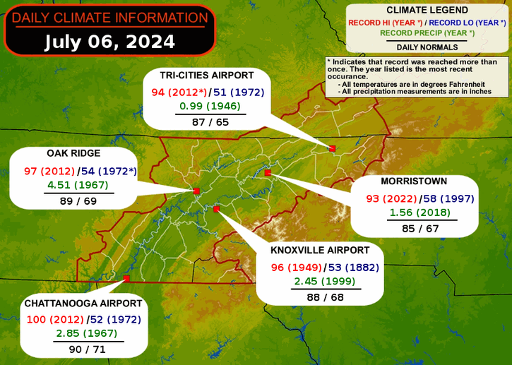
Local Weather History For July 4th...
Storms hit the area in 2006. $372,000 in wind damage. Flooding was reported in Rogersville.


Briefing Hydrology Past Weather Events Graphical Hazardous Weather Outlook for East Tennessee East Tennessee Observations
Decision Support Hydrology Past Weather Events GHWO Observations Gridded Forecast
Daily Climate for Middle Tennessee Local East Tennessee Climate Tornado Database Tropical Weather Information NOAA Weather Radio
IDSS Point Forecasts Daily Climate Local Climate Tornado Database Tropical Weather Radio
Daily Climate for Middle Tennessee Probabilistic Data for East Tennessee Virtual Tour of the NWS Morristown Office Skywarn Spotter Training for East Tennessee  
Being Prepared Estar Perparado Probabilistic Virtual Tour Spotter Training  
OSZAR »