Ohio RFC
River Forecast Center
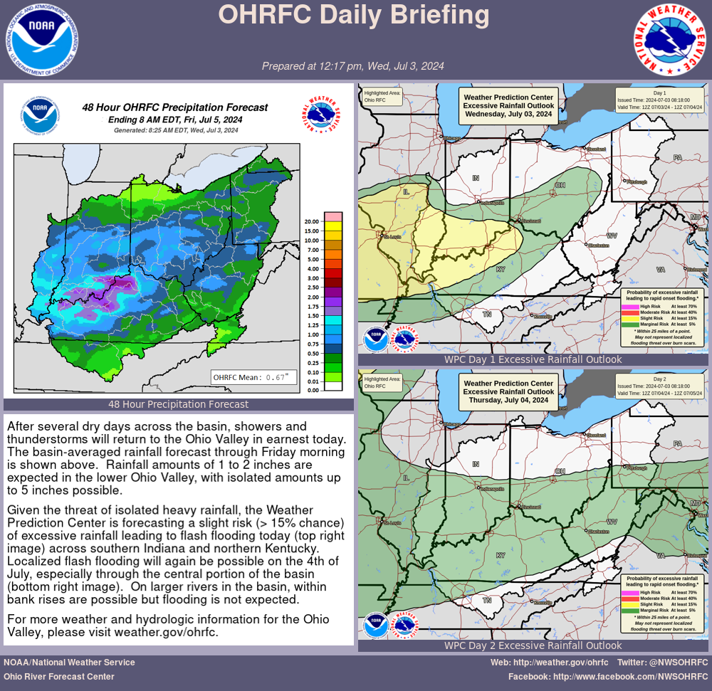
| WATER RESOURCES OUTLOOK NATIONAL WEATHER SERVICE OHIO RIVER FORECAST CENTER WILMINGTON OH 1223 PM EDT Friday June 28 2024 THE FOLLOWING IS THE 30-DAY WATER RESOURCES OUTLOOK FOR THE MONTH OF JULY .WATER RESOURCES STREAMFLOW OUTLOOK... The streamflow outlook for July calls for near to below normal streamflows for the Ohio River forecast basin. ..................................................................... .HYDROLOGIC FLOOD AND DROUGHT POTENTIAL... Flood potential is near normal as mesoscale convective systems could bring localized swaths of heavy rain at times. Pockets of drought have already developed across portions of the Ohio Valley given relatively dry June conditions, with some drought likely to persist or develop further in July. ..................................................................... .PAST 30 DAY HYDROLOGICAL AND METEOROLOGICAL REVIEW... RAINFALL DEPARTURES... Precipitation was below normal for most of the Ohio Valley and Lake Erie drainages over the past 30 days, with amounts generally ranging from 1 to 4 inches (25 to 75 percent of normal). Localized pockets of 4 to 6 inches were found east of Lake Erie in northern Pennsylvania, in northern Indiana, and also across western Kentucky (100 to 150 percent of normal). https://www.weather.gov/images/ohrfc/dynamic/latest30day.jpeg SOIL MOISTURE CONDITIONS... Near the end of June, soil moisture was below normal for much of the region (generally 10th to 30th percentile), with near normal soil moisture confined largely to northern portions of Indiana/Ohio/Pennsylvania, and portions of Middle Tennessee/adjacent western Kentucky. https://www.cpc.ncep.noaa.gov/soilmst/w.shtml STREAMFLOW CONDITIONS... Due to rainfall near the end of June, streamflows were generally above normal across portions of northern Indiana into northwest Ohio, northern Pennsylvania, and Middle Tennessee/adjacent portions of Kentucky. Elsewhere, streamflows were near to below normal. https://waterdata.usgs.gov/index.php?id=real ..................................................................... .ATMOSPHERIC TELECONNECTION AND OSCILLATION FORECASTS FOR THE NEXT MONTH... TELECONNECTION/OSCILLATION PATTERN ARCTIC OSCILLATION Positive trending Neutral = Below to near normal precipitation NORTH ATLANTIC OSCILLATION Positive trending Neutral = Below to near normal precipitation PACIFIC/NORTH AMERICAN TELECONNECTION Negative trending Neutral = No Correlation ENSO - EL NINO/LA NINA OSCILLATION El Nino = No Correlation https://www.cpc.ncep.noaa.gov ..................................................................... .TECHNICAL DISCUSSION... After a drier-than-normal June, a potentially more active pattern is setting up for the Ohio Valley in July. Medium range guidance suggests the region will be downstream of western US ridging for large portions of the month, which would tend to favor occasional mesoscale convective systems from the west impacting the region. This brings potential for localized stripes of heavy rain and flooding. Outside of these systems, which are difficult to predict ahead of time, the signal is for generally near to below normal rainfall to persist. Given dry antecedent conditions from June, this would favor some pockets of drought continuing and developing into July with near to below normal streamflows outside of where mesoscale convective systems end up tracking. ....................................................................... VISIT OUR WATER RESOURCES WEBSITE AT https://www.weather.gov/ohrfc/WRO IN ADDITION TO A 30-DAY STREAMFLOW OUTLOOK...YOU CAN ALSO OBTAIN A 60- AND 90-DAY OUTLOOK AT THE WEBSITE $$ |
US Dept of Commerce
National Oceanic and Atmospheric Administration
National Weather Service
Ohio RFC
1901 South State Route 134
Wilmington, OH 45177-9708
Comments? Questions? Please Contact Us.

