Ohio RFC
River Forecast Center
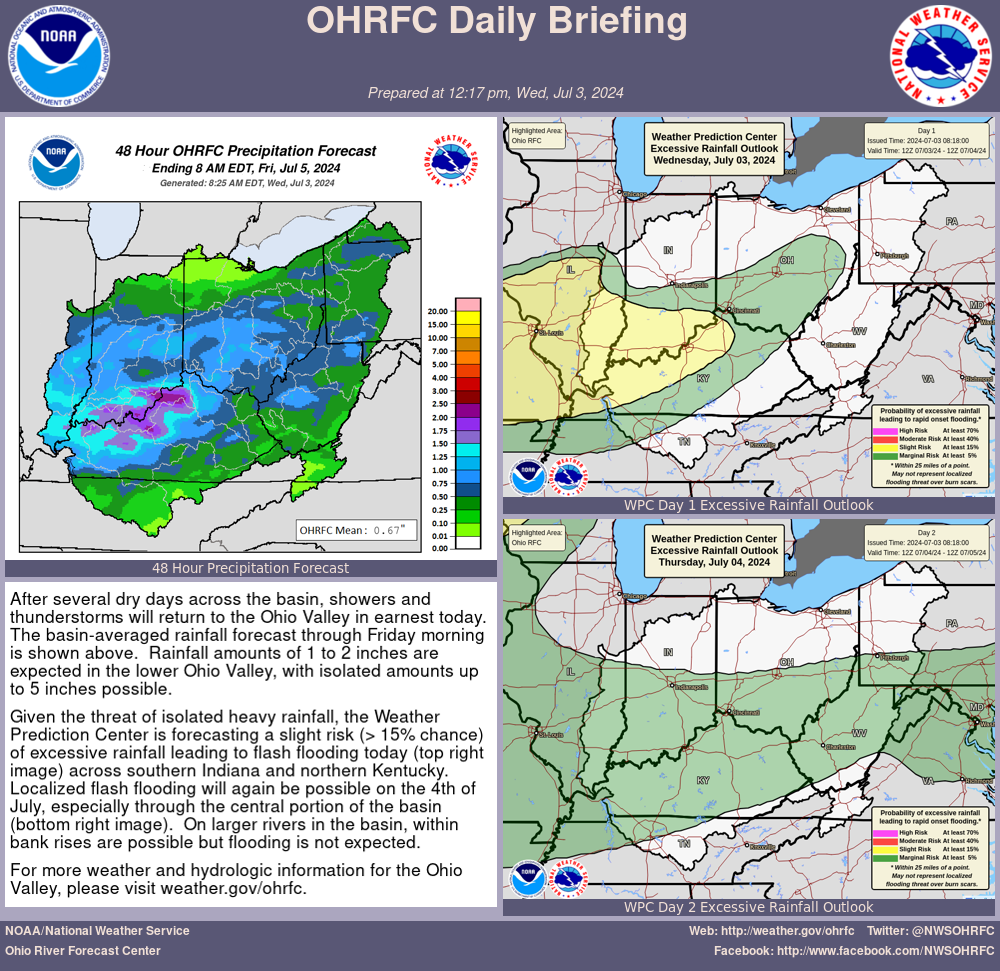
| WINTER/SPRING FLOOD POTENTIAL OUTLOOK NATIONAL WEATHER SERVICE OHIO RIVER FORECAST CENTER WILMINGTON OH 815 AM EDT Wednesday April 10 2024 ...Flood Potential for the next two weeks is above normal northern half to near normal southern half for the Ohio Valley... ...Flood Potential for the next 90-days is near normal for the Ohio Valley... PAST PRECIPITATION THE LAST 14 DAYS... Precipitation the last 14 days ranged significantly from just under an inch to over 5 inches (50 percent to 300 percent of normal). Heaviest amounts fell over the northern half of the basin with eastern Ohio and western Pennsylvania bearing the brunt of the 4 to 5+ inches. In general, anything north of the mainstem saw at least 150% of normal. The lower than normal precipitation was observed in western and southern Kentucky, middle Tennessee, and northern Virginia. For more information please visit: https://water.weather.gov/precip SOIL MOISTURE... Current soil moisture conditions across the region are roughly below normal south of the Ohio mainstem and normal to above normal north. State rankings: Southeast Illinois - Near normal Indiana - Near normal northern, below normal south Ohio - Near normal Western Pennsylvania - Above normal West Virginia - Near normal Kentucky - Below normal Tennessee - Below normal For more information please visit: https://www.cpc.ncep.noaa.gov/products/Drought/Monitoring/smp.shtml USGS STREAMFLOWS... The seven and 28-day streamflows are above to near normal northern basin, below southern. State rankings: Southeast Illinois - Near normal Indiana - Near normal Ohio - Near normal with areas of eastern Ohio above normal Western Pennsylvania - Near normal to above normal West Virginia - Near normal Kentucky - Below normal Tennessee - Below to near normal For more information please visit: https://waterdata.usgs.gov/nwis/rt RESERVOIR CONDITIONS... Reservoir storage will be in a transition period as projects begin to draw down to summer pools from their winter levels. The northern projects generally saw an increase in their pool levels in the past week with the bump in precipitation. OHIO RIVER FLOWS... Current flows along the Ohio River indicate above normal flows. Values are in percent of normal with above 100% are above normal and below 100% are below normal. Pittsburgh - 200% Huntington - 175% Cincinnati - 200% Louisville - 225% Evansville - 200% Smithland - 125% SNOW WATER CONTENT IN SNOWPACK... No current snowpack and snow water content across the Ohio Valley. For more information please visit: https://www.nohrsc.noaa.gov/nsa ICE COVER... Zero ice present in the Ohio Valley. 2-WEEK AND FLOOD OUTLOOK SUMMARY... The two-week outlook calls for above normal rainfall in the western half of the basin and continued normal to above normal flood potential in the northern half. The southern basin will see a likely increase in precipitation, but levels are starting generally below to normal so flood potential remains normal. In addition, the spring green-up is very well-along meaning more rain needed to runoff. OHIO RIVER AVERAGE FLOW FORECASTS THE NEXT 2 WEEKS... The Ohio River flow forecasts are expected to be above normal over the next 2 weeks, driven by last week's and this week's significant systems. Values are in percent of normal with greater than 100% being above normal and values below 100% being below normal. Pittsburgh - 200% Huntington - 225% Cincinnati - 200% Louisville - 200% Evansville - 200% Smithland - 175% For more information on the 10-day flood risk potential please visit: https://www.weather.gov/erh/mmefs Official forecasts can be found at: https://www.weather.gov/ohrfc The 90-day outlook in the Ohio Valley favors normal flood risk STATE BY STATE 90-DAY EXPECTED RIVER FLOOD RISK... Southeast Illinois - Minor to moderate flooding Indiana - Minor to isolated moderate flooding Ohio - Minor to isolated moderate flooding Western Pennsylvania - Minor to isolated moderate flooding Southwestern New York - Minor flooding West Virginia - Minor flooding Western Virginia - Minor flooding Kentucky - Isolated minor flooding Tennessee - Isolated minor flooding For more information on the 90-day flood risk please visit: https://water.weather.gov/ahps/long_range.php ADDITIONAL INFORMATION... Flood risk is defined as follows: Below normal - flooding will be limited Normal - minor flooding in the typical locations Above normal - widespread flooding with some moderate or major possible Winter/spring flood outlooks are issued weekly by the National Weather Service Ohio River Forecast Center during winter and early spring to summarize basin hydrological and meteorological conditions. It also assesses the potential for flood risk. The outlooks are based on current and forecast conditions. The Ohio River Forecast Center also issues a 30-90 day water resources outlook monthly throughout the year for a continuous water watch. This can be found at https://www.weather.gov/ohrfc/wro Factor considered in assessing flood potential include antecedent conditions, past precipitation, current streamflows and reservoir levels, soil moisture, water content in snow cover, ice conditions and future precipitation. $$ |
US Dept of Commerce
National Oceanic and Atmospheric Administration
National Weather Service
Ohio RFC
1901 South State Route 134
Wilmington, OH 45177-9708
Comments? Questions? Please Contact Us.

