When we obtain reports from across the region - whether from spotters, the general public, or solicited information from people like PennDOT or Emergency Personnel - we quality-check the data. We then try to issue Public Information Statements that summarize this information. Latest 24-hr Snowfall Report Map
Public Information Statement...Corrected
National Weather Service State College PA
952 PM EDT Mon Jul 1 2024
...NWS Damage Survey for 06/29/24 Downburst Event...
.Overview...
NWS State College meteorologists have confirmed that a downburst
occurred late Saturday afternoon, June 29th, 2024 in northern
Dauphin County. Maximum wind speeds were estimated to be between 75
and 95 mph.
...Millersburg Downburst...
Peak Wind /Estimated/: 75-95 mph
Path Length /statute/: 3 miles
Path Width /maximum/: 1.2 miles
Fatalities: 0
Injuries: 0
Start Date: June 29, 2024
Start Time: 5:38PM EDT
Start Location: Millersburg /Dauphin County/ PA
Start Lat/Lon: 40.54390 / -76.95261
End Date: June 29, 2024
End Time: 5:42PM EDT
End Location: Millersburg /Dauphin County/ PA
End Lat/Lon: 40.54562 / -76.90943
Survey Summary:
A line of severe thunderstorms began to produce wind damage in the
town of Millersburg at the Millersburg Area High School, located
just off North Street. A press box structure located above and just
behind a set of metal bleachers adjacent to the school`s athletic
field was blown off its supporting metal beams/foundation and
largely destroyed. A small ticket office on the other side of the
field was blown off its unsecured cement foundation pad and was
heavily damaged when it impacted a long length of bleachers next to
the field.
The line then continued eastward and produced sporadic wind
damage within several residential areas across Millersburg along
and East of Route 25. The damage consisted mostly of downed large
branches, as well as a few snapped and/or uprooted softwood and
hardwood trees.
The last observed area of storm damage in Millersburg was near
Landfill Road, where a few more more trees were snapped, or had
significant limb damage. The storm appeared to weaken farther to
the east, as no more damage points were observed.
We would like to thank the Dauphin County Emergency Management
Agency, Upper Paxton Township Fire/EOC officials, the local area
Skywarn Spotter and HAM Operator networks for their assistance.
We`d also like to thank members of the public who reported storm
related impacts.
&&
NOTE:
The information in this statement is preliminary and subject to
change pending final review of the event and publication in NWS
Storm Data.
$$
Evans/Jurewicz
Co-Operative (CoOp) Station Observations (Daily)
Once per day (usually around 7 am) more than 100 people across Central Pennsylvania send the NWS an observation covering the past 24 hours. Most report rain and snow totals. See the daily data from the CoOperative Observers
Daily Hydrometeorological Data Summary
National Weather Service State College PA
1202 PM EDT Wed Jul 3 2024
TEMPERATURE AND PRECIPITATION FOR THE PAST 24 HOURS.
TEMPERATURE SNOW
STATION OBSTIME PRECIP MAX MIN OBSN NEW TOTAL
Adams County
Biglerville 7am 0.00 85 60 66 M M
Cashtown 7am 0.00 82 57 62 0.0 0
Blair County
Altoona 7am M M M M M M
Altoona Airport 7am 0.00 81 60 71 M M
Tyrone 7am 0.00 M M M M M
Williamsburg 715am 0.00 84 60 69 M M
Cambria County
Ebensburg 8am 0.00 78 52 63 M M
Ebensburg 1SW 7am 0.00 M M 63 M M
Johnstown Airport 7am 0.00 76 60 67 M M
Prince Gallitzin 630am M M M M M M
Cameron County
Stevenson Dam 7am 0.00 81 49 58 0.0 0
Centre County
Philipsburg 2S 7am 0.00 76 53 66 M M
State College 8am M M M M M M
Clearfield County
Clearfield 7am 0.00 81 56 67 M M
Dubois 630am M M M M M M
Grampian 8am 0.00 81 47 74 M M
Clinton County
Lock Haven 7am 0.00 83 55 62 0.0 0
Renovo 7am 0.00 81 51 60 0.0 0
Cumberland County
Carlisle 7am 0.00 83 55 60 0.0 0
Shippensburg 12am M M M M M M
Dauphin County
Harrisburg 7am 0.00 85 60 72 M M
Harrisburg 1 NE 7am M M M M M M
Elk County
Ridgway 7am 0.00 80 44 68 0.0 0
Harford County MD
Conowingo Dam MD 7am 0.00 M M M M M
Huntingdon County
Raystown Lake 7am 0.00 84 59 72 M M
Lancaster County
Holtwood 7am 0.00 M M M M M
Lancaster 12am 0.00 86 56 65 M M
Lancaster Airport 7am 0.00 84 62 69 M M
Millersville 7am 0.00 84 65 71 M M
New Holland 12am 0.00 86 56 68 0.0 0
Safe Harbor 7am 0.00 83 63 69 M M
Lebanon County
Lebanon 2W 12am 0.00 81 56 67 0.0 0
Fort Indiantown Gap 7am 0.00 68 59 68 M M
Lycoming County
Williamsport 7am 0.00 82 53 70 M M
Mckean County
Bradford 8am 0.00 80 46 68 0.0 0
Bradford Airport 7am 0.00 80 57 69 M M
Kane 7am 0.00 78 40 58 0.0 0
Mifflin County
Lewistown 7am 0.00 84 53 63 0.0 0
Northumberland County
Sunbury 7am 0.00 82 54 66 M M
Potter County
Coudersport 1SW 7am M M M M M M
Galeton 8am 0.00 M M M M M
Schuylkill County
Mahanoy City 7am 0.00 80 58 64 M M
Pine Grove 7am 0.00 M M 58 0.0 0
Snyder County
Selinsgrove 7am M M M M M M
Selinsgrove Airport 7am 0.00 82 53 71 M M
Somerset County
Confluence 7am 0.00 82 48 55 M M
Glencoe 7am M M M M M M
Hidden Valley 8am 0.00 76 55 63 0.0 0
Laurel Summit 7am 0.00 74 51 61 M M
Somerset 7am 0.00 M M 68 0.0 0
Windber 7SE 7am 0.00 77 50 63 0.0 0
Sullivan County
Laporte 7am 0.00 75 49 61 0.0 0
Tioga County
Covington 7am M M M M M M
Cowanesque Dam 7am 0.00 79 50 65 M M
Tioga Hammond Dam 7am 0.00 79 48 65 M M
Wellsboro 7am 0.00 76 48 62 0.0 0
Union County
Lewisburg 7am 0.00 80 59 67 0.0 0
Warren County
Kinzua Dam 7am M M M M M M
Warren 7am 0.00 81 47 65 0.0 0
York County
New Cumberland 7am 0.00 85 58 73 M M
Thomasville 7am 0.00 83 64 71 M M
$$
Seasonal Totals
Select Season:
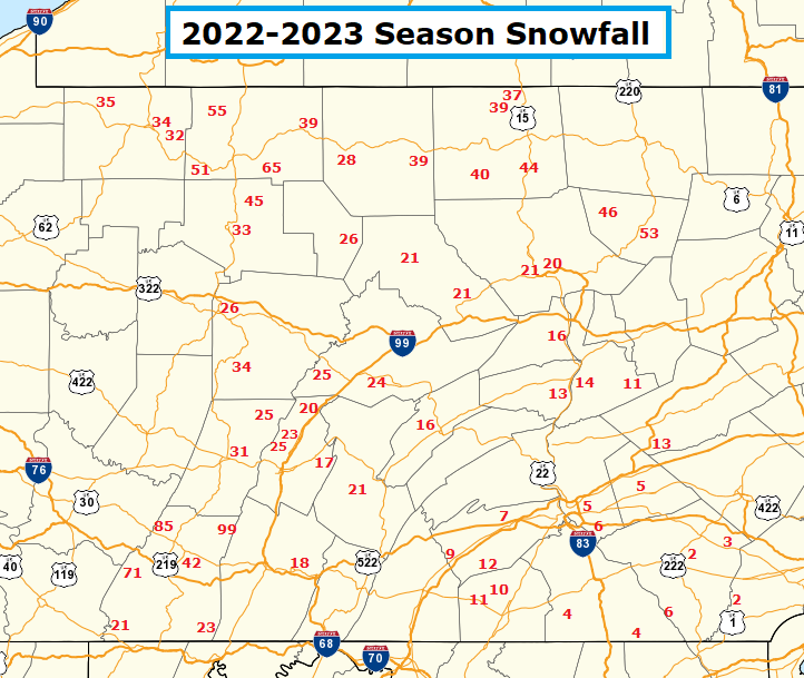
TIP: right-click on image and choose "View Image" to see the map at full size.
Seasonal Normals
What is normal (average) for my location?
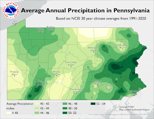
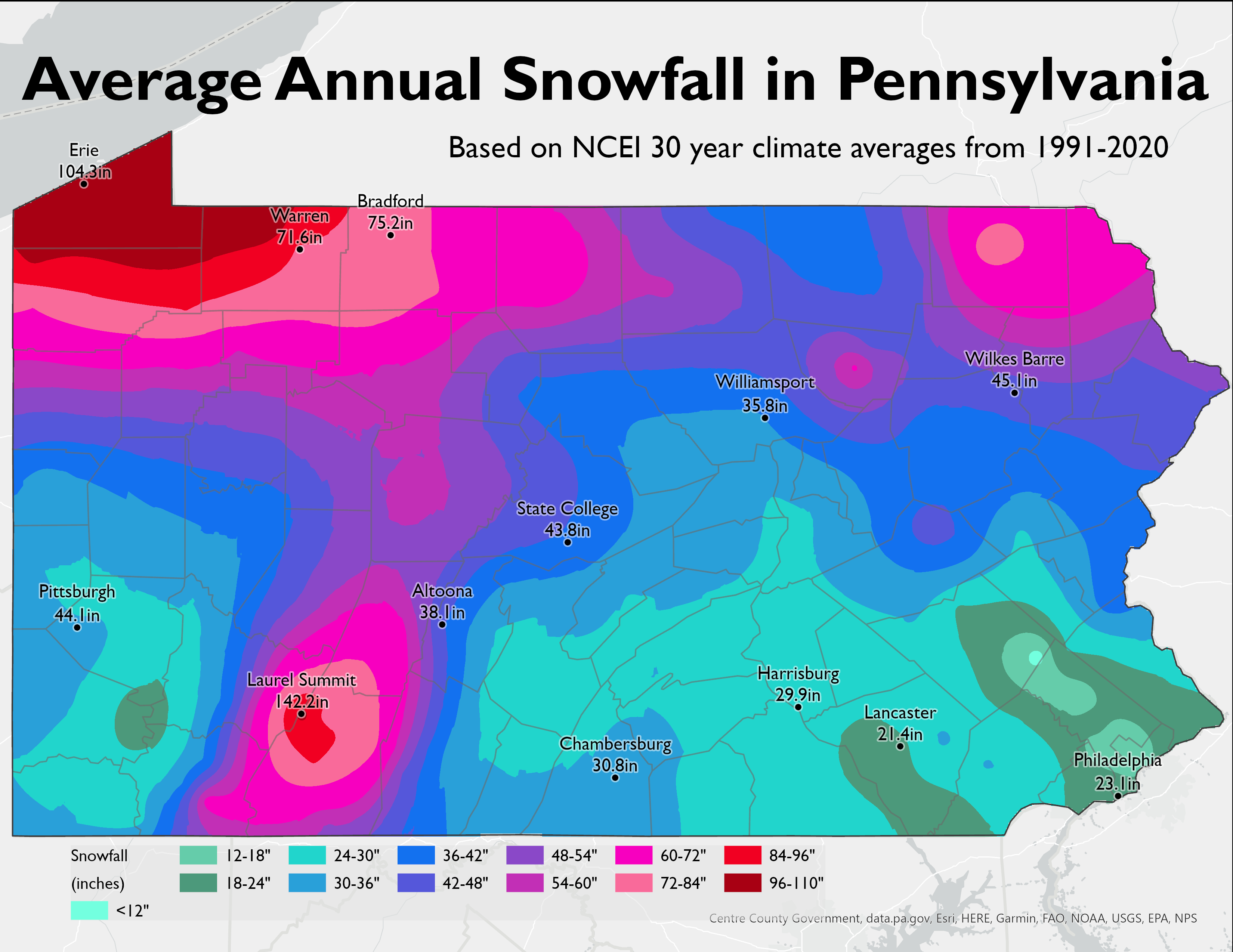
Check the map below, which lists the Average Annual Snowfall for Pennsylvania. Then, if you need further/more-detailed (monthly averages) information, check the Climate Database for a location near you.
Select:
"Monthly avgs/totals" from Col #1 (Product)
Choose a location near to you from Col #2 (Location)
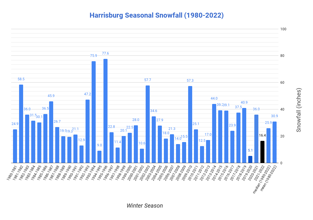
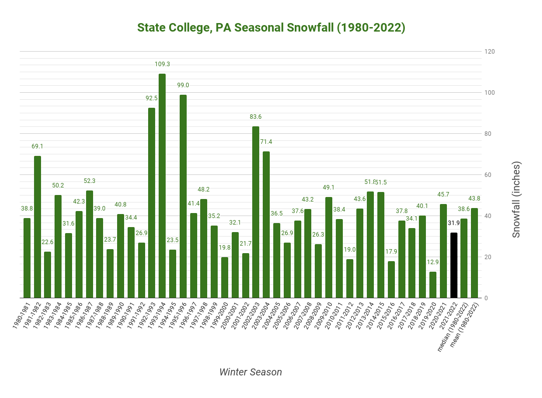
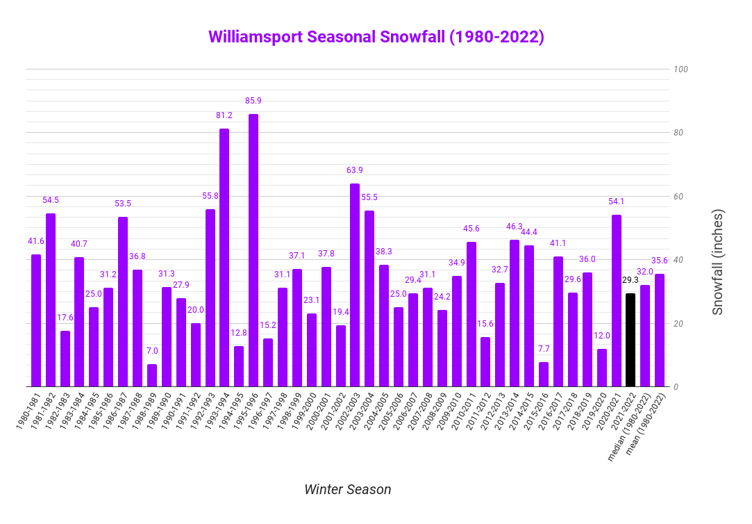
The following charts show the individual winter season snowfalls since 1980-1981. Continuous weather records have been kept since 1888 in Harrisburg, and since 1895 in both Williamsport and State College. Scroll down to see the larger images.
Harrisburg, PA Site Snowfall for recent winter seasons.
State College, PA Co-Operative Observation Site Snowfall for recent winter seasons.
Williamsport, PA Site Snowfall for recent winter seasons.
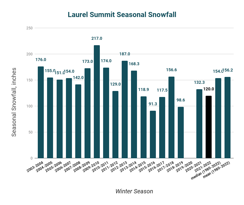
Laurel Summit, PA Co-Operative Observation Site Snowfall for recent winter seasons.
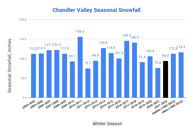
Chandler Valley (NW Warren County) Co-Operative Observation Site Snowfall for recent winter seasons.


 Send Us a Report