
Severe thunderstorms will be possible on Independence Day, mainly across parts of the Upper Mississippi Valley, Ozarks, and southern/central Plains. Excessive heat with possible record highs and warm overnight lows will continue to impact much of the West into next week. Dangerous heat is expected across the Southern U.S. and Mid-Atlantic into the weekend. Read More >
Wakefield, VA
Weather Forecast Office
Full Domain Shown Below:
|
|
|
|
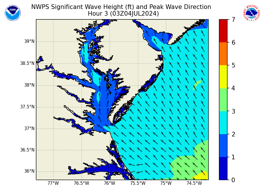
These models forecasts are produced by WFO Wakefield, VA using the NWPS wave models and the Real Time Ocean Forecast System
NWPS accounts for the following physics:
In here you will see 3-hourly forecast outputs for significant wave height, peak wave direction, peak wave period, and significant swell height (heights in feet and periods in seconds). Additionally, individual wave system heights, periods, and directions contributing to the significant wave heights are provided further below. In addition you will see the wind speed and direction used as input for the models. Our local version of NWPS also uses input from WAVEWATCH III for boundary conditions. NOTE: Significant Swell Height output from NWPS is the average height of the highest 1/3 of the group of waves with periods of 10 secs or longer. |
CURRENT CONDITIONS
MARINE OBSERVATIONS
EARTHQUAKE MONITOR
TIDES NEXT FEW DAYS
LAND OBSERVATIONS HOURLY
RIVER LEVEL SUMMARY
GIS MARINE REPORTS
FORECASTS
Zone Forecast
Marine Forecast
Fire Weather Forecast
Air Quality Forecast
River Level Forecast
Summer Rip Current Forecast
Graphical Rain Totals
Core TEXT Products
RSS/XML
MODEL-DATA
Statistical Models
NCEP Models
ENSO
Nearshore Wave Prediction System (NWPS)
Meso Analysis
Local WRF Model
SAFETY/EDUCATION
Awareness Weeks Messages
CoCoRAHS
SkyWarn
Storm Ready
Weather Ready Nation
Brochures
Safety
WindChill Chart
Heat Index
US Dept of Commerce
National Oceanic and Atmospheric Administration
National Weather Service
Wakefield, VA
10009 General Mahone Highway
Wakefield, VA 23888
757-899-4200
Comments? Questions? Please Contact Us.


 Coastal Flood
 Heat
Heat